ALGERIA
Geography: Nearly four times the size of Texas and the largest country on the continent, Algeria is bordered on the west by Morocco and Western Sahara and on the east by Tunisia and Libya. The Mediterranean Sea is to the north, and to the south are Mauritania, Mali, and Niger. The Saharan region, which is 85% of the country, is almost completely uninhabited. The highest point is Mount Tahat in the Sahara, which rises 9,850 ft (3,000 m).
Government: Parliamentary republic.
History: Excavations in Algeria have indicated that Homo erectus resided there between 500,000 and 700,000 years ago. Phoenician traders settled on the Mediterranean coast in the 1st millennium B.C. As ancient Numidia, Algeria became a Roman colony, part of what was called Mauretania Caesariensis, at the close of the Punic Wars (145 B.C. ). Conquered by the Vandals about A.D. 440, it fell from a high state of civilization to virtual barbarism, from which it partly recovered after an invasion by Arabs about 650. Christian during its Roman period, the indigenous Berbers were then converted to Islam. Falling under the control of the Ottoman Empire by 1536, Algiers served for three centuries as the headquarters of the Barbary pirates. Ostensibly to rid the region of the pirates, the French occupied Algeria in 1830 and made it a part of France in 1848.
Algerian independence movements led to the uprisings of 1954–1955, which developed into full-scale war. In 1962, French president Charles de Gaulle began the peace negotiations, and on July 5, 1962, Algeria was proclaimed independent. In Oct. 1963, Ahmed Ben Bella was elected president, and the country became Socialist. He began to nationalize foreign holdings and aroused opposition. He was overthrown in a military coup on June 19, 1965, by Col. Houari Boumédienne, who suspended the constitution and sought to restore economic stability. After his death, Boumédienne was succeeded by Col. Chadli Bendjedid in 1978. Berbers rioted in 1980 when Arabic was made the country's only official language. Algeria entered a major recession after world oil prices plummeted in the 1980s.
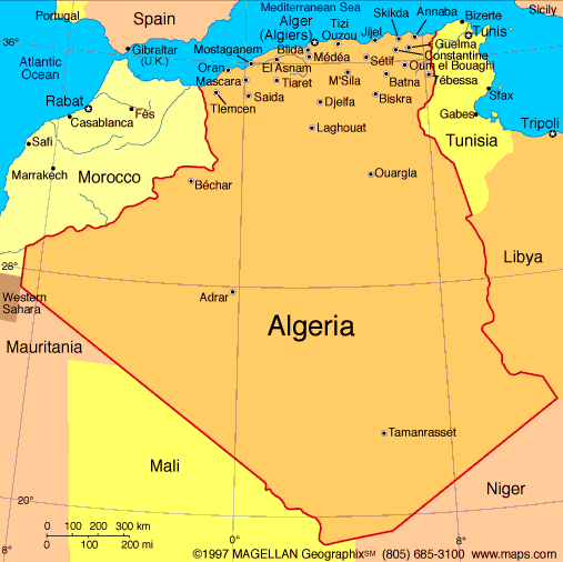
Map of Algeria
President: Abdel-Aziz Bouteflika (1999)
Prime Minister: Abdelmalek Sellal
(2012)
Total area: 919,590 sq mi (2,381,741
sq km)
Population (2014 est.):
38,813,722 (growth rate: 1.88%); birth rate: 23.99/1000; infant
mortality rate: 21.76/1000; life expectancy: 76.39; density per sq mi:
42.2
Capital and largest city (2011 est.):
Algiers, 2,916,000
Other large cities:
Oran, 783,000; Constantine, 530,100; Batna, 278,100; Annaba,
246,700
Monetary unit: Dinar
National name: Al Jumhuriyah al
Jaza'iriyah ad Dimuqratiyah ash Sha'biyah
Ethnicity/race:
Arab-Berber 99%, European less than 1%
Religion:
Muslim (official; predominantly Sunni) 99%, other (includes Christian and Jewish)
National Holiday:
Revolution Day, November 1
Literacy rate: 79%
Economic summary:
GDP/PPP (2013 est.):
$284.7 billion; per capita $7,500. Real growth rate: 3.1%.
Inflation: 3.9%. Unemployment: 10.3%. Arable
land: 3.15%. Agriculture: wheat, barley, oats, grapes,
olives, citrus, fruits; sheep, cattle. Labor force: 11.15
million; agriculture 14%, industry 13.4%, construction and public
works 10%, trade 14.6%, government 32%, other 16% (2003 est.).
Industries: petroleum, natural gas, light industries, mining,
electrical, petrochemical, food processing. Natural resources:
petroleum, natural gas, iron ore, phosphates, uranium, lead, zinc.
Exports: $68.2 billion f.o.b. (2013 est.): petroleum, natural
gas, and petroleum products 97%. Imports: $55.02 billion f.o.b.
(2013 est.): capital goods, foodstuffs, consumer goods. Major
trading partners: France, Italy, China, Germany, Spain, U.S.,
Netherlands, Canada, UK, Brazil (2012)
Communications: Telephones:
main lines in use: 3.2 million (2012); mobile cellular: 37.692
million (2012). Internet hosts: 676 (2012). Internet
users: 4.7 million (2012).
Transportation: Railways: total: 3,973 km
(2011). Highways: total: 113,655 km;
(2011). Ports and harbors: Algiers, Annaba,
Arzew, Bejaia, Djendjene, Jijel, Mostaganem, Oran, Skikda.
Airports: 157 (2013).
International
disputes: Algeria and many other states reject Moroccan
administration of Western Sahara; the Polisario Front, exiled in
Algeria, represents the Sahrawi Arab Democratic Republic; Algeria's
border with Morocco remains an irritant to bilateral relations, each
nation accusing the other of harboring militants and arms smuggling;
dormant disputes include Libyan claims of about 32,000 sq km still
reflected on its maps of southeastern Algeria and the National
Liberation Front's (FLN) assertions of a claim to Chirac Pastures in
southeastern Morocco.
-------------------- o --------------------
No comments:
Post a Comment