ANGOLA
Geography: Angola, more than three times the size of California, extends for more than 1,000 mi (1,609 km) along the South Atlantic in southwest Africa. The Democratic Republic of the Congo and the Republic of Congo are to the north and east, Zambia is to the east, and Namibia is to the south. A plateau averaging 6,000 ft (1,829 m) above sea level rises abruptly from the coastal lowlands. Nearly all the land is desert or savanna, with hardwood forests in the northeast.
Government: Angola underwent a transition from a one-party socialist state to a nominally multiparty democracy in 1992.
History: The original inhabitants of Angola are thought to have been Khoisan speakers. After 1000, large numbers of Bantu speakers migrated to the region and became the dominant group. Angola derives its name from the Bantu kingdom of Ndongo, whose name for its king is ngola.
Explored by the Portuguese navigator Diego Cão in 1482, Angola became a link in trade with India and Southeast Asia. Later it was a major source of slaves for Portugal's New World colony of Brazil. Development of the interior began after the Berlin Conference in 1885 fixed the colony's borders, and British and Portuguese investment fostered mining, railways, and agriculture.
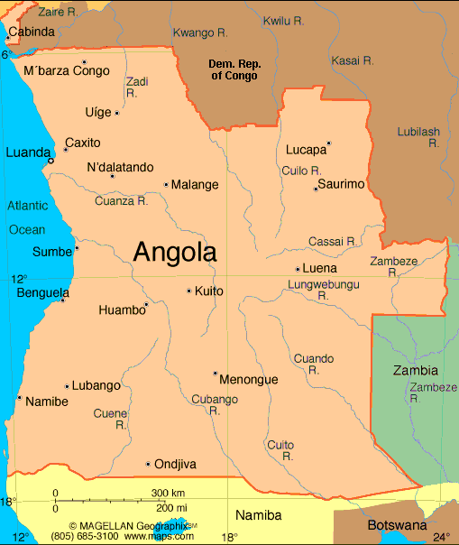
Map of Angola
President:
José Eduardo dos Santos (1979)
Prime
Minister: position abolished (2012)
Total area: 481,350 sq mi (1,246,699 sq km)
Population (2014 est.): 19,088,106 (growth
rate: 2.78%); birth rate: 38.97/1000; infant mortality rate: 79.99/1000;
life expectancy: 55.29
Capital and largest city (2011 est.):
Luanda, 5.068 million
Other large cities: Huambo, 1.098 million
Monetary unit: New
Kwanza
National name: Republica de
Angola
Languages:
Portuguese (official), Bantu and other African
languages
Ethnicity/race:
Ovimbundu 37%, Kimbundu 25%, Bakongo 13%,
mestico (mixed European and Native African) 2%, European 1%, other
22%
Religions:
Indigenous 47%, Roman Catholic 38%, Protestant
15% (1998 est.)
Literacy rate:
70.4% (2011 est.)
Economic summary:
GDP/PPP (2013 est.): $131.8 billion; per capita $6,300. Real
growth rate: 5.6%. Inflation: 8.9%. Unemployment:
n.a. Arable land: 3.29%.
Agriculture: bananas, sugarcane, coffee, sisal, corn, cotton,
manioc (tapioca), tobacco, vegetables, plantains; livestock; forest
products; fish. Labor force: 9.018 million; agriculture 85%,
industry and services 15% (2003 est.). Industries: petroleum;
diamonds, iron ore, phosphates, feldspar, bauxite, uranium, and gold;
cement; basic metal products; fish processing; food processing,
brewing, tobacco products, sugar; textiles; ship repair. Natural
resources: petroleum, diamonds, iron ore, phosphates, copper,
feldspar, gold, bauxite, uranium. Exports: $70.84 billion
(2013 est.): crude oil, diamonds, refined petroleum products,
gas, coffee, sisal, fish and fish products, timber, cotton.
Imports: $26.09 billion (2013 est.): machinery and
electrical equipment, vehicles and spare parts; medicines, food,
textiles, military goods. Major trading partners: U.S., China,
India, South Africa, Portugal, Brazil (2012)
Communications: Telephones: main lines in
use: 303,000 (2012); mobile cellular: 9.8 million (2012). Broadcast media:
state controls all broadcast media with nationwide reach; state-owned
Televisao Popular de Angola (TPA) provides terrestrial TV service on 2
channels; a third TPA channel is available via cable and satellite; TV
subscription services are available; state-owned Radio Nacional de
Angola (RNA) broadcasts on 5 stations; about a half dozen private radio
stations broadcast locally (2008). Internet hosts:
20,703 (2012). Internet users: 606,700 (2009).
Transportation: Railways: total: 2,764 km
(2008). Highways: total: 51,429 km; paved: 5,349 km; unpaved:
46,080 km (2001). Waterways: 1,300 km (2011). Ports and
harbors: Cabinda, Luanda, Lobito, Namibe. Airports: 176 (2013).
International disputes: Democratic Republic of Congo accuses Angola of shifting monuments.
-------------------- o --------------------
No comments:
Post a Comment