BANGLADESH
Geography: Bangladesh, on the northern coast of the Bay of Bengal, is surrounded by India, with a small common border with Myanmar in the southeast. The country is low-lying riverine land traversed by the many branches and tributaries of the Ganges and Brahmaputra rivers. Tropical monsoons and frequent floods and cyclones inflict heavy damage in the delta region.
Government: Parliamentary democracy.
History: What is now called Bangladesh is part of the historic region of Bengal, the northeast portion of the Indian subcontinent. Bangladesh consists primarily of East Bengal (West Bengal is part of India and its people are primarily Hindu) plus the Sylhet district of the Indian state of Assam.
The earliest reference to the region was to a kingdom called Vanga, or Banga (c. 1000 B.C. ). Buddhists ruled for centuries, but by the 10th century Bengal was primarily Hindu. In 1576, Bengal became part of the Mogul Empire, and the majority of East Bengalis converted to Islam. Bengal was ruled by British India from 1757 until Britain withdrew in 1947, and Pakistan was founded out of the two predominantly Muslim regions of the Indian subcontinent. For almost 25 years after independence from Britain, its history was part of Pakistan's ( see Pakistan ).
West Pakistan and East Pakistan were united by religion (Islam), but their peoples were separated by culture, physical features, and 1,000 miles of Indian territory.
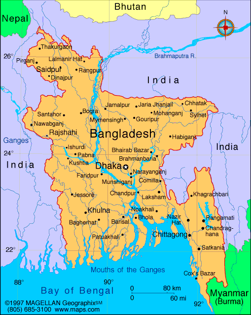
Map of Bangladesh
President: Abdul Hamid (2013)
Prime Minister: Sheikh Hasina
(2009)
Land area: 51,703 sq mi (133,911 sq km);
total area: 55,598 sq mi (144,000 sq km)
Population (2014 est.): 166,280,712 (growth
rate: 1.6%); birth rate: 21.61/1000; infant mortality rate: 45.67/1000;
life expectancy: 70.65
Capital and largest city (2011 est.):
Dhaka, 15.391 million
Other large cities:
Chittagong, 5.239 million; Khulna, 1.781 million; Rajshahi 932,000
Monetary unit: Taka
Principal languages:
Bangla (official), English
Ethnicity/race:
Bengali 98%, tribal groups, non-Bengali Muslims
(1998)
Religions:
Muslim 89.5%, Hindu 9.6%, other 0.9% (2004)
National Holiday:
Independence Day, March 26
Literacy rate: 57.7% (2011 est.)
Economic summary: GDP/PPP (2013 est.):
$324.6 billion; per capita $2,100. Real growth rate: 5.8%.
Inflation: 7.6%. Unemployment: 5% (includes
underemployment). Arable land: 52.97%. Agriculture:
rice, jute, tea, wheat, sugarcane, potatoes, tobacco, pulses,
oilseeds, spices, fruit; beef, milk, poultry. Labor force: 78.62
million; note: extensive export of labor to Saudi Arabia, Kuwait, UAE,
Oman, Qatar, and Malaysia; agriculture 47%, industry 13%, services 40%
(2013). Industries: cotton textiles, jute, garments, tea
processing, paper newsprint, cement, chemical fertilizer, light
engineering, sugar. Natural resources: natural gas, arable
land, timber, coal. Exports: $26.91 billion (2013 est.):
garments, jute and jute goods, leather, frozen fish and seafood. Imports: $32.94 billion (2013 est.): machinery and
equipment, chemicals, iron and steel, textiles, foodstuffs, petroleum
products, cement. Major trading partners: U.S., Germany,
UK, France, Italy, India, China, Kuwait, Japan, Spain, Canada, Malaysia, Republic of Korea
(2013).
Member of Commonwealth of Nations
Communications: Telephones: main
lines in use: 962,000 (2012); mobile cellular: 97.18 million (2011).
Broadcast media: state-owned Bangladesh
Television (BTV) operates 1 terrestrial TV station, 3 radio networks,
and about 10 local stations; 8 private satellite TV stations and 3
private radio stations also broadcasting; foreign satellite TV stations
are gaining audience share in the large cities; several international
radio broadcasters are available (2007). Internet
hosts: 71,164 (2012). Internet users: 617,300 (2009).
Transportation: Railways: total: 2,622 km. Highways: total: 21, 269 km; paved: 1,063 km;
unpaved: 20,206 km (2010). Waterways: 8,370 km; note: includes
3,060 km main cargo routes (2005). Ports and harbors:
Chittagong, Mongla Port. Airports: 18 (2013).
International disputes:
Bangladesh referred its maritime boundary claims with Burma and India
to the International Tribunal on the Law of the Sea; Indian Prime
Minister Singh's September 2011 visit to Bangladesh resulted in the
signing of a Protocol to the 1974 Land Boundary Agreement between India
and Bangladesh, which had called for the settlement of longstanding
boundary disputes over undemarcated areas and the exchange of
territorial enclaves, but which had never been implemented; Bangladesh
struggles to accommodate 29,000 Rohingya, Burmese Muslim minority from
Arakan State, living as refugees in Cox's Bazar; Burmese border
authorities are constructing a 200 km (124 mi) wire fence designed to
deter illegal cross-border transit and tensions from the military
build-up along border.
-------------------- o --------------------
No comments:
Post a Comment