BARBADOS
Geography: An island in the Atlantic about 300 mi (483 km) north of Venezuela, Barbados is only 21 mi long (34 km) and 14 mi across (23 km) at its widest point. It is circled by fine beaches and narrow coastal plains. The highest point is Mount Hillaby (1,105 ft; 337 m) in the north-central area.
Government: Parliamentary democracy.
History: Barbados is thought to have been originally inhabited by Arawak Indians. By the time Europeans explored the island, however, it was uninhabited. The Portuguese were the first Europeans to set foot on the island, but it was the British who first established a colony there in 1627. Colonists first cultivated tobacco and cotton, but by the 1640s they had switched to sugar, which was enormously profitable. Slaves were brought in from Africa to work sugar plantations, and eventually the population was about 90% black. A slave revolt took place in 1816; slavery was abolished in the British Empire in 1834.
Barbados was the administrative headquarters of the Windward Islands until it became a separate colony in 1885. Barbados was a member of the Federation of the West Indies from 1958 to 1962. Britain granted the colony independence on Nov. 30, 1966, and it became a parliamentary democracy within the Commonwealth.
Since independence, Barbados has been politically stable. In May 2003, Prime Minister Arthur won a third term. In parliamentary elections in January 2008, the Democratic Labour Party won 20 out of 30 seats. Former junior finance minister David Thompson took over as prime minister.
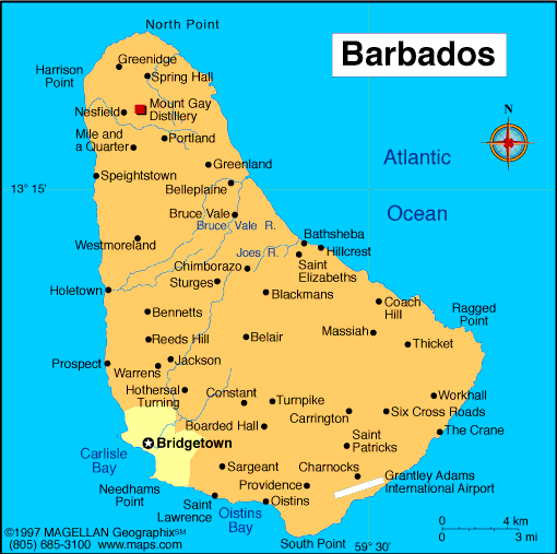
Map of Barbados
Sovereign: Queen Elizabeth II
(1952)
Governor-General: Sir Elliot Belgrave (2012)
Prime Minister: Freundel Stuart
(2010)
Land area: 166 sq mi (430 sq km); total
area 166 sq mi (431 sq km)
Population (2014 est.): 289,680 (growth
rate: 0.33%); birth rate: 11.97/1000; infant mortality rate:
10.93/1000; life expectancy: 74.99
Capital and largest city (2011 est.):
Bridgetown, 122,000
Monetary unit: Barbados dollar
Language:
English (official), Bajan (English-based creole language, widely spoken in informal settings)
Ethnicity/race:
black 92.4%, white 2.7%, mixed 3.1%, East Indian 1.3%, other 0.2%, unspecified 0.2% (2010 est.
Religions:
Protestant 66.3% (includes Anglican 23.9%, other Pentecostal
19.5%, Adventist 5.9%, Methodist 4.2%, Wesleyan 3.4%, Nazarene 3.2%,
Church of God 2.4%, Baptist 1.8%, Moravian 1.2%, other Protestant .8%),
Roman Catholic 3.8%, other Christian 5.4% (includes Jehovah's Witness
2.0%, other 3.4%), Rastafarian 1%, other 1.5%, none 20.6%, unspecified
1.2% (2010 est.)
National Holiday:
Independence Day, November 30
Literacy rate: 99.7% (2012 est.)
Economic summary: GDP/PPP (2013
est.): $7.004 billion; per capita: $25,100. Real growth rate:
–0.8%. Inflation: 2.1% (2011 est.). Unemployment:
11.4% (2011 est.). Arable land: 27.91%.
Agriculture: sugarcane, vegetables, cotton. Labor force:
141,800 (2013 est.); services 75%, industry 15%, agriculture 10%
(1996 est.). Industries: tourism, sugar, light manufacturing,
component assembly for export. Natural resources: petroleum,
fish, natural gas. Exports: $1.051 billion (2013 est): sugar
and molasses, rum, other foods and beverages, chemicals, electrical
components. Imports: $1.674 billion (2013 est.): consumer
goods, machinery, foodstuffs, construction materials, chemicals,
fuel, electrical components. Major trading partners: U.S.,
UK, Trindad and Tobago, St. Lucia, Jamaica, St. Vincent and the
Grenadines, Antigua and Barbuda, St. Kitts and Nevis, China (2012).
Member of Commonwealth of Nations
Communications: Telephones: main lines
in use: 144,000 (2012); mobile cellular: 347,000 (2012). Broadcast media: government-owned
Caribbean Broadcasting Corporation (CBC) operates the lone terrestrial
TV station; CBC also operates a multi-channel cable TV subscription
service; roughly a dozen radio stations, consisting of a CBC-operated
network operating alongside privately owned radio stations (2007). Internet hosts: 1,524 (2012). Internet users:
188,000 (2008).
Transportation: Railways: 0 km.
Highways: total: 1,600 km; paved: 1,600 km (2012). Ports
and harbors: Bridgetown. Airports: 1 (2013).
International disputes:
Barbados and Trinidad and Tobago abide by the April 2006 Permanent
Court of Arbitration decision delimiting a maritime boundary and
limiting catches of flying fish in Trinidad and Tobago's exclusive
economic zone; joins other Caribbean states to counter Venezuela's claim
that Aves Island sustains human habitation, a criterion under the UN
Convention on the Law of the Sea, which permits Venezuela to extend its
Economic Exclusion Zone/continental shelf over a large portion of the
eastern Caribbean Sea.
-------------------- o --------------------
No comments:
Post a Comment