BENIN
Geography: This West African nation on the Gulf of Guinea, between Togo on the west and Nigeria on the east, is about the size of Tennessee. It is bounded by Burkina Faso and Niger on the north. The land consists of a narrow coastal strip that rises to a swampy, forested plateau and then to highlands in the north. A hot and humid climate blankets the entire country.
Government: Republic under a multiparty democratic rule.
History: The Abomey kingdom of the Dahomey, or Fon, peoples was established in 1625. A rich cultural life flourished, and Dahomey's wooden masks, bronze statues, tapestries, and pottery are world renowned. One of the smallest and most densely populated regions in Africa, Dahomey was annexed by the French in 1893 and incorporated into French West Africa in 1904. It became an autonomous republic within the French Community in 1958, and on Aug. 1, 1960, Dahomey was granted its independence within the Community.
Gen. Christophe Soglo deposed the first president, Hubert Maga, in an army coup in 1963. He dismissed the civilian government in 1965, proclaiming himself chief of state. A group of young army officers seized power in Dec. 1967, deposing Soglo. In Dec. 1969, Benin had its fifth coup of the decade, with the army again taking power. In May 1970, a three-man presidential commission with a six-year term was created to take over the government. In May 1972, yet another army coup ousted the triumvirate and installed Lt. Col. Mathieu Kérékou as president. Between 1974 and 1989 Dahomey embraced socialism, and changed its name to the People's Republic of Benin. The name Benin commemorates an African kingdom that flourished from the 15th to the 17th century in what is now southwest Nigeria. In 1990, Benin abandoned Marxist ideology, began moving toward multiparty democracy, and changed its name again, to the Republic of Benin.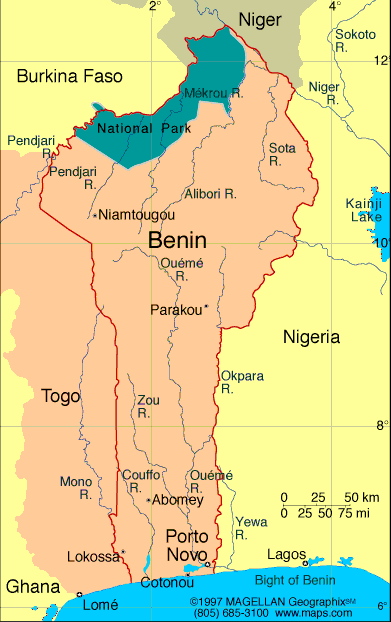
Map of Benin
Republic of Benin
President: Yayi Boni (2006)
Prime Minister: Lionel Zinsou (2015)
Land area: 42,710 sq mi (110,619 sq km);
total area: 43,483 sq mi (112,620 sq km)
Population (2014 est.): 10,160,556
(growth rate: 2.81%); birth rate: 36.51/1000; infant mortality rate:
57.09/1000; life expectancy: 61.07
Capital (2011 est.):
Porto-Novo (official), 314,000;
Largest
city and seat of government: Cotonou 924,000
Monetary unit: CFA Franc
National name: Republique du
Benin
Languages:
French (official), Fon and Yoruba (most common vernaculars
in south), tribal languages (at least six major ones in north)
Ethnicity/race:
Fon and related 39.2%, Adja and related 15.2%, Yoruba and
related 12.3%, Bariba and related 9.2%, Peulh and related 7%, Ottamari
and related 6.1%, Yoa-Lokpa and related 4%, Dendi and related 2.5%,
other 1.6% (includes Europeans), unspecified 2.9% (2002 census)
Religions:
Catholic 27.1%, Muslim 24.4%, Vodoun 17.3%, Protestant
10.4% (Celestial 5%, Methodist 3.2%, other Protestant 2.2%), other
Christian 5.3%, other 15.5% (2002 census)
National Holiday:
National Day, August 1
Literacy rate: 42.4% (2010)
Economic summary: GDP/PPP (2013
est.): $16.65 billion; per capita $1,600. Real growth rate:
5%. Inflation: 2.4%. Unemployment: n.a. Arable
land: 22.48%. Agriculture: cotton, corn, cassava
(tapioca), yams, beans, palm oil, peanuts;livestock. Labor
force: 3.662 million; Industries: textiles, food processing,
construction materials, cement. Natural resources: small
offshore oil deposits, limestone, marble, timber. Exports:
$1.108 billion (2013 est.): cotton, cashews, shea butter, textiles, palm
products, seafood. Imports: $1.835 billion (2013 est.):
foodstuffs, capital goods, petroleum products. Major trading
partners: India, China, U.S., France, Niger, Nigeria, Malaysia, Lebanon (2012).
Communications: Telephones: main lines
in use: 156,700 (2012); mobile cellular: 8.408 million (2012). Broadcast media;
state-run Office de Radiodiffusion et de Television du Benin (ORTB)
operates a TV station with multiple channels giving it a wide broadcast
reach; several privately-owned TV stations broadcast from Cotonou;
satellite TV subscription service is available; state-owned radio,
under ORTB control, includes a national station supplemented by a
number of regional stations; substantial number of privately-owned
radio broadcast stations; transmissions of a few international
broadcasters are available on FM in Cotonou (2007). Internet hosts: 491 (2012). Internet users: 200,100 (2009).
Transportation: Railways: total: 438 km
(2008). Highways: total: 16,000 km; paved: 1,400 km; unpaved: 14,600 km (2006.).
Waterways: 150 km (on River Niger along northern border)
(2011). Ports and harbors: Cotonou. Airports: 6 (2013
est.).
International disputes:
Talks continue between Benin and Togo on funding the Adjrala
hydroelectric dam on the Mona River; Benin retains a border dispute
with Burkina Faso around the town of Koualou; location of
Benin-Niger-Nigeria tripoint is unresolved.
-------------------- o --------------------
No comments:
Post a Comment