BHUTAN
Geography: Mountainous Bhutan, half the size of Indiana, is situated on the southeast slope of the Himalayas, bordered on the north and east by Tibet and on the south and west and east by India. The landscape consists of a succession of lofty and rugged mountains and deep valleys. In the north, towering peaks reach a height of 24,000 ft (7,315 m).
Government: Bhutan's first national elections in March 2008 marked the country's shift from an absolute monarchy to a constitutional monarchy.
History: Although archaeological exploration of Bhutan has been limited, evidence of civilization in the region dates back to at least 2000 B.C. Aboriginal Bhutanese, known as Monpa, are believed to have migrated from Tibet. The traditional name of the country since the 17th century has been Drukyul, Land of the Drokpa (Dragon People), a reference to the dominant branch of Tibetan Buddhism that is still practiced in the Himalayan kingdom.
For centuries, Bhutan was made up of feuding regions until it was unified under King Ugyen Wangchuck in 1907. The British exerted some control over Bhutan's affairs, but never colonized it. Until the 1960s, Bhutan was largely isolated from the rest of the world, and its people carried on a tranquil, traditional way of life, farming and trading, which had remained intact for centuries. After China invaded Tibet, however, Bhutan strengthened its ties and contact with India in an effort to avoid Tibet's fate. New roads and other connections to India began to end its isolation. In the 1960s, Bhutan also undertook social modernization, abolishing slavery and the caste system, emancipating women, and enacting land reform. In 1985, Bhutan made its first diplomatic links with non-Asian countries.
A pro-democracy campaign emerged in 1991, which the government claimed was composed largely of Nepali immigrants. As a result, some 100,000 Nepali civil servants were either evicted or encouraged to emigrate. Most of them crossed the border back into Nepal, where they were housed in UN-administered refugee camps. They continue to languish there a decade later.
In 1998, King Jigme Singye Wangchuck, who is Bhutan's fourth hereditary ruler, voluntarily curtailed his absolute monarchy, and in March 2005 released a draft constitution (not yet put to a referendum) that outlined plans for the country to shift to a two-party democracy. In Dec. 2006, he abdicated in favor of his son, and Crown Prince Jigme Khesar Namgyal Wangchukin became king. Prime Minister Lyonpo Khandu Wangchuk resigned in July 2007 so he could join a political party in anticipation of the country's first elections, scheduled to be held in early 2008. Lyonpo Kinzang Dorji took over as the interim prime minister.
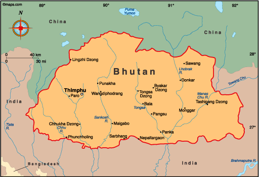
Map of Bhutan
Ruler: King
Jigme Khesar Namgyal Wangchukin (2006)
Prime Minister: Tshering Tobgay
(2013)
Total area: 18,147 sq mi (47,000 sq
km)
Population (2014 est.): 733,643
(growth rate: 1.13%); birth rate: 18.12/1000; infant mortality rate:
37.89/1000; life expectancy: 68.98
Capital and largest city (2011 est.):
Thimphu (official), 99,000
Monetary unit: Ngultrum
Languages:
Sharchhopka 28%, Dzongkha (official) 24%, Lhotshamkha 22%, other 26% (includes foreign languages) (2005 est.)
Ethnicity/race:
Ngalop (also known as Bhote) 50%, ethnic Nepalese 35%
(includes Lhotsampas - one of several Nepalese ethnic groups),
indigenous or migrant tribes 15%
National Holiday:
National Day, December 17
Religions:
Lamaistic Buddhist 75.3%, Indian- and Nepalese-influenced Hinduism 22.1%, other 2.6% (2005 est.)
Literacy rate: 52.8% (2005 est.)
Economic summary: GDP/PPP (2013 est.):
$5.235 billion; per capita $7,000. Real growth rate: 5.8%.
Inflation: 11% Unemployment: 2.1% (2013 est.) Arable
land: 2.49%. Agriculture: rice, corn, root crops, citrus,
foodgrains; dairy products, eggs. Labor force: 336,400; note:
Natural
resources: timber, hydropower, gypsum, calcium carbide.
Exports: $721.8 million (2012 est.): electricity (to
India), cardamom, gypsum, timber, handicrafts, cement, fruit, precious
stones, spices. Imports: $1.28 billion (2011 est.): fuel
and lubricants, grain, machinery and parts, vehicles, fabrics, rice.
Major trading partners: India, South Korea, Hong Kong (2013).
Communications:
Telephones: main lines in use: 27,000 (2012); mobile cellular:
560,000 (2012). Broadcast media: state-owned
TV station established in 1999; cable TV service offers dozens of Indian
and other international channels; first radio station, privately
launched in 1973, is now state-owned; 5 private radio stations are
currently broadcasting (2012). Internet
hosts: 14,590 (2012). Internet users: 50,000 (2009).
Transportation: Railways: 0 km.
Highways: total: 8,050 km;
(2003). Ports and harbors: none. Airports: 2 (2013
est.).
International disputes:
lacking any treaty describing the boundary, Bhutan and China
continue negotiations to establish a common boundary alignment to
resolve territorial disputes arising from substantial cartographic
discrepancies, the largest of which lie in Bhutan's northwest and along
the Chumbi salient.
-------------------- o --------------------
No comments:
Post a Comment