BRAZIL
Geography: Brazil covers nearly half of South America and is the continent's largest nation. It extends 2,965 mi (4,772 km) north-south, 2,691 mi (4,331 km) east-west, and borders every nation on the continent except Chile and Ecuador. Brazil may be divided into the Brazilian Highlands, or plateau, in the south and the Amazon River Basin in the north. Over a third of Brazil is drained by the Amazon and its more than 200 tributaries. The Amazon is navigable for ocean steamers to Iquitos, Peru, 2,300 mi (3,700 km) upstream. Southern Brazil is drained by the Plata system—the Paraguay, Uruguay, and Paraná rivers.
Government: Federal republic.
History: Brazil is the only Latin American nation that derives its language and culture from Portugal. The native inhabitants mostly consisted of the nomadic Tupí-Guaraní Indians. Adm. Pedro Alvares Cabral claimed the territory for Portugal in 1500. The early explorers brought back a wood that produced a red dye, pau-brasil, from which the land received its name. Portugal began colonization in 1532 and made the area a royal colony in 1549.
During the Napoleonic Wars, King João VI, fearing the advancing French armies, fled Portugal in 1808 and set up his court in Rio de Janeiro. João was drawn home in 1820 by a revolution, leaving his son as regent. When Portugal tried to reimpose colonial rule, the prince declared Brazil's independence on Sept. 7, 1822, becoming Pedro I, emperor of Brazil. Harassed by his parliament, Pedro I abdicated in 1831 in favor of his five-year-old son, who became emperor in 1840 (Pedro II). The son was a popular monarch, but discontent built up, and in 1889, following a military revolt, he abdicated. Although a republic was proclaimed, Brazil was ruled by military dictatorships until a revolt permitted a gradual return to stability under civilian presidents.
President Wenceslau Braz cooperated with the Allies and declared war on Germany during World War I. In World War II, Brazil again cooperated with the Allies, welcoming Allied air bases, patrolling the South Atlantic, and joining the invasion of Italy after declaring war on the Axis powers.
After a military coup in 1964, Brazil had a series of military governments. Gen. João Baptista de Oliveira Figueiredo became president in 1979 and pledged a return to democracy in 1985. The election of Tancredo Neves on Jan. 15, 1985, the first civilian president since 1964, brought a nationwide wave of optimism, but when Neves died several months later, Vice President José Sarney became president. Collor de Mello won the election of late 1989, pledging to lower hyperinflation with free-market economics. When Collor faced impeachment by Congress because of a corruption scandal in Dec. 1992 and resigned, Vice President Itamar Franco assumed the presidency.
A former finance minister, Fernando Cardoso, won the presidency in the Oct. 1994 election with 54% of the vote. Cardoso sold off inefficient government-owned monopolies in the telecommunications, electrical power, port, mining, railway, and banking industries.
In Jan. 1999, the Asian economic crisis spread to Brazil. Rather than prop up the currency through financial markets, Brazil opted to let the currency float, which sent the real plummeting—at one time as much as 40%. Cardoso was highly praised by the international community for quickly turning around his country's economic crisis. Despite his efforts, however, the economy remained sluggish throughout 2001, and the country also faced an energy crisis. The IMF offered Brazil an additional aid package in Aug. 2001. And in Aug. 2002, to ensure that Brazil would not be dragged down by neighboring Argentina's catastrophic economic problems, the IMF agreed to lend Brazil a phenomenal $30 billion over fifteen months.
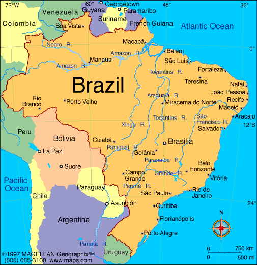
Map of Brazil
President: Dilma Rousseff (2011)
Land area: 3,265,059 sq mi (8,456,511 sq
km); total area: 3,286,470 sq mi (8,511,965 sq km)
Population (2012 est.): 205,716,890 (growth
rate: 1.1%); birth rate: 17.48/1000; infant mortality rate: 21.820.5/1000;
life expectancy: 72.79; density per sq km: 22
Capital (2009 est.):
Brasília, 3,789,000
Largest cities: São Paulo,
19,900,000; Rio de Janeiro,
11,836,000; Salvador,
2,590,400; Belo Horizonte, 5,736,000; Recife, 1,485,500; Porto Alegre,
4,034,000
Monetary unit: Real
National name: República
Federativa do Brasil
Ethnicity/race:
white 53.7%, mulatto (mixed white and black)
38.5%, black 6.2%, other (includes Japanese, Arab, Amerindian) 0.9%,
unspecified 0.7% (2000)
National Holiday:
Independence Day, September 7
Religion:
Roman Catholic 74%, Protestant 15%, Spiritualist
1%, none 7% (2000)
Literacy rate:
88.6% (2011 est.)
Economic summary:
GDP/PPP (2011 est.): $2.282 trillion; per capita $11,600.
Real growth rate: –2.7%. Inflation: 6.5%.
Unemployment: 6%. Arable land: 7%. Agriculture:
coffee, soybeans, wheat, rice, corn, sugarcane, cocoa, citrus; beef.
Labor force: 104.7 million; agriculture 20%, industry 14%,
services 66% (2011 est.). Industries: textiles, shoes,
chemicals, cement, lumber, iron ore, tin, steel, aircraft, motor
vehicles and parts, other machinery and equipment. Natural
resources: bauxite, gold, iron ore, manganese, nickel, phosphates,
platinum, tin, uranium, petroleum, hydropower, timber. Exports:
$250.8 billion f.o.b. (2011 est.): transport equipment, iron ore,
soybeans, footwear, coffee, autos. Imports: $219.6 billion
f.o.b. (2011 est.): machinery, electrical and transport equipment,
chemical products, oil. Major trading partners: U.S.,
Argentina, China, Netherlands, Germany, Mexico, Nigeria, Japan
(2005).
Communications: Telephones:
main lines in use: 42.141 million (2011); mobile cellular: 202.944
million (2011). Radio broadcast stations: AM 1,365, FM 296,
shortwave 161 (of which 91 are collocated with AM stations) (1999).
Television broadcast stations: 138 (1997). Internet
hosts: 23,790,000 (2011). Internet users: 75.892 million
(2011).
Transportation: Railways:
total: 28,538 km (2011). Highways: total:
1,751,868 km; paved: 96,353 km; unpaved: 1,655,515 km (2011).
Waterways: 50,000 km (most in areas remote from industry and
population) (2005). Ports and harbors: Gebig, Itaqui, Rio de
Janeiro, Rio Grande, San Sebasttiao, Santos, Sepetiba Terminal,
Tubarao, Vitoria. Airports: 4,072 (2011 est.).
International disputes: unruly region at
convergence of Argentina-Brazil-Paraguay borders is locus of money
laundering, smuggling, arms and illegal narcotics trafficking, and
fundraising for extremist organizations; uncontested dispute with
Uruguay over certain islands in the Quarai/Cuareim and Invernada
boundary streams and the resulting tripoint with Argentina; in 2004
Brazil submitted its claims to UNCLOS to extend its maritime
continental margin.
-------------------- o --------------------
No comments:
Post a Comment