BURUNDI
Geography: Wedged between Tanzania, the Democratic Republic of the Congo, and Rwanda in east-central Africa, Burundi occupies a high plateau divided by several deep valleys. It is equal in size to Maryland.
Government: Republic.
History: The original inhabitants of Burundi were the Twa, a Pygmy people who now make up only 1% of the population. Today the population is divided between the Hutu (approximately 85%) and the Tutsi, approximately 14%. While the Hutu and Tutsi are considered to be two separate ethnic groups, scholars point out that they speak the same language, have a history of intermarriage, and share many cultural characteristics. Traditionally, the differences between the two groups were occupational rather than ethnic. Agricultural people were considered Hutu, while the cattle-owning elite were identified as Tutsi. In theory, Tutsi were tall and thin, while Hutu were short and square, but in fact it is often impossible to tell one from the other. The 1933 requirement by the Belgians that everyone carry an identity card indicating tribal ethnicity as Tutsi or Hutu increased the distinction. Since independence, the landowning Tutsi aristocracy has dominated Burundi.
Burundi was once part of German East Africa. Belgium won a League of Nations mandate in 1923, and subsequently Burundi, with Rwanda, was transferred to the status of a United Nations trust territory. In 1962, Burundi gained independence and became a kingdom under Mwami Mwambutsa IV, a Tutsi. A Hutu rebellion took place in 1965, leading to brutal Tutsi retaliations. Mwambutsa was deposed by his son, Ntaré V, in 1966. Ntaré in turn was overthrown the same year in a military coup by Premier Michel Micombero, also a Tutsi. In 1970–1971, a civil war erupted, leaving more than 100,000 Hutu dead.
On Nov. 1, 1976, Lt. Col. Jean-Baptiste Bagaza led a coup and assumed the presidency. He suspended the constitution and announced that a 30-member Supreme Revolutionary Council would be the governing body. In Sept. 1987, Bagaza was overthrown by Maj. Pierre Buyoya, who became president. Ethnic hatred again flared in Aug. 1988, and about 20,000 Hutu were slaughtered. Buyoya, however, began reforms to heal the country's ethnic rift. The Burundi Democracy Front's candidate, Melchior Ndadaye, won the country's first democratic presidential elections, held on June 2, 1993. Ndadaye, the first Hutu to assume power in Burundi, was killed within months during a coup. The second Hutu president, Cyprien Ntaryamira, was killed on April 6, 1994, when a plane carrying him and the Rwandan president was shot down. As a result, Hutu youth gangs began massacring Tutsi; the Tutsi-controlled army retaliated by killing Hutus.
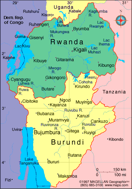
Map of Burundi
Republic of Burundi
President: Pierre Nkurunziza
(2005)
Land area: 9,903 sq mi (25,649 sq km);
total area: 10,745 sq mi (27,830 sq km)
Population (2014 est.): 10,395,931
(growth rate: 3.28%); birth rate: 42.33/1000; infant mortality rate:
63.44/1000; life expectancy: 59.55
Capital and largest city (2011 est.):
Bujumbura, 605,000
Other large city: Gitega,
45,700
Monetary unit: Burundi franc
National name: Republika y'u
Burundi
Languages:
Kirundi 29.7% (official), Kirundi and other language 9.1%,
French (official) and French and other language 0.3%, Swahili and
Swahili and other language 0.2% (along Lake Tanganyika and in the
Bujumbura area), English and English and other language 0.06%, more than
2 languages 3.7%, unspecified 56.9% (2008 est.)
Ethnicity/race:
Hutu (Bantu) 85%, Tutsi (Hamitic) 14%, Twa (Pygmy) 1%, Europeans 3,000, South Asians 2,000
National Holiday:
Independence Day, July 1
Religions:
Catholic 62.1%, Protestant 23.9% (includes Adventist 2.3%
and other Protestant 21.6%), Muslim 2.5%, other 3.6%, unspecified 7.9%
(2008 est.)
Literacy rate: 67.2% (2010 est.)
Economic summary: GDP/PPP (2013
est.): $5.75 billion; per capita $600. Real growth rate:
4.5%. Inflation: 9.3%. Unemployment: n.a.
Arable land: 33.06%. Agriculture: coffee, cotton, tea,
corn, sorghum, sweet potatoes, bananas, manioc (tapioca); beef,
milk, hides. Labor force: 4.245 million (2007); agriculture
93.6%, industry 2.3%, services 4.1% (2002 est.). Industries:
light consumer goods such as blankets, shoes, soap; assembly of
imported components; public works construction; food processing.
Natural resources: nickel, uranium, rare earth oxides, peat,
cobalt, copper, platinum (not yet exploited), vanadium, arable land,
hydropower, niobium, tantalum, gold, tin, tungsten, kaolin,
limestone. Exports: $122.8 million (2013 est.): coffee,
tea, sugar, cotton, hides. Imports: $867.2 million (2013
est.): capital goods, petroleum products, foodstuffs. Major
trading partners: Belgium, Pakistan, U.S., Rwanda,
U.K., Democratic Republic of the Congo, China, Egypt, India, Kenya, Tanzania, Italy, Uganda, Zambia (2012).
Communications: Telephones: main lines
in use: 17,400 (2012); mobile cellular: 2.247 million (2012). Broadcast media:
state-controlled La Radiodiffusion et Television Nationale de Burundi
(RTNB) operates the lone TV station and the only national radio network;
about 10 privately owned radio stations; transmissions of several
international broadcasters are available in Bujumbura (2007). Internet
hosts: 229 (2011). Internet users: 157,800 (2009).
Transportation: Railways: 0 km.
Highways: total: 12,322 km; paved: 1,286 (2004 est.). Waterways: mainly on Lake Tanganyika (2011).
Ports and harbors: Bujumbura. Airports: 7 (2013).
International disputes:
Burundi and Rwanda dispute two sq km (0.8 sq mi) of Sabanerwa, a farmed
area in the Rukurazi Valley where the Akanyaru/Kanyaru River shifted
its course southward after heavy rains in 1965; cross-border conflicts
persist among Tutsi, Hutu, other ethnic groups, associated political
rebels, armed gangs, and various government forces in the Great Lakes
region.
-------------------- o --------------------
No comments:
Post a Comment