CAMEROON
Geography: Cameroon is a Central African nation on the Gulf of Guinea, bordered by Nigeria, Chad, the Central African Republic, the Republic of Congo, Equatorial Guinea, and Gabon. It is nearly twice the size of Oregon. Mount Cameroon (13,350 ft; 4,069 m), near the coast, is the highest elevation in the country. The main rivers are the Benue, Nyong, and Sanaga.
Government: After a 1972 plebiscite, a unitary republic was formed out of East and West Cameroon to replace the former federal republic.
History: Bantu speakers were among the first groups to settle Cameroon, followed by the Muslim Fulani in the 18th and 19th centuries. The land escaped colonial rule until 1884, when treaties with tribal chiefs brought the area under German domination. After World War I, the League of Nations gave the French a mandate over 80% of the area, and the British 20% adjacent to Nigeria. After World War II, when the country came under a UN trusteeship in 1946, self-government was granted, and the Cameroon People's Union emerged as the dominant party by campaigning for reunification of French and British Cameroon and for independence. Accused of being under Communist control, the party waged a campaign of revolutionary terror from 1955 to 1958, when it was crushed. In British Cameroon, unification was also promoted by the leading party, the Kamerun National Democratic Party, led by John Foncha.
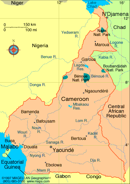
Map of Cameroon
Republic of Cameroon
President: Paul Biya (1982)
Prime Minister: Philemon Yang
(2009)
Land area: 181,251 sq mi (469,440 sq km);
total area: 183,567 sq mi (475,440 sq km)
Population (2014 est.): 23,130,708
(growth rate: 2.6%); birth rate: 36.58/1000; infant mortality rate:
55.1/1000; life expectancy: 57.35
Capital (2011):
Yaoundé, 2.432 million
Largest city: Douala, 2.449 million
Monetary unit: CFA Franc
National name: République du
Cameroun
Languages:
French, English (both official); 24 major
African language groups
Ethnicity/race:
Cameroon Highlanders 31%, Equatorial Bantu
19%, Kirdi 11%, Fulani 10%, Northwest Bantu 8%, Eastern Nigritic 7%,
other African 13%, non-African less than 1%
National Holiday:
Republic Day (National Day), May 20
Religions:
indigenous beliefs 40%, Christian 40%, Islam
20%
Literacy rate: 75.9% (2011 est.)
Economic summary: GDP/PPP (2013
est.): $53.16 billion; per capita $2,400. Real growth rate:
4.6%. Inflation: 2.6%. Unemployment: 30% (2011 est.).
Arable land: 13.04%. Agriculture: coffee, cocoa, cotton,
rubber, bananas, oilseed, grains, root starches; livestock; timber.
Labor force: 8.426 million; agriculture 70%, industry and
commerce 13%, other 17%. Industries: petroleum production and
refining, aluminum production, food processing, light consumer
goods, textiles, lumber, ship repair. Natural resources:
petroleum, bauxite, iron ore, timber, hydropower. Exports:
$6.002 billion (2013 est.): crude oil and petroleum products,
lumber, cocoa beans, aluminum, coffee, cotton. Imports:
$6.795 billion (2013 est.): machinery, electrical
equipment, transport equipment, fuel, food. Major trading
partners: Spain, Italy, France, U.S.,
Netherlands, Nigeria, Belgium, China, Portugal (2012).
Communications: Telephones: main lines
in use: 737,400 (2012); mobile cellular: 13.1 million (2012).
Broadcast media: government maintains tight
control over broadcast media; state-owned Cameroon Radio Television
(CRTV), broadcasting on both a TV and radio network, was the only
officially recognized and fully licensed broadcaster until August 2007
when the government finally issued licenses to 2 private TV broadcasters
and 1 private radio broadcaster; about 70 privately owned, unlicensed
radio stations operating but are subject to closure at any time; foreign
news services required to partner with state-owned national station
(2007). Internet
hosts: 10,201 (2012). Internet users: 749,600 (2009).
Transportation: Railways: total: 1,245
km (2011). Highways: total: 51,350 km (2011 est.). Waterways: (major
rivers in the south, such as the Wouri and the Sanaga, are largely
non-navigable; in the north, the Benue, which connects through Nigeria
to the Niger River, is navigable in the rainy season only to the port of
Garoua) (2010). Ports and
harbors: Douala (Wouri); Garoua (Benoue), Limboh Terminal. Airports: 33 (2013
est.).
International disputes:
Joint Border Commission with Nigeria reviewed 2002 ICJ ruling on the
entire boundary and bilaterally resolved differences, including June
2006 Greentree Agreement that immediately ceded sovereignty of the
Bakassi Peninsula to Cameroon with a full phase-out of Nigerian control
and patriation of residents in 2008; Cameroon and Nigeria agreed on
maritime delimitation in March 2008; sovereignty dispute between
Equatorial Guinea and Cameroon over an island at the mouth of the Ntem
River; only Nigeria and Cameroon have heeded the Lake Chad Commission's
admonition to ratify the delimitation treaty, which also includes the
Chad-Niger and Niger-Nigeria boundaries.
-------------------- o --------------------
No comments:
Post a Comment