CAPE VERDE
Geography: Cape Verde, only slightly larger than Rhode Island, is an archipelago in the Atlantic 385 mi (500 km) west of Senegal.
The islands are divided into two groups: Barlavento in the north, composed of Santo Antão (291 sq mi; 754 sq km), Boa Vista (240 sq mi; 622 sq km), São Nicolau (132 sq mi; 342 sq km), São Vicente (88 sq mi; 246 sq km), Sal (83 sq mi; 298 sq km), and Santa Luzia (13 sq mi; 34 sq km); and Sotavento in the south, consisting of São Tiago (383 sq mi; 992 sq km), Fogo (184 sq mi; 477 sq km), Maio (103 sq mi; 267 sq km), and Brava (25 sq mi; 65 sq km). The islands are mostly mountainous, with the land deeply scarred by erosion. There is an active volcano on Fogo.
Government: Republic.
History: Uninhabited on their discovery in 1456, the Cape Verde islands became part of the Portuguese empire in 1495. A majority of today's inhabitants are of mixed Portuguese and African ancestry.
Positioned on the great trade routes between Africa, Europe, and the New World, the islands became a prosperous center for the slave trade but suffered economic decline after the slave trade was abolished in 1876. In the 20th century, Cape Verde served as a shipping port.
In 1951, Cape Verde's status changed from a Portuguese colony to an overseas province, and in 1961 the inhabitants became full Portuguese citizens. An independence movement led by the African Party for the Independence of Guinea-Bissau (another former Portuguese colony) and Cape Verde (PAIGC) was founded in 1956. Following the 1974 coup in Portugal, after which Portugal began abandoning its colonial empire, the islands became independent (July 5, 1975).
On Jan. 13, 1991, the first multiparty elections since independence resulted in the ruling African Party for the Independence of Cape Verde (PAICV) losing its majority to the Movement for Democracy Party (MPD). The MPD candidate, Antonio Monteiro, won the subsequent presidential election, and was easily reelected in 1996. In 2001, Pedro Pires became president.
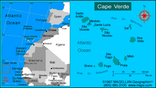
Map of Cape
Verde
President: Jorge Carlos Fonseca (2011)
Prime Minister: José Maria
Neves (2001)
Total area: 1,556 sq mi (4,030 sq km)
Population (2014 est.): 538,535 (growth
rate: 1.39%); birth rate: 20.72/1000; infant mortality rate:
24.28/1000; life expectancy: 71.57
Capital and largest city (2011 est.):
Praia, 132,000
Other large city: Mindelo,
66,100
Monetary unit: Cape Verdean escudo
National name: República de
Cabo Verde
Languages:
Portuguese (official), Crioulo (a blend of Portuguese and West African words)
Ethnicity/race:
Creole (mulatto) 71%, African 28%, European 1%
National Holiday:
Independence Day, July 5
Religion:
Roman Catholic 77.3%, Protestant 3.7% (includes Church
of the Nazarene 1.7%, Adventist 1.5%, Universal Kingdom of God .4%, and
God and Love .1%), other Christian 4.3% (includes Christian Rationalism
1.9%, Jehovah's Witness 1%, Assembly of God .9%, and New Apostolic .5%),
Muslim 1.8%, other 1.3%, none 10.8%, unspecified 0.7% (2010 est.)
Literacy rate: 84.9% (2011 est.)
Economic summary: GDP/PPP (2013
est.): $2.222 billion; per capita $4,400. Real growth rate:
1.5%. Inflation: 1.9%. Unemployment: 21% (2000 est.).
Arable land: 11.66%. Agriculture: bananas, corn, beans,
sweet potatoes, sugarcane, coffee, peanuts; fish. Labor force:
196,100 Industries: food and beverages, fish processing,
shoes and garments, salt mining, ship repair. Natural
resources: salt, basalt rock, limestone, kaolin, fish, clay,
gypsum. Exports: $159.9 million f.o.b. (2011 est.): fuel,
shoes, garments, fish, hides. Imports: $796.3 million
(2013 est.): foodstuffs, industrial products, transport equipment,
fuels. Major trading partners: Portugal, U.S.,
Netherlands, China, Spain, (2012).
Communications: Telephones: main lines
in use: 70,200 (2012); mobile cellular: 425,300 (2012). Radio
broadcast stations: AM 0, FM 15 (and 17 repeaters), shortwave 0
(2002). Broadcast media: state-run TV and
radio broadcast network plus a growing number of private broadcasters;
Portuguese public TV and radio services for Africa are available;
transmissions of a few international broadcasters are available (2007). Internet hosts: 38 (2012). Internet users:
150,000 (2009).
Transportation: Railways: total: 0 km.
Highways: total: 1,350 km; paved: 932 km; unpaved: 418 km
(2013). Waterways: none. Ports and harbors: Porto Grande. Airports: 9 (2013 est.).
International disputes: none.
-------------------- o --------------------
No comments:
Post a Comment