CENTRAL AFRICAN REPUBLIC
Geography: Situated about 500 mi (805 km) north of the equator, the Central African Republic is a landlocked nation bordered by Cameroon, Chad, the Sudan, the Democratic Republic of the Congo, and the Republic of Congo. The Ubangi and the Shari are the largest of many rivers.
Government: Republic.
History: From the 16th to 19th century, the people of this region were ravaged by slave traders. The Banda, Baya, Ngbandi, and Azande make up the largest ethnic groups.
The French occupied the region in 1894. As the colony of Ubangi-Shari, what is now the Central African Republic was united with Chad in 1905. In 1910 it was joined with Gabon and the Middle Congo to become French Equatorial Africa. After World War II a rebellion in 1946 forced the French to grant self-government. In 1958 the territory voted to become an autonomous republic within the French Community, and on Aug. 13, 1960, President David Dacko proclaimed the republic's independence from France. Dacko moved the country politically into Beijing's orbit, but he was overthrown in a coup on Dec. 31, 1965, by Col. Jean-Bédel Bokassa, army chief of staff.
On Dec. 4, 1976, the Central African Republic became the Central African Empire. Marshal Jean-Bédel Bokassa, who had ruled the republic since he took power in 1965, was declared Emperor Bokassa I. Brutality and excess characterized his regime. He was overthrown in a coup on Sept. 20, 1979. Former president David Dacko returned to power and changed the country's name back to the Central African Republic. An army coup on Sept. 1, 1981, deposed President Dacko again.
In 1991, President André Kolingba, under pressure, announced a move toward parliamentary democracy. In elections held in Aug. 1993, Prime Minister Ange-Félix Patassé defeated Kolingba. Part of Patassé's popularity rested on his pledge to pay the back salaries of the military and civil servants.
A 1994 economic upturn was too small to effectively improve the catastrophic financial condition of the nation. Patassé was unable to pay the salaries due to government workers, and the military revolted in 1996. At Patassé's request, French troops suppressed the uprising. In 1998 the United Nations sent an all-African peacekeeping force to the country. In elections held in Sept. 1999, amid widespread charges of massive fraud, Patassé easily defeated Kolingba. Patassé survived a coup attempt in May 2001, but two years later, in March 2003, he was overthrown by Gen. François Bozizé. After two years of military rule, presidential elections were held, and Bozizé won in what international monitors called a free and fair election.
Prime Minister Elie Dote and his government resigned in January 2008, a day before Parliament was set to debate a censure motion against him. Faustin Archange Touadéra was named as his successor.
The trial of Jean-Pierre Bemba, a former vice-president of Congo, began at the International Criminal Court in November 2010. He is accused of ordering his militia to commit war crimes and crimes against humanity, including rape, murder, and torture, in the Central African Republic in 2002 and 2003 during civil unrest that followed the attempted coup against Patassé.
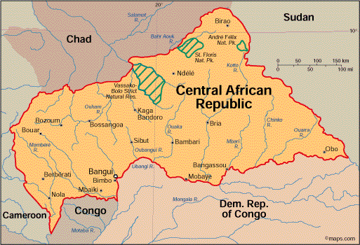
Map
of Central African Republic
President: Catherine Samba-Panza (interim; 2014)
Prime Minister: Mahamat Kamoun (2014)
Total area: 240,533 sq mi (622,980 sq km)
Population (2014 est.): 5,277,959
(growth rate: 2.13%); birth rate: 35.45/1000; infant mortality rate:
92.86/1000; life expectancy: 51.35
Capital and largest city (2011 est.):
Bangui, 740,000
Monetary unit: CFA Franc
National name: République
Centrafricaine
Languages:
French (official), Sangho (lingua franca,
national), tribal languages
Ethnicity/race:
Baya 33%, Banda 27%, Mandjia 13%, Sara 10%,
Mboum 7%, M'Baka 4%, Yakoma 4%, other 2%
National Holiday:
Republic Day, December 1
Religions:
indigenous beliefs 35%, Protestant and Roman
Catholic (both with animist influence) 25% each, Islam 15%
Literacy rate: 56.6% (2011 est.)
Economic summary: GDP/PPP $3.336
billion (2013 est.); per capita $700. Real growth rate: -14.5%.
Inflation: 7% (2013 est.). Unemployment: 8% (2001 est.). Arable land: 2.89%. Agriculture:
cotton, coffee, tobacco, manioc (tapioca), yams, millet, corn,
bananas; timber. Labor force: 2.082 million (2012) Industries: gold
and diamond mining, logging, brewing, textiles, footwear, assembly
of bicycles and motorcycles. Natural resources: diamonds,
uranium, timber, gold, oil, hydropower. Exports: $138.9 million (2013 est.): diamonds, timber, cotton, coffee, tobacco.
Imports: $218.6 million (2013 est.): food, textiles,
petroleum products, machinery, electrical equipment, motor vehicles,
chemicals, pharmaceuticals. Major trading partners: Belgium,
Democratic Republic of the Congo, France, Indonesia, China, Cameroon, South Korea (2012).
Communications: Telephones: main lines
in use: 5,600 (2012); mobile cellular: 1.07 million (2012). Broadcast media:
government-owned network, Radiodiffusion Television Centrafricaine,
provides domestic TV broadcasting; licenses for 2 private TV stations
are pending; state-owned radio network is supplemented by a small number
of privately owned broadcast stations as well as a few community radio
stations; transmissions of at least 2 international broadcasters are
available (2007). Internet hosts:
20 (2012). Internet users: 22,600 (2009).
Transportation: Railways: 0 km.
Roadways: total: 20,278 km (2010 est.). Waterways: 2,800 km (primarily on the
Oubangui and Sangha rivers) (2011). Ports and harbors:
Bangui, Nola. Airports: 39 (2013 est.).
International disputes: periodic
skirmishes over water and grazing rights among related pastoral
populations along the border with southern Sudan persist.
-------------------- o --------------------
No comments:
Post a Comment