CHAD
Geography: A landlocked country in north-central Africa, Chad is about 85% the size of Alaska. Its neighbors are Niger, Libya, the Sudan, the Central African Republic, Cameroon, and Nigeria. Lake Chad, from which the country gets its name, lies on the western border with Niger and Nigeria. In the north is a desert that runs into the Sahara.
Government: Republic.
History: The area around Lake Chad has been inhabited since at least 500 B.C. In the 8th century A.D. , Berbers began migrating to the area. Islam arrived in 1085, and by the 16th century a trio of rival kingdoms flourished: the Kanem-Bornu, Baguirmi, and Ouaddaï. During the years 1883–1893, all three kingdoms came under the rule of the Sudanese conqueror Rabih al-Zubayr. In 1900, Rabih was overthrown by the French, who absorbed these kingdoms into the colony of French Equatorial Africa, as part of Ubangi-Shari (now the Central African Republic), in 1913. In 1946, the territory, now known as Chad, became an autonomous republic within the French Community. An independence movement led by the first premier and president, François (later Ngarta) Tombalbaye, achieved complete independence on Aug. 11, 1960. Tombalbaye was killed in the 1975 coup and succeeded by Gen. Félix Malloum, who faced a Libyan-financed civil war throughout his tenure in office. In 1977, Libya seized a strip of Chadian land and launched an invasion two years later.
Nine rival groups meeting in Lagos, Nigeria, in March 1979 agreed to form a provisional government headed by Goukouni Oueddei, a former rebel leader. Fighting broke out again in Chad in March 1980, when Defense Minister Hissen Habré challenged Goukouni and seized the capital. Libyan president Muammar al-Qaddafi, in Jan. 1981, proposed a merger of Chad with Libya. The Libyan proposal was rejected and Libyan troops withdrew from Chad that year, but in 1983 they poured back into the northern part of the country in support of Goukouni. France, in turn, sent troops into southern Chad in support of Habré. Government troops then launched an offensive in early 1987 that drove the Libyans out of most of the country.
In 1990, Idriss Déby, a former defense minister and head of the Patriotic Salvation Movement, overthrew Habré, suspended the constitution, and dissolved the legislature. In 1994 a new constitution was drafted and an amnesty for political prisoners was declared. Déby won multiparty elections in 1996 and was reelected in 2001. His rule has been marked by repression and corruption. Déby has faced about a half-dozen insurgencies since taking office.
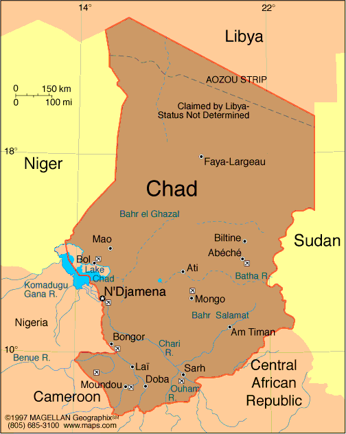
Map of Chad
President: Idriss Déby (1990)
Prime Minister: Kalzeube Pahimi Deubet
(2013)
Land area: 486,178 sq mi (1,259,201 sq
km); total area: 495,755 sq mi (1,284,000 sq km)
Population (2014): 11,412,107 (growth
rate: 1.92%); birth rate: 37.29/1000; infant mortality rate: 90.3/1000;
life expectancy: 49.44.
Capital and largest city (2011 est.):
N'Djamena, 1.079
Monetary unit: CFA Franc
National
name: République du Tchad
Languages:
French, Arabic (both official); Sara; more than
120 languages and dialects
Ethnicity/race:
Sara 27.7%, Arab 12.3%, Mayo-Kebbi 11.5%, Kanem-Bornou
9%, Ouaddai 8.7%, Hadjarai 6.7%, Tandjile 6.5%, Gorane 6.3%, Fitri-Batha
4.7%, other 6.4%, unknown 0.3% (1993 census)
National Holiday:
Independence Day, August 11
Religions:
Muslim 53.1%, Catholic 20.1%, Protestant 14.2%, animist 7.3%, other 0.5%, unknown 1.7%, atheist 3.1% (1993 census)
Literacy rate: 35.4% (2011
est.)
Economic summary: GDP/PPP
(2013 est.):$28 billion; per capita $2,500. Real growth
rate: 3.9%. Inflation: 4.5%. Unemployment: n.a.
Arable land: 3.82%. Agriculture: cotton, sorghum, millet,
peanuts, rice, potatoes, manioc (tapioca); cattle, sheep, goats,
camels. Labor force: 4.293 million (2007); agriculture 80%; industry and
services 20% (subsistence farming, herding, and fishing).
Industries: oil, cotton textiles, meatpacking, beer brewing,
natron (sodium carbonate), soap, cigarettes, construction
materials. Natural resources: petroleum (unexploited but
exploration under way), uranium, natron, kaolin, fish (Lake Chad),
gold, limestone, sand and gravel, salt. Exports: $3.865 billion
(2013 est.): cotton, cattle, gum arabic, oil. Imports:
$2.701 billion (2013 est.): machinery and transportation
equipment, industrial goods, foodstuffs, textiles. Major trading
partners: U.S., Saudi Arabia, China, France, Cameroon (2012).
Communications:
Telephones: main lines in use: 29,900 (2012); mobile cellular:
4.2 million (2012). Broadcast media: 1
state-owned TV station; state-owned radio network, Radiodiffusion
Nationale Tchadienne (RNT), operates national and regional stations;
about 10 private radio stations; some stations rebroadcast programs from
international broadcasters (2007). Internet
hosts: 6 (2012) . Internet users: 168,100 (2009).
Transportation: Railways: 0 km.
Highways: total: 40,000 km
(2011). Waterways: Chari and Legone rivers are navigable
only in wet season (2012). Ports and harbors: none.
Airports: 59 (2013).
International disputes:
since 2003, ad hoc armed militia groups and the Sudanese military have
driven hundreds of thousands of Darfur residents into Chad; Chad wishes
to be a helpful mediator in resolving the Darfur conflict, and in 2010
established a joint border monitoring force with Sudan, which has helped
to reduce cross-border banditry and violence; only Nigeria and Cameroon
have heeded the Lake Chad Commission's admonition to ratify the
delimitation treaty, which also includes the Chad-Niger and
Niger-Nigeria boundaries.
-------------------- o --------------------
No comments:
Post a Comment