CHILE
Geography: Situated south of Peru and west of Bolivia and Argentina, Chile fills a narrow 2,880-mi (4,506 km) strip between the Andes and the Pacific. One-third of Chile is covered by the towering ranges of the Andes. In the north is the driest place on Earth, the Atacama Desert, and in the center is a 700-mile-long (1,127 km) thickly populated valley with most of Chile's arable land. At the southern tip of Chile's mainland is Punta Arenas, the southernmost city in the world, and beyond that lies the Strait of Magellan and Tierra del Fuego, an island divided between Chile and Argentina. The southernmost point of South America is Cape Horn, a 1,390-foot (424 m) rock on Horn Island in the Wollaston group, which belongs to Chile. Chile also claims sovereignty over 482,628 sq mi (1,250,000 sq km) of Antarctic territory; the Juan Fernández Islands, about 400 mi (644 km) west of the mainland; and Easter Island, about 2,000 mi (3,219 km) west.
Government: Republic.
History: Chile was originally under the control of the Incas in the north and the nomadic Araucanos in the south. In 1541, a Spaniard, Pedro de Valdivia, founded Santiago. Chile won its independence from Spain in 1818 under Bernardo O'Higgins and an Argentinian, José de San Martin. O'Higgins, dictator until 1823, laid the foundations of the modern state with a two-party system and a centralized government.
The dictator from 1830 to 1837, Diego Portales, fought a war with Peru from 1836—1839 that expanded Chilean territory. Chile fought the War of the Pacific with Peru and Bolivia from 1879 to 1883, winning Antofagasta, Bolivia's only outlet to the sea, and extensive areas from Peru. Pedro Montt led a revolt that overthrew José Balmaceda in 1891 and established a parliamentary dictatorship lasting until a new constitution was adopted in 1925. Industrialization began before World War I and led to the formation of Marxist groups. Juan Antonio Ríos, president during World War II, was originally pro-Nazi but in 1944 led his country into the war on the side of the Allies.
In 1970, Salvador Allende became the first president in a non-Communist country freely elected on a Marxist program. Allende quickly established relations with Cuba and the People's Republic of China, introduced Marxist economic and social reforms, and nationalized many private companies, including U.S.-owned ones. In Sept. 1973, Allende was overthrown and killed in a military coup covertly sponsored by the CIA, ending a 46-year era of constitutional government in Chile.
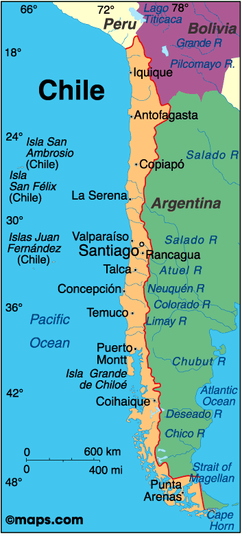
Map of Chile
President:
Michelle Bachelet (2014)
Land area: 289,112 sq mi (748,800 sq km);
total area: 292,260 sq mi (756,950 sq km)
Population (2014 est.): 17,363,894 (growth
rate: 0.84%); birth rate: 13.97/1000; infant mortality rate: 7.02/1000;
life expectancy: 78.44
Capital and largest city (2011 est.):
Santiago, 6.034 million
Other large cities:
Valparaiso 883,000; Concepcion 770,000 (2011)
Monetary unit: Chilean Peso
National
name: República de Chile
Language:
Spanish 99.5% (official), English 10.2%, indigenous 1%
(includes Mapudungun, Aymara, Quechua, Rapa Nui), other 2.3%,
unspecified 0.2%
note: shares sum to more than 100% because some respondents gave more than one answer on the census (2012 est.)
Ethnicity/race:
white and non-indigenous 88.9%, Mapuche 9.1%, Aymara
0.7%, other indigenous groups 1% (includes Rapa Nui, Likan Antai,
Quechua, Colla, Diaguita, Kawesqar, Yagan or Yamana), unspecified 0.3%
(2012 est.)
National Holiday:
Independence Day, September 18
Religions:
Roman Catholic 66.7%, Evangelical or Protestant 16.4%,
Jehovah's Witnesses 1%, other 3.4%, none 11.5%, unspecified 1.1% (2012
est.)
Literacy rate: 98.6% (2009
est.)
Economic summary: GDP/PPP
(2013 est.): $335.4 billion; per capita $19,100. Real growth
rate: 4.4%. Inflation: 1.7%. Unemployment: 6%.
Arable land: 1.74%. Agriculture: grapes, apples, pears,
onions, wheat, corn, oats, peaches, garlic, asparagus, beans; beef,
poultry, wool; fish; timber. Labor force: 8.367 million;
agriculture 13.2%, industry 23%, services 63.9% (2005).
Industries: copper, other minerals, foodstuffs, fish
processing, iron and steel, wood and wood products, transport
equipment, cement, textiles. Natural resources: copper, timber,
iron ore, nitrates, precious metals, molybdenum, hydropower.
Exports: $77.94 billion (2013 est.): copper, fruit, fish
products, paper and pulp, chemicals, wine. Imports: $75.7
billion (2013 est.): petroleum and petroleum products,
chemicals, electrical and telecommunications equipment, industrial
machinery, vehicles, natural gas. Major trading partners: U.S.,
Japan, China, South Korea, Brazil, Argentina (2012).
Communications:
Telephones: main lines in use: 3.276 million (2012); mobile
cellular: 24.13 million (2012). Broadcast media:
national and local terrestrial TV channels, coupled with extensive
cable TV networks; the state-owned Television Nacional de Chile (TVN)
network is self financed through commercial advertising revenues and is
not under direct government control; large number of privately owned TV
stations; about 250 radio stations (2007).
Internet hosts: 2.152 million (2012). Internet users: 7.009
million (2009).
Transportation:
Railways: total: 7,082 km (2008). Highways: total: 77,764
(2010). Waterways: 725
km. Ports and harbors: Coronel, Huasco, Lirquen, Puerto Ventanas, San Antonio, San Vicente, Valparaiso. Airports: 481 (2013 est.).
International disputes:
Chile and Peru rebuff Bolivia's reactivated claim to restore the
Atacama corridor, ceded to Chile in 1884, but Chile has offered instead
unrestricted but not sovereign maritime access through Chile to
Bolivian natural gas; Chile rejects Peru's unilateral legislation to
change its latitudinal maritime boundary with Chile to an equidistance
line with a southwestern axis favoring Peru; in October 2007, Peru took
its maritime complaint with Chile to the ICJ; territorial claim in
Antarctica (Chilean Antarctic Territory) partially overlaps Argentine
and British claims; the joint boundary commission, established by Chile
and Argentina in 2001, has yet to map and demarcate the delimited
boundary in the inhospitable Andean Southern Ice Field (Campo de Hielo
Sur).
-------------------- o --------------------
No comments:
Post a Comment