COLOMBIA
Geography: Colombia is bordered on the northwest by Panama, on the east by Venezuela and Brazil, and on the southwest by Peru and Ecuador. Through the western half of the country, three Andean ranges run north and south. The eastern half is a low, jungle-covered plain, drained by spurs of the Amazon and Orinoco Rivers, inhabited mostly by isolated tropical-forest Indian tribes. The fertile plateau and valley of the eastern range are the most densely populated parts of the country.
Government: Republic.
History: Little is known about the various Indian tribes who inhabited Colombia before the Spanish arrived. In 1510 Spaniards founded Darien, the first permanent European settlement on the American mainland. In 1538 they established the colony of New Granada, the area's name until 1861.
After a 14-year struggle, during which time Simón Bolívar's Venezuelan troops won the battle of Boyacá in Colombia on Aug. 7, 1819, independence was attained in 1824. Bolívar united Colombia, Venezuela, Panama, and Ecuador in the Republic of Greater Colombia (1819–1830), but he lost Venezuela and Ecuador to separatists. Two political parties dominated the region: the Conservatives believed in a strong central government and a powerful church; the Liberals believed in a decentralized government, strong regional power, and a less influential role for the church. Bolívar was himself a Conservative, while his vice president, Francisco de Paula Santander, was the founder of the Liberal Party.
Santander served as president between 1832 and 1836, a period of relative stability, but by 1840 civil war had erupted. Other periods of Liberal dominance (1849–1857 and 1861–1880), which sought to disestablish the Roman Catholic Church, were marked by insurrection. Nine different governments followed, each rewriting the constitution. In 1861, the country was called the United States of New Granada; in 1863 it became the United States of Colombia; and in 1885, it was named the Republic of Colombia.
In 1899, a brutal civil war broke out, the War of a Thousand Days, that lasted until 1902. The following year, Colombia lost its claims to Panama because it refused to ratify the lease to the United States of the Canal Zone. Panama declared its independence in 1903.
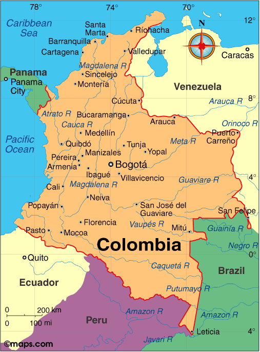
Map of Colombia
President: Juan Manuel Santos (2010)
Land area: 401,042 sq mi (1,038,699 sq
km); total area: 439,736 sq mi (1,138,910 sq km)
Population (2014 est.): 46,245,297 (growth
rate: 1.07%); birth rate: 16.73/1000; infant mortality rate: 15.02/1000;
life expectancy: 75.25
Capital and largest city (2011 est.):
Santafé de Bogotá, 8.743 million
Other large cities: Medellín, 3,497,800; Cali, 2,352,000;
Barranquilla, 1,836,000; Bucaramanga 1,065,000
Monetary unit: Colombian
Peso
National
name: República de Colombia
Language:
Spanish
Ethnicity/race:
mestizo 58%, white 20%, mulatto 14%, black 4%,
mixed black-Amerindian 3%, Amerindian 1%
National Holiday:
Independence Day, July 20
Religion:
Roman Catholic 90%, other 10%
Literacy rate: 93.6% (2011 est.)
Economic summary: GDP/PPP (2013 est.):
$526.5 billion; per capita $11,100. Real growth rate: 4.2%.
Inflation: 2.2%. Unemployment: 9.7%. Arable land:
1.84%. Agriculture: coffee, cut flowers, bananas, rice,
tobacco, corn, sugarcane, cocoa beans, oilseed, vegetables; forest
products; shrimp. Labor force: 23.75 million (2011);
agriculture 17%, industry 21%, services 62% (2011 est.).
Industries: textiles, food processing, oil, clothing and
footwear, beverages, chemicals, cement; gold, coal, emeralds.
Natural resources: petroleum, natural gas, coal, iron ore,
nickel, gold, copper, emeralds, hydropower. Exports: $58.7
billion (2013 est.): petroleum, coffee, coal, apparel, bananas,
cut flowers. Imports: $53.5 billion (2013 est.):
industrial equipment, transportation equipment, consumer goods,
chemicals, paper products, fuels, electricity. Major trading
partners: U.S., Venezuela, China, Mexico, Brazil, Netherlands, Panama, Spain (2012).
Communications: Telephones:
main lines in use: 6.291 million (2012); mobile cellular: 49.066 million
(2012). Broadcast media: combination of
state-owned and privately owned broadcast media provide service; more
than 500 radio stations and many national, regional, and local TV
stations (2007). Internet hosts: 4,.41 million (2012).
Internet users: 22.538 million (2009).
Transportation: Railways: total: 874 km
(2008). Highways: total: 141,374 km; (2010). Waterways: 24,725 km (2012). Ports and
harbors: Barranquilla, Buenaventura, Cartagena, Muelles El Bosque,
Puerto Bolivar, Santa Marta, Turbo. Airports: 836 (2013
est.).
International disputes:
in December 2007, ICJ allocated San Andres, Providencia, and
Santa Catalina islands to Colombia under 1928 Treaty but did not rule on
82 degrees W meridian as maritime boundary with Nicaragua; managed
dispute with Venezuela over maritime boundary and
Venezuelan-administered Los Monjes Islands near the Gulf of Venezuela;
Colombian-organized illegal narcotics, guerrilla, and paramilitary
activities penetrate all neighboring borders and have caused Colombian
citizens to flee mostly into neighboring countries; Colombia, Honduras,
Nicaragua, Jamaica, and the US assert various claims to Bajo Nuevo and
Serranilla Bank.
-------------------- o --------------------
No comments:
Post a Comment