COMOROS
Geography: The Comoros Islands—Grande Comoro (Ngazidja), Anjouan, Mohéli, and Mayotte (which is not part of the country and retains ties to France)—constitute an archipelago of volcanic origin in the Indian Ocean, 190 mi off the coast of Mozambique.
Government: Emerging republic.
History: Comoros was frequented by travelers from Africa, Madagascar, Indonesia, and Arabia before the first Europeans encountered the islands. Arabic influence has been the strongest.
France colonized Mayotte in 1843 and by 1904 had annexed the remainder of the archipelago. In a 1974 referendum, 95% of the population voted for independence. The exception was Mayotte, which, with its Christian majority, voted against joining the other mainly Islamic islands in independence. Today it remains a French overseas territory.
The remaining Comoros Islands declared themselves independent on July 6, 1975, with Ahmed Abdallah as president. A month after independence, he was overthrown by Justice Minister Ali Soilih. This was only the beginning of Comoros's chronic instability: the country has gone through more than 20 coups since independence and has experienced several attempts at secession. Orchestrating at least four of these coups was a group of white mercenaries known as Les Affreux (The Terrible Ones), and their notorious leader, Frenchman “Colonel” Bob Denard. Denard fled Comoros in 1989, when 3,000 French soldiers were sent after him.
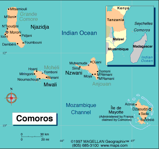
Map of Comoros
President:
Ikililou Dhoinine (2011)
Total area: 838 sq mi (2,170 sq km)
Population (2014 est.): 766,865 (growth
rate: 1.87%); birth rate: 29.0549/1000; infant mortality rate: 65.31/1000;
life expectancy: 63.48
Capital and largest city (2011 est.):
Moroni (on Grande Comoro), 54,000
Monetary unit: Franc
National
Name: Union des Comores
Languages:
Arabic and French (both official), Shikomoro
(Swahili/Arabic blend)
Ethnicity/race:
Antalote, Cafre, Makoa, Oimatsaha,
Sakalava
National Holiday:
Independence Day, July 6
Religions:
Sunni Muslim 98%, Roman Catholic 2%
Literacy rate: 75.5% (2011 est.)
Economic summary: GDP/PPP: (2013 est.)
$911 million; per capita $1,300. Real growth rate: 3.5%.
Inflation: 2.5%. Unemployment: 20% (2012 est.). Arable
land: 44.06%. Agriculture: vanilla, cloves, perfume essences,
copra, coconuts, bananas, cassava (tapioca). Labor force:
233,500 (2011 est.): agriculture 80%, industry and services 20% (1996).
Industries: tourism, perfume distillation. Natural
resources: negl. Exports: $19.7 million (2011 est.):
vanilla, ylang-ylang (perfume essence), cloves, copra. Imports:
$208.8 million (2013 est.): rice and other foodstuffs,
consumer goods, petroleum products, cement, transport equipment.
Major trading partners: France, Singapore, Turkey,
Kenya, UAE, India, Netherlands, Pakistan
(2012).
Communications: Telephones:
main lines in use: 24,000 (2012); mobile cellular: 250,000 (2012).
Broadcast media: national state-owned TV
station and a TV station run by Anjouan regional government; national
state-owned radio; regional governments on the islands of Grande Comore
and Anjouan each operate a radio station; a few independent and small
community radio stations operate on the islands of Grande Comore and
Moheli, and these two islands have access to Mayotte Radio and French TV
(2007). Internet hosts: 14
(2012). Internet users: 24,300 (2009).
Transportation: Railways: 0 km. Highways:
total: 880 km; paved: 673 km; unpaved: 207 km (2002 est.).
Ports and harbors: Moroni, Moutsamoudou. Airports: 4
(2013 est.).
International disputes:
claims French-administered Mayotte and challenges France's and
Madagascar's claims to Banc du Geyser, a drying reef in the Mozambique
Channel; in May 2008, African Union forces were called in to assist the
Comoros military recapture Anjouan Island from rebels who seized it in
2001.
-------------------- o --------------------
No comments:
Post a Comment