CONGO, DEMOCRATIC REPUBLIC
Geography: The Congo, in west-central Africa, is bordered by the Republic of Congo, the Central African Republic, the Sudan, Uganda, Rwanda, Burundi, Tanzania, Zambia, Angola, and the Atlantic Ocean. It is one-quarter the size of the U.S. The principal rivers are the Ubangi and Bomu in the north and the Congo in the west, which flows into the Atlantic. The entire length of Lake Tanganyika lies along the eastern border with Tanzania and Burundi.
Government: Transitional government.
History: Formerly the Belgian Congo, this territory was inhabited by ancient Negrito peoples (Pygmies), who were pushed into the mountains by Bantu and Nilotic invaders. The American correspondent Henry M. Stanley navigated the Congo River in 1877 and opened the interior to exploration. Commissioned by King Leopold II of the Belgians, Stanley made treaties with native chiefs that enabled the king to obtain personal title to the territory at the Berlin Conference of 1885.
Leopold accumulated a vast personal fortune from ivory and rubber through Congolese slave labor; 10 million people are estimated to have died from forced labor, starvation, and outright extermination during Leopold's colonial rule. His brutal exploitation of the Congo eventually became an international cause célèbre, prompting Belgium to take over administration of the Congo, which remained a colony until agitation for independence forced Brussels to grant freedom on June 30, 1960. In elections that month, two prominent nationalists won: Patrice Lumumba of the leftist Mouvement National Congolais became prime minister and Joseph Kasavubu of the ABAKO Party became head of state.
But within weeks of independence, the Katanga Province, led by Moise Tshombe, seceded from the new republic, and another mining province, South Kasai, followed. Belgium sent paratroopers to quell the civil war, and the United Nations flew in a peacekeeping force.
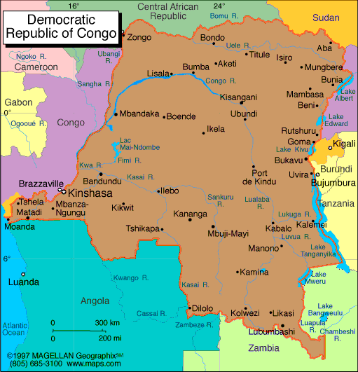
Map of Congo,
Democratic Republic
President: Joseph Kabila (2001)
Prime Minister: Augustin Matata Ponyo Mapon
(2012)
Land area: 875,520 sq mi (2,267,599 sq km);
total area: 905,568 sq mi (2,345,410 sq km)
Population (2014 est.): 77,433,744
(growth rate: 2.5%); birth rate: 35.62/1000; infant mortality rate:
73.15/1000; life expectancy: 56.54
Capital and largest city (2011 est.):
Kinshasa, 8.798 million
Other large cities: Lubumbashi,
1.556 million; Mbuji-Mayi, 1.504 million; Kananga 888,000; Kisangani 820,000
Monetary unit: Congolese franc
National Name: Republique
Democratique du Congo
Languages:
French (official), Lingala, Kingwana, Kikongo,
Tshiluba
Ethnicity/race:
With over 200 African ethnic groups, the
majority are Bantu; the four largest tribes—Mongo, Luba, Kongo
(all Bantu), and the Mangbetu-Azande (Hamitic)—make up about
45% of the population
National Holiday:
Independence Day, June 30
Religions:
Roman Catholic 50%, Protestant 20%,
Kimbanguist 10%, Islam 10%; other syncretic and indigenous 10%
Literacy rate: 66.8% (2010 est.)
Economic summary: GDP/PPP (2013
est.): $29.39 billion; per capita $400. Real growth rate:
6.2%. Inflation: 7.1% (2013 est.). Unemployment: n.a.
Arable land: 2.9%. Agriculture:
coffee, sugar, palm oil, rubber, tea, cotton, cocoa, quinine, cassava
(manioc), bananas, plantains, peanuts, root crops, corn, fruits; wood
products. Labor force: 35.18 million (2013)
Industries: mining (copper, cobalt, gold,
diamonds, coltan, zinc, tin, tungsten), mineral processing, consumer
products (textiles, plastics, footwear, cigarettes), metal products,
processed foods and beverages, timber, cement, commercial ship repair. Natural resources: cobalt,
copper, niobium, tantalum, petroleum, industrial and gem diamonds,
gold, silver, zinc, manganese, tin, uranium, coal, hydropower, timber. Exports: $9.936 billion (2013
est.): diamonds, copper, gold, cobalt, wood products, crude oil, coffee. Imports:
$8.924 billion (2013 est.): foodstuffs, mining and other
machinery, transport equipment, fuels. Major trading
partners: Belgium, China, South Africa, France,
Zambia, Kenya, Zimbabwe (2012).
Communications: Telephones: main lines
in use: 58,200 (2012); mobile cellular: 19.487 million (2012).
Radio broadcast stations: AM 3, FM 11, shortwave 2 (2001).
Television broadcast stations: 4 (2001). Internet
hosts: 2,515 (2012). Internet users: 290,000 (2008).
Transportation: Railways: total: 4,007
km (2008). Highways: total: 153,497 km; paved: 2,794 km;
unpaved: 150,703 km (2004). Waterways: 15,000 km (navigation
on the Congo curtailed by fighting) (2011). Ports and
harbors: Banana, Boma, Bukavu, Bumba, Goma, Kalemie, Kindu,
Kinshasa, Kisangani, Matadi, Mbandaka. Airports: 198 (2013
est.).
International disputes:
heads of the Great Lakes states and UN pledged in 2004 to abate tribal,
rebel, and militia fighting in the region, including northeast Congo,
where the UN Organization Mission in the Democratic Republic of the
Congo (MONUC), organized in 1999, maintains over 16,500 uniformed
peacekeepers; members of Uganda's Lords Resistance Army forces continue
to seek refuge in Congo's Garamba National Park as peace talks with the
Uganda government evolve; the location of the boundary in the broad
Congo River with the Republic of the Congo is indefinite except in the
Pool Malebo/Stanley Pool area; Uganda and DRC dispute Rukwanzi Island in
Lake Albert and other areas on the Semliki River with hydrocarbon
potential; boundary commission continues discussions over
Congolese-administered triangle of land on the right bank of the
Lunkinda River claimed by Zambia near the DRC village of Pweto; DRC
accuses Angola of shifting monuments.
-------------------- o --------------------
No comments:
Post a Comment