CONGO,
REPUBLIC
Geography: The Congo is situated in west-central Africa astride the equator. It borders Gabon, Cameroon, the Central African Republic, the Democratic Republic of the Congo, and the Angola exclave of Cabinda, with a short stretch of coast on the South Atlantic. Its area is nearly three times that of Pennsylvania. Most of the inland is tropical rain forest, drained by tributaries of the Congo River.
Government: Dictatorship.
History: In precolonial times, the region now called the Republic of Congo was dominated by three kingdoms: Kongo (originating about 1000), the Loango (flourishing in the 17th century), and Tio. After the Portuguese located the Congo River in 1482, commerce was carried on with the tribes, especially the slave trade.
The Frenchman Pierre Savorgnan de Brazza signed a treaty with Makoko, ruler of the Bateke people, in 1880, thus establishing French control. It was first called French Congo, and after 1905 Middle Congo. With Gabon and Ubangi-Shari, it became the colony of French Equatorial Africa in 1910. Abuse of laborers led to public outcry against the French colonialists as well as rebellions among the Congolese, but the exploitation of the native workers continued until 1930. During World War II, the colony joined Chad in supporting the Free French cause against the Vichy government. The Congo proclaimed its independence without leaving the French Community in 1960, calling itself the Republic of Congo.
The Congo's second president, Alphonse Massemba-Débat, instituted a Marxist-Leninist government. In 1968, Maj. Marien Ngouabi overthrew him but kept the Congo on a Socialist course. He was sworn in for a second five-year term in 1975. A four-man commando squad assassinated Ngouabi on March 18, 1977. Col. Joachim Yhombi-Opango, army chief of staff, assumed the presidency on April 4. Yhombi-Opango resigned on Feb. 4, 1979, and was replaced by Col. Denis Sassou-Nguesso.
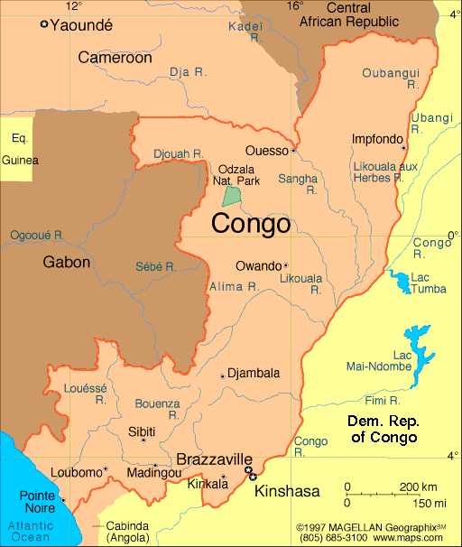
Map of Congo,
Republic
President: Denis Sassou-Nguesso
(1997)
Prime Minister: Denis Sassou-Nguesso
Land area: 131,853 sq mi (341,499 sq km);
total area: 132,047 sq mi (342,000 sq km)
Population (2014 est.): 4,662,446
(growth rate: 1.94%); birth rate: 36.59/1000; infant mortality rate:
59.34/1000; life expectancy: 58.52
Capital and largest city (2011 est.):
Brazzaville, 1.611
Other large city: Pointe-Noire,
834,000
Monetary unit: CFA Franc
National name: République du
Congo
Current government officials
Languages:
French (official), Lingala, Monokutuba,
Kikongo, many local languages and dialects
Ethnicity/race:
Kongo 48%, Sangha 20%, M'Bochi 12%, Teke 17%,
Europeans and other 3%
National Holiday:
Independence Day, August 15
Religions:
Roman Catholic 33.1%, Awakening Churches/Christian
Revival 22.3%, Protestant 19.9%, Salutiste 2.2%, Muslim 1.6%,
Kimbanguiste 1.5%, other 8.1%, none 11.3% (2010 est.)
Literacy rate: 83.8% (2003 est.)
Economic summary: GDP/PPP (2013
est.): $20.26 billion; per capita $4,800. Real growth rate:
5.8%. Inflation: 1.7%. Unemployment: 53% (2012). Arable
land: 1.46%. Agriculture: cassava (tapioca), sugar, rice,
corn, peanuts, vegetables, coffee, cocoa; forest products. Labor
force: 2.89 million (2011) Industries: petroleum extraction, cement,
lumber, brewing, sugar, palm oil, soap, flour, cigarettes.
Natural resources: petroleum, timber, potash, lead, zinc,
uranium, copper, phosphates, natural gas, hydropower.
Exports: $9.912 billion (2013 est.): petroleum,
lumber, plywood, sugar, cocoa, coffee, diamonds. Imports:
$4.297 billion (2013 est.): capital equipment, construction
materials, foodstuffs. Major trading partners: China,
U.S., France, Belgium, India, Australia, Spain, Italy, Netherlands
(2004).
Communications: Telephones: main lines
in use: 14,900 (2012); mobile cellular: 4.283 million (2012). Broadcast media:
1 state-owned TV and 3 state-owned radio stations; several privately
owned TV and radio stations; satellite TV service is available;
rebroadcasts of several international broadcasters are available (2007).
Internet
hosts: 45 (2012). Internet users: 245,200 (2009).
Transportation: Railways: total: 886 km
(2008). Highways: total: 17,289 km; (2004 est.). Waterways:
1,120 km (commercially navigable on Congo and Oubanqui rivers above
Brazzaville; there are many ferries across the river to Kinshasa; the
Congo south of Brazzaville-Kinshasa to the coast is not navigable
because of rapids, thereby necessitating a rail connection to Pointe
Noire; other rivers are used for local traffic only) (2011). Ports and harbors: Brazzaville,
Djeno, Impfondo, Ouesso, Oyo, Pointe-Noire. Airports: 27
(2013 est.).
International disputes:
the location of the boundary in the broad Congo River with the
Democratic Republic of the Congo is undefined except in the Pool
Malebo/Stanley Pool area.
-------------------- o --------------------
No comments:
Post a Comment