CÔTE D'IVOIRE
Geography: Côte d'Ivoire (also known as the Ivory Coast), in western Africa on the Gulf of Guinea, is a little larger than New Mexico. Its neighbors are Liberia, Guinea, Mali, Burkina Faso, and Ghana. The country consists of a coastal strip in the south, dense forests in the interior, and savannas in the north.
Government: Republic.
History: Côte d'Ivoire was originally made up of numerous isolated settlements; today it represents more than sixty distinct tribes, including the Baoule, Bete, Senoufou, Agni, Malinke, Dan, and Lobi. Côte d'Ivoire attracted both French and Portuguese merchants in the 15th century who were in search of ivory and slaves. French traders set up establishments early in the 19th century, and in 1842, the French obtained territorial concessions from local tribes, gradually extending their influence along the coast and inland. The area was organized as a territory in 1893, became an autonomous republic in the French Union after World War II, and achieved independence on Aug. 7, 1960. Côte d'Ivoire formed a customs union in 1959 with Dahomey (Benin), Niger, and Burkina Faso. The nation's economy is one of the most developed in sub-Saharan Africa. It is the world's largest exporter of cocoa and one of the largest exporters of coffee.
From independence until his death in 1993, Felix Houphouët-Boigny served as president. Massive protests by students, farmers, and professionals forced the president to legalize opposition parties and hold the first contested presidential election in Oct. 1990, which Houphouët-Boigny won with 81% of the vote.
Beginning in Sept. 1998, thousands of demonstrators protested a constitutional revision that granted President Henri Konan Bédié greatly enhanced powers. Bédié also promoted the concept of ivoirité, which, roughly translated, means “pure Ivoirian pride.” Although its defenders describe ivoirité as a term of positive national pride, it has led to dangerous xenophobia, with numerous ethnic Malians and Burkinans driven out of the country in 1999.
President Bédié was overthrown in the country's first military coup in Dec. 1999, and Gen. Robert Guei assumed control of the country. As a result, the majority of foreign aid to the country ceased.
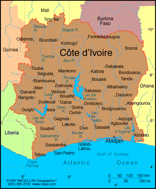
Map of
Côte d'Ivoire
President: Alassane Ouattara (2010)
Prime Minister:
Daniel Kablan Duncan (2012)
Land area: 122,780 sq mi (318,000 sq km);
total area: 124,502 sq mi (322,460 sq km)
Population (2014 est.): 22,848,945 (growth
rate: 1.96%); birth rate: 29.25/1000; infant mortality rate: 60.16/1000;
life expectancy: 58.01
Capital (2011 est.):
Yamoussoukro (official), 966,000; Largest
city and administrative center: Abidjan, 4.288 million
Monetary unit:
CFA Franc
National name: République de
Côte d'lvoire
Languages:
French (official) and African languages (Dioula
esp.)
Ethnicity/race:
Akan 42.1%, Voltaiques (Gur) 17.6%, Northern
Mandes 16.5%, Krous 11%, Southern Mandes 10%, other 2.8% (includes
130,000 Lebanese and 14,000 French) (1998)
National Holiday:
Independence Day, August 7
Religions:
Muslim 38.6%, Christian 32.8%, indigenous 11.9%, none 16.7% (2008 est.)
note: the majority of foreigners (migratory workers) are Muslim (70%) and Christian (20%)
Literacy
rate: 56.9% (2011 est.)
Economic
summary: GDP/PPP (2013 est.): $43.67 billion; per capita
$1,800. Real growth rate: 8%. Inflation: 2.9%.
Unemployment: n.a.. Arable land: 8.99%. Agriculture:
coffee, cocoa beans, bananas, palm kernels, corn, rice, manioc
(tapioca), sweet potatoes, sugar, cotton, rubber; timber. Labor
force: 7.928 million. Industries: foodstuffs, beverages;
wood products, oil refining, truck and bus assembly, textiles,
fertilizer, building materials, electricity, ship construction and
repair. Natural resources: petroleum, natural gas, diamonds,
manganese, iron ore, cobalt, bauxite, copper, hydropower.
Exports: $12.96 billion (2013 est.): cocoa, coffee,
timber, petroleum, cotton, bananas, pineapples, palm oil, fish.
Imports: $9.859 billion (2013 est.): fuel, capital
equipment, foodstuffs. Major trading partners: France,
Netherlands, U.S., Nigeria, Germany, Canada, China (2012).
Communications: Telephones: main lines in
use: 268,000 (2012); mobile cellular: 19.827 million (2011). Broadcast media:
2 state-owned TV stations; no private terrestrial TV stations, but
satellite TV subscription service is available; 2 state-owned radio
stations; some private radio stations; transmissions of several
international broadcasters are available (2007). Internet hosts: 9,115
(2012). Internet users: 967,300 (2009).
Transportation: Railways: total: 660 km
(2007). Roadways: total: 81,996 km (2007 est.). Waterways: 980 km (navigable rivers,
canals, and numerous coastal lagoons) (2011). Ports and
harbors: Abidjan, Aboisso, San-Pedro. Airports: 27
(2013 est.).
International disputes:
disputed maritime border between Cote d'Ivoire and Ghana.
-------------------- o --------------------
No comments:
Post a Comment