EAST TIMOR
Geography: East Timor is located in the eastern part of Timor, an island in the Indonesian archipelago that lies between the South China Sea and the Indian Ocean. East Timor includes the enclave of Oecussi, which is located within West Timor (Indonesia). After Indonesia, East Timor's closest neighbor is Australia, 400 mi to the south. It is semiarid and mountainous.
Government: Republic.
History: Timor was first colonized by the Portuguese in 1520. The Dutch, who claimed many of the surrounding islands, took control of the western portion of the island in 1613. Portugal and the Netherlands fought over the island until an 1860 treaty divided Timor, granting Portugal the eastern half of the island as well as the western enclave of Oecussi (the first Portuguese settlement on the island). Australia and Japan fought each other on the island during World War II; nearly 50,000 East Timorese died during the subsequent Japanese occupation.
In 1949, the Netherlands gave up its colonies in the Dutch East Indies, including West Timor, and the nation of Indonesia was born. East Timor remained under Portuguese control until 1975, when the Portuguese abruptly pulled out after 455 years of colonization. The sudden Portuguese withdrawal left the island vulnerable. On July 16, 1976, nine days after the Democratic Republic of East Timor was declared an independent nation, Indonesia invaded and annexed it. Although no country except Australia officially recognized the annexation, Indonesia's invasion was sanctioned by the United States and other western countries, who had cultivated Indonesia as a trading partner and cold-war ally (Fretilin, the East Timorese political party spearheading independence, was Marxist at the time).
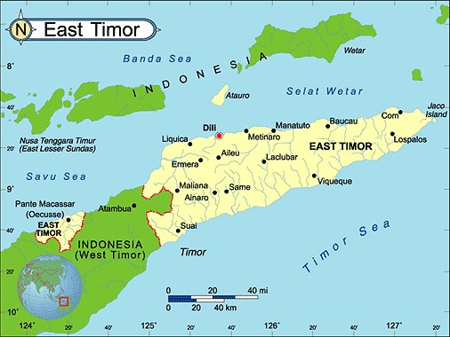
Map of East
Timor
President: Taur Matan Ruak (2012)
Prime Minister: Xanana Gusmão
(2007)
Total area: 5,641 sq mi (14,609 sq
km)
Population (2010 est.): 1,154,625
(growth rate: 2.0%); birth rate: 25.9/1000; infant mortality rate:
39.3/1000; life expectancy: 67.6; density per sq km: 75
Capital and largest city (2003 est.):
Dili, 50,800
Monetary unit: U.S. dollar
National name: Republika
Demokratika Timor Lorosa'e/Republica Democratica de Timor-Leste
Languages:
Tetum, Portuguese (official); Bahasa Indonesia,
English; other indigenous languages, including Tetum, Galole, Mambae,
and Kemak
Ethnicity/race:
Austronesian (Malayo-Polynesian), Papuan, small
Chinese minority
National Holiday:
Independence Day, November 28
Religions:
Roman Catholic 90%, Islam 4%, Protestant 3%,
Hindu 0.5%, Buddhist, animist (1992 est.)
Literacy rate: 58.6% (2002)
Economic summary: GDP/PPP (2009 est.):
$2.74 billion; per capita $2,400. Real growth rate: 7.2%.
Inflation: 1.4%. Unemployment: 20% estimated;
note: unemployment in urban areas reached 20%; data do not include
underemployed (2001 est.). Arable land: 5%. Agriculture:
coffee, rice, corn, cassava, sweet potatoes, soybeans, cabbage,
mangoes, bananas, vanilla. Labor force: n.a. Industries:
printing, soap manufacturing, handicrafts, woven cloth. Natural
resources: gold, petroleum, natural gas, manganese, marble.
Exports: $10 million; note: excludes oil (2005 est.): coffee,
sandalwood, marble; note: potential for oil and vanilla exports.
Imports: $202 million (2004 est.): food, gasoline, kerosene,
machinery. Major trading partner: Indonesia (2004).
Communications: Telephones: main lines in
use: n.a.; mobile cellular: n.a.. Radio broadcast stations:
n.a. Television broadcast stations: n.a. Internet hosts:
68 (2006) Internet users: 1000 (2004)
Transportation: Railways: total: 0 km.
Highways: total: 5,000 km; paved: 2,500 km; unpaved: 2,500 km
(2005). Waterways: n.a. Ports and harbors: n.a.
Airports: 8 (2006 est.).
International disputes: UN Mission of Support
in East Timor (UNMISET) has maintained about a thousand peacekeepers
in East Timor since 2002; East Timor-Indonesia Boundary Committee
continues to meet, survey, and delimit the land boundary, but several
sections of the boundary especially around the Oekussi enclave remain
unresolved; Indonesia and East Timor contest the sovereignty of the
uninhabited coral island of Palau Batek/Fatu Sinai, which prevents
delimitation of the northern maritime boundaries; many of 28,000 East
Timorese refugees still residing in Indonesia in 2003 have returned,
but many continue to refuse repatriation; East Timor and Australia
continue to meet but disagree over how to delimit a permanent maritime
boundary and share unexploited potential petroleum resources that fall
outside the Joint Petroleum Development Area covered by the 2002 Timor
Sea Treaty; dispute with Australia also hampers creation of a southern
maritime boundary with Indonesia.
-------------------- o --------------------
No comments:
Post a Comment