ECUADOR
Geography: Ecuador, about equal in area to Nevada, is in the northwest part of South America fronting on the Pacific. To the north is Colombia and to the east and south is Peru. Two high and parallel ranges of the Andes, traversing the country from north to south, are topped by tall volcanic peaks. The highest is Chimborazo at 20,577 ft (6,272 m). The Galápagos Islands (or Colón Archipelago: 3,029 sq mi; 7,845 sq km), in the Pacific Ocean about 600 mi (966 km) west of the South American mainland, became part of Ecuador in 1832.
Government: Republic.
History: The tribes in the northern highlands of Ecuador formed the Kingdom of Quito around 1000. It was absorbed, by conquest and marriage, into the Inca Empire. Spanish conquistador Francisco Pizarro conquered the land in 1532, and throughout the 17th century a Spanish colony thrived by exploitation of the Indians. The first revolt against Spain occurred in 1809. In 1819, Ecuador joined Venezuela, Colombia, and Panama in a confederacy known as Greater Colombia.
When Greater Colombia collapsed in 1830, Ecuador became independent. Revolts and dictatorships followed; it had 48 presidents during the first 131 years of the republic. Conservatives ruled until the revolution of 1895 ushered in nearly a half century of Radical Liberal rule, during which the church was disestablished and freedom of worship, speech, and press was introduced. Although it was under military rule in the 1970s, the country did not experience the violence and repression characteristic of other Latin American military regimes. Its last 30 years of democracy, however, have been largely ineffectual because of a weak executive branch and a strong, fractious Congress.
Peru invaded Ecuador in 1941 and seized a large tract of Ecuadoran territory in the disputed Amazon region. In 1981 and 1995 war broke out again. In May 1999, Ecuador and Peru signed a treaty ending the nearly 60-year border dispute.
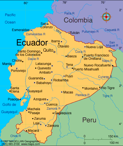
Map of Ecuador
President:
Rafael Correa (2007)
Land area: 106,888 sq
mi (276,840 sq km); total area: 109, 483 sq mi (283,560 sq
km)
Population (2014 est.): 15,654,411 (growth rate: 1.37%); birth rate: 18.87/1000; infant mortality rate:
17.93/1000; life expectancy: 76.36
Capital (2011 est.):
Quito 1.622
Largest cities: Guayaquil,
2.287 million (2011)
Monetary unit: U.S.
dollar
National name: República del
Ecuador
Languages:
Spanish (Castillian) 93% (official), Quechua 4.1%, other indigenous 0.7%, foreign 2.2%
note: (Quechua and Shuar are official languages of
intercultural relations; other indigenous languages are in official use
by indigenous peoples in the areas they inhabit) (2010 est.)
Ethnicity/race:
mestizo (mixed Amerindian and white) 71.9%, Montubio
7.4%, Afroecuadorian 7.2%, Amerindian 7%, white 6.1%, other 0.4% (2010
census)
National Holiday:
Independence Day, August 10
Religion:
Roman Catholic 95%, other 5%
Literacy rate: 91.6% (2011 est.)
Economic summary: GDP/PPP (2011 est.):
$157.6 billion; per capita $10,600. Real growth rate: 45%.
Inflation: 2.6%. Unemployment: 4.2%
Arable land: 4.51%. Agriculture: bananas, coffee, cocoa,
rice, potatoes, manioc (tapioca), plantains, sugarcane; cattle, sheep,
pigs, beef, pork, dairy products; balsa wood; fish, shrimp. Labor
force: 6.953 million (2012 est.); agriculture 27.8%, industry
17.8%, services 54.4% (2012). Industries: petroleum, food
processing, textiles, wood products, chemicals. Natural
resources: petroleum, fish, timber, hydropower. Exports:
$25.48 billion (2013 est.): petroleum, bananas, cut flowers, shrimp.
Imports: $26.22 billion (2013 est.): vehicles, medicinal products,
telecommunications equipment, electricity. Major trading
partners: U.S., Peru, Japan, Russia, China, Colombia, Brazil, Chile, Panama
(2012).
Communications: Telephones:
main lines in use: 2.31 million (2012); mobile cellular: 16.457 million
(2012). Broadcast media:Ecuador has multiple
TV networks and many local channels, as well as more than 300 radio
stations; many TV and radio stations are privately owned; the government
owns or controls 5 national TV stations and multiple radio stations;
broadcast media required by law to give the government free air time to
broadcast programs produced by the state (2007). Internet hosts:
170,538 (2012). Internet users: 3.352 million (2009).
Transportation: Railways: total: 965 km
(2008). Roadways: total: 43,670 km; paved: 6,472 km; unpaved:
37,198 km (2011). Waterways: 1,500 km (most inaccessible)
(2012). Ports and harbors: Esmeraldas, Guayaquil, La Libertad,
Manta, Puerto Bolivar. Airports: 432 (2013).
International disputes:
organized illegal narcotics operations in Colombia penetrate across
Ecuador's shared border, which thousands of Colombians also cross to
escape the violence in their home country.
-------------------- o --------------------
No comments:
Post a Comment