EGYPT
Geography: Egypt, at the northeast corner of Africa on the Mediterranean Sea, is bordered on the west by Libya, on the south by the Sudan, and on the east by the Red Sea and Israel. It is nearly one and one-half times the size of Texas. Egypt is divided into two unequal, extremely arid regions by the landscape's dominant feature, the northward-flowing Nile River. The Nile starts 100 mi (161 km) south of the Mediterranean and fans out to a sea front of 155 mi between the cities of Alexandria and Port Said.
Government: Republic.
History: Egyptian history dates back to about 4000 B.C. , when the kingdoms of upper and lower Egypt, already highly sophisticated, were united. Egypt's golden age coincided with the 18th and 19th dynasties (16th to 13th century B.C. ), during which the empire was established. Persia conquered Egypt in 525 B.C. , Alexander the Great subdued it in 332 B.C. , and then the dynasty of the Ptolemies ruled the land until 30 B.C. , when Cleopatra, last of the line, committed suicide and Egypt became a Roman, then Byzantine, province. Arab caliphs ruled Egypt from 641 until 1517, when the Turks took it for their Ottoman Empire.
Napoléon's armies occupied the country from 1798 to 1801. In 1805, Mohammed Ali, leader of a band of Albanian soldiers, became pasha of Egypt. After completion of the Suez Canal in 1869, the French and British took increasing interest in Egypt. British troops occupied Egypt in 1882, and British resident agents became its actual administrators, though it remained under nominal Turkish sovereignty. In 1914, this fiction was ended, and Egypt became a protectorate of Britain.
Egyptian nationalism, led by Zaghlul Pasha and the Wafd Party, forced Britain to relinquish its claims on the country. Egypt became an independent sovereign state on Feb. 28, 1922, with Fu'ad I as its king. In 1936, by an Anglo-Egyptian treaty of alliance, all British troops and officials were to be withdrawn, except from the Suez Canal Zone. When World War II started, Egypt remained neutral.
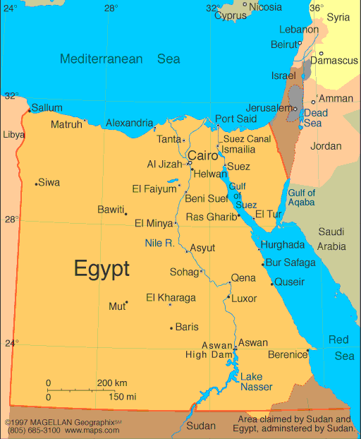
Map of Egypt
Chairman of the Supreme Council of the Armed Forces:
Field Marshal Mohammed Hussein Tantawi (2011)
President: Gen. Abdel Fattah el-Sisi (2014)
Prime
Minister: Ibrahim Mehlib (2014)
Land area:
384,344 sq mi (995,451 sq km); total area: 386,662 sq mi
(1,001,450 sq km)
Population (2014 est.): 86,895,099 (growth rate: 1.84%); birth rate: 23.35/1000;
infant mortality rate: 22.41/1000; life expectancy: 73.45
Capital and largest city (2011 est.):
Cairo, 11.169 million
Other large cities:
Alexandria, 4.494 million (2011)
Monetary unit: Egyptian
pound
National name: Jumhuriyat
Misr al-Arabiyah
Languages:
Arabic (official), English and French widely
understood by educated classes
Ethnicity/race:
Egyptian 99.6%, other 0.4% (2006 census)
National Holiday:
Revolution Day, July 23
Religions:
Muslim (predominantly Sunni) 90%, Christian (majority
Coptic Orthodox, other Christians include Armenian Apostolic, Catholic,
Maronite, Orthodox, and Anglican) 10% (2012 est.)
Literacy rate: 73.9%
(2012 est.)
Economic summary:
GDP/PPP $551.4 billion (2013 est.); per capita $6,600. Real
growth rate: 1.8%. Inflation: 9%. Unemployment:
13.4%. Arable land: 2.87%. Agriculture: cotton, rice, corn,
wheat, beans, fruits, vegetables; cattle, water buffalo, sheep, goats.
Labor force: 27.69 million (2013); agriculture 29%, industry
24%, services 47% (2011 est.). Industries: textiles, food
processing, tourism, chemicals, pharmaceuticals, hydrocarbons,
construction, cement, metals, light manufactures. Natural
resources: petroleum, natural gas, iron ore, phosphates,
manganese, limestone, gypsum, talc, asbestos, lead, zinc.
Exports: $24.81 billion (2013 est.): crude oil and
petroleum products, cotton, textiles, metal products, chemicals.
Imports: $59.22 billion (2013 est.): machinery and
equipment, foodstuffs, chemicals, wood products, fuels. Major
trading partners: Italy, U.S., Germany,
China, UK, Saudi Arabia, India, Turkey, Libya, Ukraine, Russia (2012).
Communications: Telephones: main lines in
use: 8.557 million (2012); mobile cellular: 96.8 million (2012).
Broadcast media: mix of state-run and private
broadcast media; state-run TV operates 2 national and 6 regional
terrestrial networks as well as a few satellite channels; about 20
private satellite channels and a large number of Arabic satellite
channels are available via subscription; state-run radio operates about
70 stations belonging to 8 networks; 2 privately owned radio stations
operational (2008). Internet hosts: 200,430 (2012). Internet
users: 20.136 million (2009).
Transportation: Railways: total: 5,083 km
(2009). Roadways: total: 137,430 km; (2010 est.). Waterways: 3,500 km; note: includes Nile
River, Lake Nasser, Alexandria-Cairo Waterway, and numerous smaller
canals in delta; Suez Canal (193.5 km including approaches) navigable
by oceangoing vessels drawing up to 17.68 m (2011). Ports and
harbors: Alexandria, Damietta, El Dekheila, Port Said, Suez, Zeit.
Airports: 83 (2013).
International
disputes: Sudan claims but Egypt de facto administers
security and economic development of Halaib region north of the 22nd
parallel boundary; Egypt no longer shows its administration of the Bir
Tawil trapezoid in Sudan on its maps; Gazan breaches in the security
wall with Egypt in January 2008 highlight difficulties in monitoring the
Sinai border; Saudi Arabia claims Egyptian-administered islands of
Tiran and Sanafir.
-------------------- o --------------------
No comments:
Post a Comment