EL SALVADOR
Geography: Situated on the Pacific coast of Central America, El Salvador has Guatemala to the west and Honduras to the north and east. It is the smallest of the Central American countries, with an area equal to that of Massachusetts, and it is the only one without an Atlantic coastline. Most of the country is on a fertile volcanic plateau about 2,000 ft (607 m) high.
Government: Republic.
History: The Pipil Indians, descendants of the Aztecs, likely migrated to the region in the 11th century. In 1525, Pedro de Alvarado, a lieutenant of Cortés's, conquered El Salvador.
El Salvador, with the other countries of Central America, declared its independence from Spain on Sept. 15, 1821, and was part of a federation of Central American states until that union dissolved in 1838. For decades after its independence, El Salvador experienced numerous revolutions and wars against other Central American republics. From 1931 to 1979 El Salvador was ruled by a series of military dictatorships.
In 1969, El Salvador invaded Honduras after Honduran landowners deported several thousand Salvadorans. The four-day war became known as the “football war” because it broke out during a soccer game between the two countries.
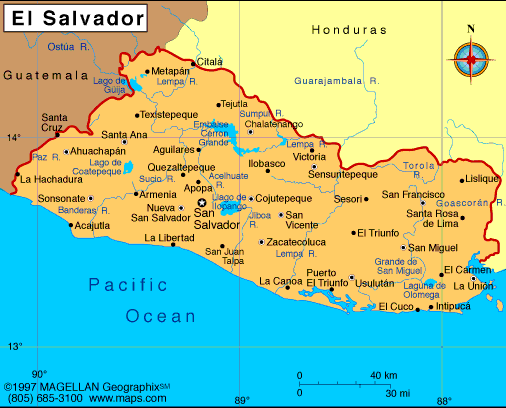
Map of El
Salvador
President: Salvador Sánchez Cerén (2014)
Land area: 8,000 sq mi (20,720 sq km);
total area: 8,124 sq mi (21,040 sq km)
Population (2014 est.): 6,125,512 (growth
rate: 0.27%); birth rate: 16.79/1000; infant mortality rate: 18.44/1000;
life expectancy: 74.18
Capital and largest city (2011 est.):
San Salvador, 1.605 million
Other large cities:
Santa Ana, 167,200; San Miguel, 145,100; Zacatecoluca, 36,700
Monetary units: Colón; U.S. dollar
National
name: República de El Salvador
Languages:
Spanish, Nahua (among some Amerindians)
Ethnicity/race:
mestizo 86.3%, white 12.7%, Amerindian 1% (2007 census)
National Holiday:
Independence Day, September 15
Religions:
Roman Catholic 57.1%, Protestant 21.2%, Jehovah's Witnesses 1.9%, Mormon 0.7%, other religions 2.3%, none 16.8% (2003 est.)
Literacy rate:
84.5% (2010 est.)
Economic summary:
GDP/PPP (2013 est.): $47.47 billion; per capita $7,500. Real
growth rate: 1.6%. Inflation: 0.9%. Unemployment:
6.3%. Arable land:
31.61%. Agriculture: coffee, sugar, corn, rice, beans, oilseed,
cotton, sorghum; beef, dairy products; shrimp. Labor force:
2.738 million; agriculture 21%, industry 10%, services 58% (2007
est.). Industries: food processing, beverages, petroleum,
chemicals, fertilizer, textiles, furniture, light metals. Natural
resources: hydropower, geothermal power, petroleum, arable
land. Exports: $5.112 billion (2013 est.): offshore assembly
exports, coffee, sugar, shrimp, textiles, chemicals, electricity.
Imports: $10.03 billion (2013 est.): raw materials, consumer
goods, capital goods, fuels, foodstuffs, petroleum, electricity.
Major trading partners: U.S., Guatemala, Honduras, Nicaragua,
Mexico, Germany, China (2012).
Communications: Telephones: main lines in
use: 1.06 million (2012); mobile cellular: 8.65 million (2012).
Broadcast media: multiple privately owned
national terrestrial TV networks, supplemented by cable TV networks that
carry international channels; hundreds of commercial radio broadcast
stations and 1 government-owned radio broadcast station (2007). Internet
hosts: 24,070 (2012). Internet users: 746,000 (2009).
Transportation: Railways: total: 283 km;
note: railways not in operation since 2005 because of disuse and lack
of maintenance due to high costs (2008). Roadways: total:
6,918 km; paved: 3,247 km (including 341 km of expressways); unpaved:
3,671 km (2010 est.). Waterways: Rio Lempa partially navigable
(2011). Ports and harbors: Acajutla, Puerto Cutuco.
Airports: 68 (2013).
International
disputes: in 1992, the ICJ ruled on the delimitation of "bolsones"
(disputed areas) along the El Salvador-Honduras boundary, but despite
OAS intervention and a further ICJ ruling in 2003, full demarcation of
the border remains stalled; the 1992 ICJ ruling advised a tripartite
resolution to a maritime boundary in the Gulf of Fonseca advocating
Honduran access to the Pacific; El Salvador continues to claim tiny
Conejo Island, not identified in the ICJ decision, off Honduras in the
Gulf of Fonseca.
-------------------- o --------------------
No comments:
Post a Comment