EQUATORIAL GUINEA
Geography: Equatorial Guinea, formerly Spanish Guinea, consists of Río Muni (10,045 sq mi; 26,117 sq km), on the western coast of Africa, and several islands in the Gulf of Guinea, the largest of which is Bioko (formerly Fernando Po) (785 sq mi; 2,033 sq km). The other islands are Annobón, Corisco, Elobey Grande, and Elobey Chico. The total area is twice that of Connecticut.
Government: Dictatorship.
History: The mainland was originally inhabited by Pygmies. The Fang and Bubi migrated there in the 17th century and to the main island of Fernando Po (now called Bioko) in the 19th century. In the 18th century, the Portuguese ceded land to the Spanish that included Equatorial Guinea. From 1827 to 1844, Britain administered Fernando Po, but it was then reclaimed by Spain. Río Muni, the mainland, was not occupied by the Spanish until 1926. Spanish Guinea, as it was then called, gained independence from Spain on Oct. 12, 1968. It is Africa's only Spanish-speaking country.
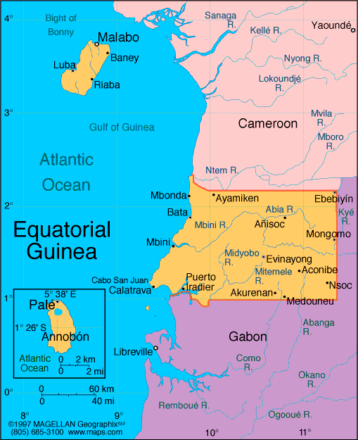
Map of
Equatorial Guinea
President: Col. Teodoro
Obiang Nguema Mbasogo (1979)
Prime
Minister: Vicente Ehate Tomi (2012)
Total area: 10,830 sq mi (28,050 sq
km)
Population (2014 est.):
722,254 (growth rate: 2.54%); birth rate: 33.83/1000; infant mortality rate:
71.12/1000; life expectancy: 63.49
Capital and largest city (2011 est.):
Malabo, 137,000
Monetary unit: CFA Franc
National name: Républica de Guinea
Ecuatorial
Languages:
Spanish (official) 67.6%, other (includes French (official), Fang, Bubi) 32.4% (1994 census)
Ethnicity/race:
Fang 85.7%, Bubi 6.5%, Mdowe 3.6%, Annobon 1.6%, Bujeba 1.1%, other 1.4% (1994 census)
National Holiday:
Independence Day, October 12
Religions:
nominally Christian and predominantly Roman
Catholic, pagan practices
Literacy
rate: 94.2% (2011 est.)
Economic
summary: GDP/PPP (2013 est.): $19.68 billion; per capita
$25,700 (2011 est.). Real growth rate: –1.5%. Inflation: 6%. Unemployment: 22.3% (2009 est.). Arable land: 4.63%.
Agriculture: coffee, cocoa, rice, yams, cassava (tapioca),
bananas, palm oil nuts; livestock; timber. Labor force: 195,200 (2007).
Industries: petroleum, fishing, sawmilling, natural gas.
Natural resources: petroleum, natural gas, timber, gold,
bauxite, diamonds, tantalum, sand and gravel, clay. Exports:
$15.44 billion (2013 est.): petroleum, methanol, timber, cocoa.
Imports: $7.943 billion (2013 est.): petroleum sector
equipment, other equipment. Major trading partners: U.S.,
China, Spain, France, Netherlands, Côte
d'Ivoire, Italy, Brazil (2012).
Communications:
Telephones: main lines in use: 14,900 (2012); mobile cellular:
501,000 (2012). Broadcast media: state
maintains control of broadcast media with domestic broadcast media
limited to 1 state-owned TV station, 1 private TV station owned by the
president's eldest son, 1 state-owned radio station, and 1 private radio
station owned by the president's eldest son; satellite TV service is
available; transmissions of multiple international broadcasters are
accessible (2013). Internet
hosts: 7 (2012). Internet users: 14,400 (2009).
Transportation: Railways: total: 0 km.
Highways: total: 2,880 km (2000 est.). Ports and
harbors: Bata, Luba, Malabo. Airports: 7 (2013).
International disputes: in 2002, ICJ ruled on
an equidistance settlement of Cameroon-Equatorial Guinea-Nigeria
maritime boundary in the Gulf of Guinea, but a dispute between
Equatorial Guinea and Cameroon over an island at the mouth of the Ntem
River, imprecisely defined maritime coordinates in the ICJ decision,
and the unresolved Bakasi allocation contribute to the delay in
implementation; UN has been pressing Equatorial Guinea and Gabon to
pledge to resolve the sovereignty dispute over Gabon-occupied Mbane
Island and create a maritime boundary in the hydrocarbon-rich Corisco
Bay.
-------------------- o --------------------
No comments:
Post a Comment