ETHIOPIA
Geography: Ethiopia is in east-central Africa, bordered on the west by the Sudan, the east by Somalia and Djibouti, the south by Kenya, and the northeast by Eritrea. It has several high mountains, the highest of which is Ras Dashan at 15,158 ft (4,620 m). The Blue Nile, or Abbai, rises in the northwest and flows in a great semicircle before entering the Sudan. Its chief reservoir, Lake Tana, lies in the northwest.
Government: Federal republic.
History: Archeologists have found the oldest known human ancestors in Ethiopia, including Ardipithecus ramidus kadabba (c. 5.8–5.2 million years old) and Australopithecus anamensis (c. 4.2 million years old). Originally called Abyssinia, Ethiopia is sub-Saharan Africa's oldest state, and its Solomonic dynasty claims descent from King Menelik I, traditionally believed to have been the son of the queen of Sheba and King Solomon. The current nation is a consolidation of smaller kingdoms that owed feudal allegiance to the Ethiopian emperor.
Hamitic peoples migrated to Ethiopia from Asia Minor in prehistoric times. Semitic traders from Arabia penetrated the region in the 7th century B.C. Its Red Sea ports were important to the Roman and Byzantine Empires. Coptic Christianity was brought to the region in A.D. 341, and a variant of it became Ethiopia's state religion. Ancient Ethiopia reached its peak in the 5th century, then was isolated by the rise of Islam and weakened by feudal wars.
Modern Ethiopia emerged under Emperor Menelik II, who established its independence by routing an Italian invasion in 1896. He expanded Ethiopia by conquest. Disorders that followed Menelik's death brought his daughter to the throne in 1917, with his cousin, Tafari Makonnen, as regent and heir apparent. When the empress died in 1930, Tafari was crowned Emperor Haile Selassie I.
Haile Selassie, called the “Lion of Judah,” outlawed slavery and tried to centralize his scattered realm, in which 70 languages were spoken. In 1931, he created a constitution, revised in 1955, that called for a parliament with an appointed senate, an elected chamber of deputies, and a system of courts. But basic power remained with the emperor.
Fascist Italy invaded Ethiopia on Oct. 3, 1935, forcing Haile Selassie into exile in May 1936. Ethiopia was annexed to Eritrea, then an Italian colony, and to Italian Somaliland, forming Italian East Africa. In 1941, British troops routed the Italians, and Haile Selassie returned to Addis Ababa. In 1952, Eritrea was incorporated into Ethiopia.
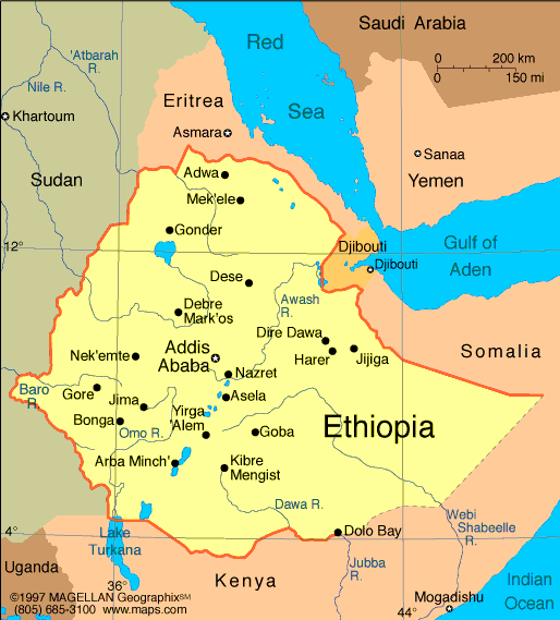
Map of Ethiopia
President: Mulatu Teshome Wirtu (2013)
Prime
Minister: Hailemariam Desalegn (2012)
Land area: 432,310 sq mi (1,119,683 sq
km); total area: 435,186 sq mi (1,127,127 sq km)
Population (2014 est.): 96,633,458 (growth
rate: 2.89%); birth rate: 37.66/1000; infant mortality rate: 55.77/1000;
life expectancy: 60.75
Capital and largest city (2011 est.):
Addis Ababa, 2.979
Monetary unit: Birr
National name: Ityop'iya Federalawi
Demokrasiyawi Ripeblik
Languages:
Oromo (official working language in the State of Oromiya)
33.8%, Amharic (official national language) 29.3%, Somali (official
working language of the State of Sumale) 6.2%, Tigrigna (Tigrinya)
(official working language of the State of Tigray) 5.9%, Sidamo 4%,
Wolaytta 2.2%, Gurage 2%, Afar (official working language of the State
of Afar) 1.7%, Hadiyya 1.7%, Gamo 1.5%, Gedeo 1.3%, Opuuo 1.2%, Kafa
1.1%, other 8.1%, English (major foreign language taught in schools),
Arabic (2007 est.)
Ethnicity/race:
Oromo 34.4%, Amhara (Amara) 27%, Somali (Somalie) 6.2%,
Tigray (Tigrinya) 6.1%, Sidama 4%, Gurage 2.5%, Welaita 2.3%, Hadiya
1.7%, Afar (Affar) 1.7%, Gamo 1.5%, Gedeo 1.3%, Silte 1.3%, Kefficho
1.2%, other 10.5% (2007 est.)
National Holiday:
Independence Day, May 28
Religions:
Ethiopian Orthodox 43.5%, Muslim 33.9%, Protestant 18.5%, traditional 2.7%, Catholic 0.7%, other 0.6% (2007 est.)
Literacy rate: 39% (2007 est.)
Economic summary: GDP/PPP (2013 est.):
$118.2 billion; per capita $1,300. Real growth rate: 7%.
Inflation: 8.4%. Unemployment: 17.5% (2012). Arable land:
13.19%. Agriculture: cereals, pulses, coffee, oilseed, cotton,
sugarcane, potatoes, qat, cut flowers; hides, cattle, sheep, goats;
fish. Labor force: 45.65 million (2013); agriculture and animal
husbandry 85%, government and services 10%, industry and construction
5% (2009). Industries: food processing, beverages, textiles,
leather, chemicals, metals processing, cement. Natural
resources: small reserves of gold, platinum, copper, potash,
natural gas, hydropower. Exports: $3.214 billion (2013
est.): coffee, qat, gold, leather products, live animals, oilseeds.
Imports: $10.68 billion (2013 est.): food and live
animals, petroleum and petroleum products, chemicals, machinery, motor
vehicles, cereals, textiles. Major trading partners: Belgium,
Germany, Saudi Arabia, U.S., India, China
(2012).
Communications: Telephones:
main lines in use: 797,500 (2012); mobile cellular: 20.524 (2012).
Broadcast media: 1 public TV station
broadcasting nationally and 1 public radio broadcaster with stations in
each of the 13 administrative districts; a few commercial radio stations
and roughly a dozen community radio stations (2009).
Internet hosts: 179 (2012). Internet users: 447,300
(2009).
Transportation: Railways:
total: 681 km (railway is under joint control of Djibouti and Ethiopia but is largely inoperable (2008)). Highways: total: 44,359 km ; paved: 6,064 km; unpaved:
38,295 km (2011). Ports and harbors: Ethiopia is landlocked and uses the ports of Djibouti in Djibouti and Berbera in Somalia.
Airports: 57 (2013)
International
disputes: Eritrea and Ethiopia agreed to abide by the 2002
Eritrea-Ethiopia Boundary Commission's (EEBC) delimitation decision, but
neither party responded to the revised line detailed in the November
2006 EEBC Demarcation Statement; the undemarcated former British
administrative line has little meaning as a political separation to
rival clans within Ethiopia's Ogaden and southern Somalia's Oromo
region; Ethiopian forces invaded southern Somalia and routed Islamist
Courts from Mogadishu in January 2007; "Somaliland" secessionists
provide port facilities in Berbera and trade ties to landlocked
Ethiopia; civil unrest in eastern Sudan has hampered efforts to
demarcate the porous boundary with Ethiopia.
-------------------- o --------------------
No comments:
Post a Comment