GABON
Geography: This West African country with the Atlantic as its western border is also bounded by Equatorial Guinea, Cameroon, and the Congo. Its area is slightly less than Colorado's. Most of the country is covered by a dense tropical forest.
Government: Republic.
History: The earliest humans in Gabon were believed to be the Babinga, or Pygmies, dating back to 7000 B.C. , who were later followed by Bantu groups from southern and eastern Africa. Now there are many tribal groups in the country, the largest being the Fang peoples, who constitute 25% of the population.
Gabon was first explored by the Portuguese navigator Diego Cam in the 15th century. In 1472, the Portuguese explorers encountered the mouth of the Como River and named it “Rio de Gabao,” river of Gabon, which later became the name of the country. The Dutch began arriving in 1593, and the French in 1630. In 1839, the French founded their first settlement on the left bank of the Gabon estuary and gradually occupied the hinterland during the second half of the 19th century. The land became a French territory in 1888, an autonomous republic within the French Union after World War II, and an independent republic on Aug. 17, 1960.
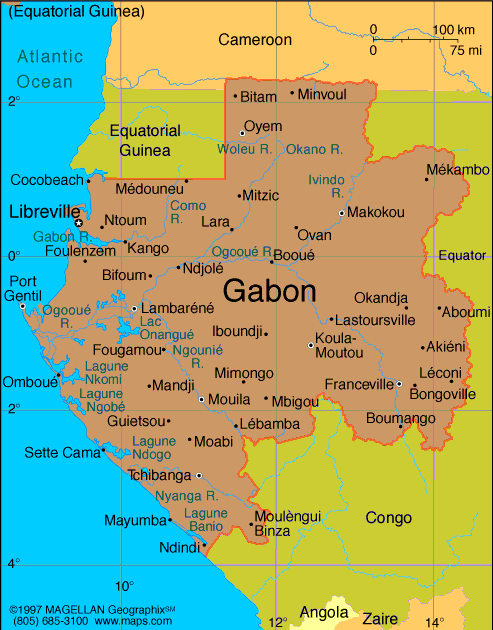
Map of Gabon
President: Ali Bongo Ondimba
(2009)
Prime Minister: Daniel Ona Ondo
(2014)
Land area: 99,486 sq mi (257,669 sq km);
total area: 103,346 sq mi (267,667 sq km)
Population (2014 est.): 1,672,597 (growth
rate: 1.94%); birth rate: 34.64/1000; infant mortality rate: 47.03/1000;
life expectancy: 52.06
Capital and largest city (2014 est.):
Libreville, 695,000
Monetary
unit: CFA Franc
National
name: République Gabonaise
Languages:
French (official), Fang, Myene, Nzebi,
Bapounou/Eschira, Bandjabi
Ethnicity/race:
Bantu tribes, including four major tribal groupings
(Fang, Bapounou, Nzebi, Obamba); other Africans and Europeans, 154,000,
including 10,700 French and 11,000 persons of dual nationality
Religions:
Christian 55%-75%, animist, Muslim less than 1%
National Holiday:
Independence Day, August 17
Literacy rate: 82.3% (2012 est.)
Economic summary: GDP/PPP (2014 est.):
$34.28 billion; per capita $21,600. Real growth rate: 5.1%.
Inflation: 7% (2014). Unemployment: 21% (2006 est.). Arable
land: 1.27%. Agriculture: cocoa, coffee, sugar, palm oil,
rubber; cattle; okoume (a tropical softwood); fish. Labor
force: 636,000 (2014); agriculture 60%, industry 15%, services
25%. Industries: petroleum extraction and refining; manganese,
gold; chemicals, ship repair, food and beverages, textiles, lumbering
and plywood, cement. Natural resources: petroleum, natural gas,
diamond, niobium, manganese, uranium, gold, timber, iron ore,
hydropower. Exports: $8.4016 billion (2014 est.): crude
oil, timber, manganese, uranium. Imports: $4.76
billion (2014 est.): machinery and equipment, foodstuffs,
chemicals, construction materials. Major trading partners:
U.S., China, France, Trinidad and Tobago, Netherlands, Belgium,
Spain, Australia, China, India, Japan, Côte d'Ivoire (2013).
Member of French Community
Communications: Telephones: main
lines in use: 17,000 (2012); mobile cellular: 2.93 million (2012). Broadcast media:
state owns and operates 2 TV stations and 2 radio broadcast stations; a
few private radio and TV stations; transmissions of at least 2
international broadcasters are accessible; satellite service
subscriptions are available (2007). Internet hosts: 127 (2012). Internet users: 98,800 (2009).
Transportation:
Railways: total: 649 km (2009). Highways: total:
9,170 km; paved: 1,097 km; unpaved: 8,073 km (2007 est.). Waterways:
1,600 km (310 km on Ogooue River) (2010). Ports and
harbors: Gamba, Libreville, Lucina, Owendo, Port-Gentil.
Airports: 44 (2013).
International
disputes: UN presses Equatorial Guinea and Gabon to resolve the
sovereignty dispute over Gabon-occupied Mbane Island and to establish
a maritime boundary in hydrocarbon-rich Corisco Bay.
-------------------- o --------------------
No comments:
Post a Comment