GAMBIA
Geography: Situated on the Atlantic coast in westernmost Africa and surrounded on three sides by Senegal, Gambia is twice the size of Delaware. The Gambia River flows for 200 mi (322 km) through Gambia on its way to the Atlantic. The country, the smallest on the continent, averages only 20 mi (32 km) in width.
Government: Republic.
History: Since the 13th century, the Wolof, Malinke, and Fulani peoples have settled in what is now Gambia. The Portuguese were the first European explorers, encountering the Gambia River in 1455, and in 1681, the French founded an enclave at Albredabut. During the 17th century, Gambia was settled by various companies of English merchants. Slavery was the chief source of revenue before it was abolished in 1807. Gambia became a British Crown colony in 1843 and an independent nation within the Commonwealth of Nations on Feb. 18, 1965. Full independence was approved in a 1970 referendum, and on April 24 of that year Gambia proclaimed itself a republic.
Dauda Kairaba Jawara served as Gambia's president from 1970 to 1994. A military coup led by Capt. Yahya Jammeh deposed the president in July 1994, suspended the constitution, and banned existing political parties. Jammeh promised new elections, which were held in Sept. 1996 and which he won with 55% of the vote. In 1997, he returned the country to civilian rule, and in 2001, he lifted the ban against opposition parties. Censorship of the press and other repressive measures mar the country's transition to democracy. In Dec. 2004, Gambia passed a media law that allows the state to jail journalists found guilty of libel and sedition. In September presidential elections, incumbent Yahya Jammeh won a third term.
In Nov. 2011 presidential elections, incumbent Yahya Jammeh won 72% of the vote, Ousainou Darboe 17%, and Hamat Bah 11% with 83% voter turnout.
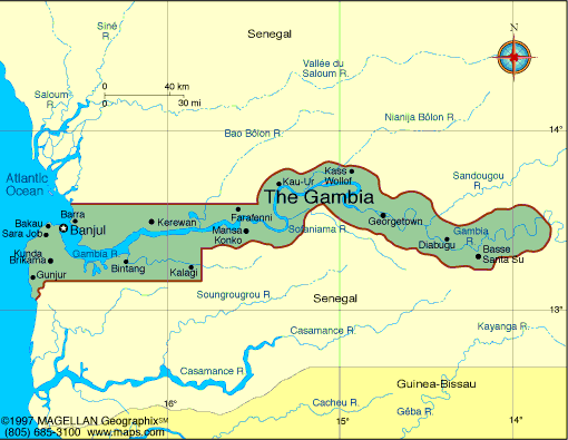
Map of Gambia
President:
Yahya Jammeh (1994)
Land area: 3,861 sq mi (10,000 sq km);
total area: 4,363 sq mi (11,300 sq km)
Population (2014 est.): 1,925,527 (growth
rate: 2.23%); birth rate 31.75/1000; infant mortality rate: 65.74/1000;
life expectancy: 64.36
Capital (2014 est.):
Banjul, 489,000
Monetary unit: Dalasi
Languages:
English (official), Mandinka, Wolof, Fula, other
indigenous vernaculars
Ethnicity/race:
African 99% (Mandinka 42%, Fula 18%, Wolof 16%,
Jola 10%, Serahuli 9%, other 4%), non-African 1%
Religions:
Islam 90%, Christian 8%, indigenous 2%
National Holiday:
Independence Day, February 18
Literacy rate: 52% (2012 est.)
Economic summary: GDP/PPP $3.362 billion (2014 est.); per capita: $1,700 (2014 est.). Real growth rate: 7.4%.
Inflation: 5.6%. Unemployment: n.a. Arable land:
43.48%. Agriculture: rice, millet, sorghum, peanuts, corn, sesame,
cassava (tapioca), palm kernels; cattle, sheep, goats. Labor force: 777,100 (2007) agriculture 75%, industry, commerce, and services
19%, government 6%. Industries: processing peanuts, fish, and
hides; tourism, beverages, agricultural machinery assembly,
woodworking, metalworking, clothing. Natural resources: fish,
titanium (rutile and ilmenite), tin, zircon, silica sand, clay,
petroleum. Exports: $107.4 million (2014 est.): peanut
products, fish, cotton lint, palm kernels, reexports. Imports:
$353.1 million (2014 est.): foodstuffs, manufactures, fuel,
machinery and transport equipment. Major trading partners:
India, China, Senegal, Brazil,
(2013).
Member of Commonwealth of Nations
Communications: Telephones: main
lines in use: 64,200 (2012); mobile cellular: 1.526 million (2012). Broadcast media: state-owned,
single-channel TV service; state-owned radio station and 4
privately-owned radio stations; transmissions of multiple international
broadcasters are available, some via shortwave radio; foreign cable and
satellite TV subscription services are obtainable in some parts of the
country (2007). Internet
hosts: 656 (2012). Internet users: 130,100 (2009).
Transportation: Railways: 0 km.
Highways: total: 3,742 km; paved: 723 km; unpaved: 3,019 km
(2004). Waterways: 390 km (on River Gambia; small ocean-going
vessels can reach 190 km) (2010). Ports and harbors: Banjul.
Airports: 1 (2013).
International
disputes: attempts to stem refugees, cross-border raids, arms
smuggling, and other illegal activities by separatists from southern
Senegal's Casamance region as well as from conflicts in other west
African states.
-------------------- o --------------------
No comments:
Post a Comment