GERMANY
Geography: Located in central Europe, Germany is made up of the North German Plain, the Central German Uplands (Mittelgebirge), and the Southern German Highlands. The Bavarian plateau in the southwest averages 1,600 ft (488 m) above sea level, but it reaches 9,721 ft (2,962 m) in the Zugspitze Mountains, the highest point in the country. Germany's major rivers are the Danube, the Elbe, the Oder, the Weser, and the Rhine. Germany is about the size of Montana.
Government: Federal republic.
History: The Celts are believed to have been the first inhabitants of Germany. They were followed by German tribes at the end of the 2nd century B.C. German invasions destroyed the declining Roman Empire in the 4th and 5th centuries A.D. One of the tribes, the Franks, attained supremacy in western Europe under Charlemagne, who was crowned Holy Roman Emperor in 800. By the Treaty of Verdun (843), Charlemagne's lands east of the Rhine were ceded to the German Prince Louis. Additional territory acquired by the Treaty of Mersen (870) gave Germany approximately the area it maintained throughout the Middle Ages. For several centuries after Otto the Great was crowned king in 936, German rulers were also usually heads of the Holy Roman Empire.
By the 14th century, the Holy Roman Empire was little more than a loose federation of the German princes who elected the Holy Roman Emperor. In 1438, Albert of Hapsburg became emperor, and for the next several centuries the Hapsburg line ruled the Holy Roman Empire until its decline in 1806. Relations between state and church were changed by the Reformation, which began with Martin Luther's 95 theses, and came to a head in 1547, when Charles V scattered the forces of the Protestant League at Mühlberg. The Counter-Reformation followed. A dispute over the succession to the Bohemian throne brought on the Thirty Years' War (1618–1648), which devastated Germany and left the empire divided into hundreds of small principalities virtually independent of the emperor.
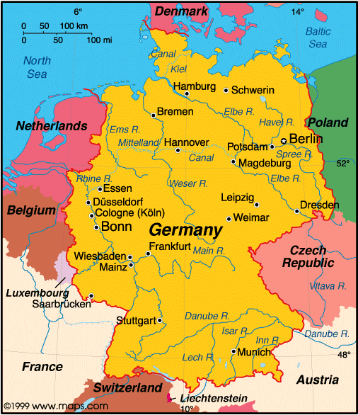
Map of Germany
President: Joachim Gauck (2012)
Chancellor: Angela Merkel (2005)
Land area: 135,236 sq mi (350,261 sq km); total
area: 137,846 sq mi (357,021 sq km)
Population (2014 est.): 80,996,685 (growth
rate: –0.18%); birth rate: 8.42/1000; infant mortality rate: 3.46/1000;
life expectancy: 80.44
Capital and largest city (2011 est.):
Berlin (capital since Oct. 3, 1990), 3.462
Other large cities: Hamburg, 1.796 million;
Munich, 1.364; Cologne, 1.006 million
Monetary unit: Euro (formerly Deutsche
mark)
National name:
Bundesrepublik Deutschland
Language:
German
Ethnicity/race:
German 91.5%, Turkish 2.4%, Italian 0.7%, Greek
0.4%, Polish 0.4%, other 4.6%
Religions:
Protestant 34%, Roman Catholic 34%, Islam 4%,
Unaffiliated or other 28%
National Holiday:
Unity Day, October 3
Literacy rate: 99% (2003 est.)
Economic summary GDP/PPP (2013 est.):
$3.227 trillion; per capita $39,500. Real growth rate: 0.5%.
Inflation: 1.6%. Unemployment: 6%. Arable land:
33.25%. Agriculture: potatoes, wheat, barley, sugar beets,
fruit, cabbages; cattle, pigs, poultry. Labor force: 44.2
million; industry 24.6%, agriculture 1.6%, services 73.8% (2011).
Industries: among the world's largest and most technologically
advanced producers of iron, steel, coal, cement, chemicals, machinery,
vehicles, machine tools, electronics, food and beverages,
shipbuilding, textiles. Natural resources: iron ore, coal,
potash, timber, lignite, uranium, copper, natural gas, salt, nickel,
arable land. Exports: $1.493 trillion (2013 est.):
machinery, vehicles, chemicals, metals and manufactures, foodstuffs,
textiles. Imports: $1.233 trillion (2013 est.): machinery,
vehicles, chemicals, foodstuffs, textiles, metals. Major trading
partners: France, U.S., UK, Italy, Netherlands, Belgium, Austria,
Spain, China, Switzerland, Poland (2013).
Communications:
Telephones: main lines in use: 50.7 million (2012); mobile
cellular: 107.7 million (2012). Broadcast media: a
mixture of publicly-operated and privately-owned TV and radio stations;
national and regional public broadcasters compete with nearly 400
privately-owned national and regional TV stations; more than 90% of
households have cable or satellite TV; hundreds of radio stations
including multiple national radio networks, regional radio networks, and
a large number of local radio stations (2008) Internet hosts: 20.043 million
(2012). Internet users: 65.125 million (2009).
Transportation: Railways: total: 41,981 km
(2012). Highways: total: 644,480 km
(2012). Waterways: 7,467 km (2012); note: Rhine River carries
most goods; Main-Danube Canal links North Sea and Black Sea.
Ports and harbors: Bremen, Bremerhaven, Brunsbuttel, Duisburg,
Frankfurt, Hamburg, Karlsruhe, Mainz, Rostock, Wilhemshaven.
Airports: 539 (2013).
International
disputes: none.
-------------------- o --------------------
No comments:
Post a Comment