GUINEA-BISSAU
Geography: A neighbor of Senegal and Guinea in West Africa, on the Atlantic coast, Guinea-Bissau is about half the size of South Carolina. The country is a low-lying coastal region of swamps, rain forests, and mangrove-covered wetlands, with about 25 islands off the coast. The Bijagos archipelago extends 30 mi (48 km) out to sea.
Government: Republic.
History: The land now known as Guinea-Bissau was once the kingdom of Gabú, which was part of the larger Mali empire. After 1546 Gabú became more autonomous, and at least portions of the kingdom existed until 1867. The first European to encounter Guinea-Bissau was the Portuguese explorer Nuño Tristão in 1446; colonists in the Cape Verde islands obtained trading rights in the territory, and it became a center of the Portuguese slave trade. In 1879, the connection with the islands was broken.
The African Party for the Independence of Guinea-Bissau and Cape Verde (another Portuguese colony) was founded in 1956, and guerrilla warfare by nationalists grew increasingly effective. By 1974 the rebels controlled most of the countryside, where they formed a government that was soon recognized by scores of countries. The military coup in Portugal in April 1974 brightened the prospects for freedom, and in August the Lisbon government signed an agreement granting independence to the province. The new republic took the name Guinea-Bissau.
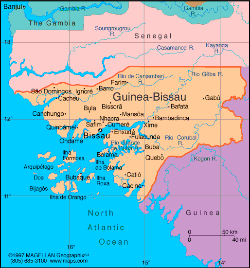
Map of
Guinea-Bissau
President:
José Mário Vaz (2014)
Prime
Minister: Domingos Simos Pereira (2014)
Land area: 10,811 sq mi (28,000 sq km);
total area: 13,946 sq mi (36,120 sq km)
Population (2014 est.): 1,693,398 (growth
rate: 1.93%); birth rate: 33.83/1000; infant mortality rate: 90.92/1000;
life expectancy: 49.87
Capital and largest city (2011 est.):
Bissau, 423,000
Monetary unit: CFA Franc
National name: Républica da
Guiné-Bissau
Languages:
Portuguese (official), Crioulo, African
languages
Ethnicity/race:
African 99% (Balanta 30%, Fula 20%, Manjaca 14%,
Mandinga 13%, Papel 7%), European and mulatto less than 1%
Religions:
Islam 50%, indigenous beliefs 40%, Christian 10%
National Holiday:
Independence Day, September 24
Literacy rate: 55.43% (2011 est.)
Economic summary: GDP/PPP (2013 est.):
$2.005 billion; per capita $1,200. Real growth rate: 3.5%.
Inflation: 1.9%. Unemployment: n.a. Arable land:
8.31%. Agriculture: rice, corn, beans, cassava (tapioca), cashew
nuts, peanuts, palm kernels, cotton; timber; fish. Labor force:
632,700 (2007); agriculture 82%, industry and services 18% (2000
est.). Industries: agricultural products processing, beer, soft
drinks. Natural resources: fish, timber, phosphates, bauxite,
clay, granite, limestone, unexploited deposits of petroleum.
Exports: $147.6 million (2013): fish, cashew nuts, shrimp,
peanuts, palm kernels, sawn lumber. Imports: $206.4 million (2013): foodstuffs, machinery and transport equipment,
petroleum products. Major trading partners: India, Portugal, Senegal, U.S., China, Togo, Nigeria (2012).
Communications: Telephones: main lines in
use: 5,000 (2012); mobile cellular: 1.1 million (2012). Broadcast
media: One state-owned TV station and a second station,
Radio e Televisao de Portugal (RTP) Africa, is operated by Portuguese
public broadcaster (RTP); 1 state-owned radio station, several private
radio stations, and some community radio stations; multiple
international broadcasters are available (2007). Internet
hosts: 90 (2012). Internet users: 37,100 (2009).
Transportation: Railways: 0 km.
Highways: total: 3,455 km; paved: 965 km; unpaved: 2,490 km
(2002). Waterways: rivers are navigable for some distance; many
inlets and creeks give shallow-water access to much of interior
(2009). Ports and harbors: Bissau, Buba, Cacheu, Farim.
Airports: 8 (2013).
International
disputes: in 2006, political instability within Senegal's
Casamance region resulted in thousands of Senegalese refugees,
cross-border raids, and arms smuggling into Guinea-Bissau.
-------------------- o --------------------
No comments:
Post a Comment