GUINEA

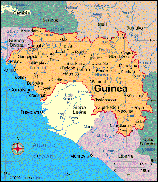
Geography: Guinea, in West Africa on the Atlantic, is also bordered by Guinea-Bissau, Senegal, Mali, Côte d'Ivoire, Liberia, and Sierra Leone. Slightly smaller than Oregon, the country consists of a coastal plain, a mountainous region, a savanna interior, and a forest area in the Guinea Highlands. The highest peak is Mount Nimba at 5,748 ft (1,752 m).
Government: Republic.
History: Beginning in 900, the Susu migrated from the north and began settling in the area that is now Guinea. The Susu civilization reached its height in the 13th century. Today the Susu make up about 20% of Guinea's population. From the 16th to the 19th century, the Fulani empire dominated the region. In 1849, the French claimed it as a protectorate. First called Rivières du Sud, the protectorate was rechristened French Guinea; finally, in 1895, it became part of French West Africa.
Guinea achieved independence on Oct. 2, 1958, and became an independent state with Sékou Touré as president. Under Touré, the country was the first avowedly Marxist state in Africa. Diplomatic relations with France were suspended in 1965, with the Soviet Union replacing France as the country's chief source of economic and technical assistance.

Map of Guinea
President: Alpha Condé (2010)
Prime Minister: Mohamed Said Fofana (2010)
Total area: 94,927 sq mi (245,861 sq
km)
Population (2013 est.): 11,176,026
(growth rate: 2.64%); birth rate: 36.3/1000; infant mortality rate:
57.11/1000; life expectancy: 59
Capital and largest city (2009 est.):
Conakry, 1.597 million
Monetary unit: Guinean franc
National
name: République de Guinée
Languages:
French (official), native tongues
(Malinké, Susu, Fulani)
Ethnicity/race:
Peuhl 40%, Malinke 30%, Soussou 20%, smaller ethnic groups 10%
Religions:
Islam 85%, Christian 8%, indigenous 7%
National Holiday:
Independence Day, October 2
Literacy rate: 41% (2010 est.)
Economic summary: GDP/PPP (2012 est.):
$12.37 billion; per capita $1,100. Real growth rate: 3.9%.
Inflation: 15.2%. Unemployment: n.a. Arable land:
11.59%. Agriculture: rice, coffee, pineapples, palm kernels,
cassava (tapioca), bananas, sweet potatoes; cattle, sheep, goats;
timber. Labor force: 4.7 million (2012); agriculture 76%,
industry and services 24% (2006 est.). Industries: bauxite,
gold, diamonds; alumina refining; light manufacturing and agricultural
processing industries. Natural resources: bauxite, iron ore,
diamonds, gold, uranium, hydropower, fish. Exports: $1.348 billion (2012 est.): bauxite, alumina, gold, diamonds, coffee,
fish, agricultural products. Imports: $2.606 billion (2012
est.): petroleum products, metals, machinery, transport equipment,
textiles, grain and other foodstuffs. Major trading partners:
India, Russia, Spain, France, US, Germany, Ireland,
Denmark, Ukraine, China, Netherlands (2012).
Communications: Telephones: main lines in
use: 18,000 (201); mobile cellular: 4.5 million (2011). Broadcast media:
government maintains marginal control over broadcast media; single
state-run TV station; state-run radio broadcast station also operates
several stations in rural areas; a steadily increasing number of
privately-owned radio stations, nearly all in Conakry, and about a dozen
community radio stations; foreign TV programming available via
satellite and cable subscription services (2011). Internet
hosts: 15 (2012). Internet users: 95,000 (2009).
Transportation: Railways: total: 1,185 km
(2008). Roadways: total: 44,348 km; paved: 4,342 km; unpaved:
40,006 km (2003). Waterways: 1,300 km (navigable by
shallow-draft native craft) (2011). Ports and harbors: Kamsar.
Airports: 16 (2012).
International
disputes: conflicts among rebel groups, warlords, and youth gangs
in neighboring states has spilled over into Guinea, resulting in
domestic instability; Sierra Leone pressures Guinea to remove its
forces from the town of Yenga occupied since 1998.
-------------------- o --------------------
No comments:
Post a Comment