GUYANA
Geography: Guyana is the size of Idaho and is situated on the northern coast of South America, east of Venezuela, west of Suriname, and north of Brazil. A tropical forest covers more than 80% of the country.
Government: Republic.
History: The Warrou people were the indigenous inhabitants of Guyana. The Dutch, English, and French established colonies in what is now known as Guyana, but by the early 17th century the majority of the settlements were Dutch. During the Napoleonic wars Britain took over the Dutch colonies of Berbice, Demerara, and Essequibo, which became British Guiana in 1831.
Slavery was outlawed in 1834, and the great need for plantation workers led to a large wave of immigration, primarily of East Indians. Today, about half of the population is of East Indian descent and about 36% are of African descent.
In 1889, Venezuela voiced its claim to a large swath of Guyanese territory, but ten years later an international tribunal ruled the land belonged to British Guiana.
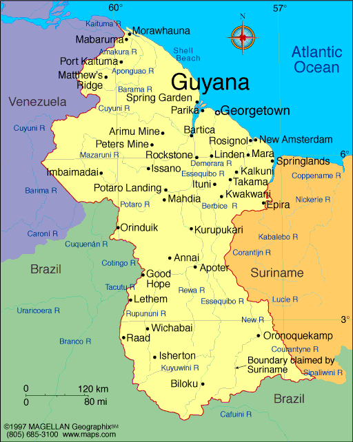
Map of Guyana
President: David Granger (2015)
Prime Minister: Samuel Hinds
(1992)
Land area: 76,004 sq mi (196,850 sq km);
total area: 83,000 sq mi (214,970 sq km)
Population (2014 est.): 735,554 (growth
rate: –0.11%); birth rate: 15.9/1000; infant mortality rate:
33.56/1000; life expectancy: 67.81
Capital and largest city (2011 est.):
Georgetown, 127,000
Monetary unit: Guyanese dollar
Languages:
English (official), Amerindian dialects,
Creole, Caribbean Hindustani (a dialect of Hindi), Urdu
Ethnicity/race:
East Indian 43.5%, black (African) 30.2%, mixed 16.7%, Amerindian 9.1%, other 0.5% (2002 census)
Religions:
Protestant 30.5% (Pentecostal 16.9%, Anglican 6.9%,
Seventh-Day Adventist 5%, Methodist 1.7%), Hindu 28.4%, Roman Catholic
8.1%, Jehovah's Witnesses 1.1%, Muslim 7.2%, other Christian 17.7%,
other 4.3%, none 4.3% (2002 census)
National Holiday:
Republic Day, February 23
Literacy rate: 91.8% (2002 est.)
Economic summary: GDP/PPP (2013
est.): $6.593 billion; per capita $8,500. Real growth rate: 5.3%. Inflation: 3.9%. Unemployment: 11% (2007). Arable land: 1.95%. Labor force: 313,100
(2009 est.); agriculture n.a., industry n.a., services n.a.
Agriculture: sugarcane, rice, wheat, vegetable oils; beef,
pork, poultry, dairy products; fish, shrimp. Industries:
bauxite, sugar, rice milling, timber, textiles, gold mining.
Natural resources: bauxite, gold, diamonds, hardwood timber,
shrimp, fish. Exports: $1.337 billion (2013 est.):
sugar, gold, bauxite/alumina, rice, shrimp, molasses, rum, timber.
Imports: $2.039 billion (2013 est.): manufactures,
machinery, petroleum, food. Major trading partners: Canada,
U.S., UK, Jamaica, Trinidad and
Tobago, Cuba, China, Suriname (2012).
Member of Commonwealth of Nations
Communications: Telephones: main lines
in use: 154,200 (2012); mobile cellular: 547,000 (2012). Broadcast media:
government-dominated broadcast media; the National Communications
Network (NCN) TV is state-owned; a few private TV stations relay
satellite services; the state owns and operates 2 radio stations
broadcasting on multiple frequencies capable of reaching the entire
country; government limits on licensing of new private radio stations
continue to constrain competition in broadcast media (2007).
Internet hosts: 24,936 (2012). Internet users: 189,600
(2009).
Transportation: Highways:
total: 7,970 km; paved: 590 km; unpaved: 7,380 km (2000 est.).
Waterways: 330 km (the Berbice, Demerara,
and Essequibo rivers are navigable by oceangoing vessels for 150 km, 100
km, and 80 km respectively) (2012) . Ports and terminals: Georgetown.
Airports: 117 (2013).
International disputes:
all of the area west of the Essequibo River is claimed by Venezuela
preventing any discussion of a maritime boundary; Guyana has expressed
its intention to join Barbados in asserting claims before UNCLOS that
Trinidad and Tobago's maritime boundary with Venezuela extends into
their waters; Suriname claims a triangle of land between the New and
Kutari/Koetari rivers in a historic dispute over the headwaters of the
Courantyne; Guyana seeks arbitration under provisions of the UN
Convention on the Law of the Sea (UNCLOS) to resolve the long-standing
dispute with Suriname over the axis of the territorial sea boundary in
potentially oil-rich waters.
-------------------- o --------------------
No comments:
Post a Comment