HONDURAS
Geography: Honduras, in the north-central part of Central America, has a Caribbean as well as a Pacific coastline. Guatemala is to the west, El Salvador to the south, and Nicaragua to the east. The second-largest country in Central America, Honduras is slightly larger than Tennessee. Generally mountainous, the country is marked by fertile plateaus, river valleys, and narrow coastal plains.
Government: Democratic constitutional republic.
History: During the first millennium, Honduras was inhabited by the Maya. Columbus explored the country in 1502. Honduras, with four other Central American nations, declared its independence from Spain in 1821 to form a federation of Central American states. In 1838, Honduras left the federation and became independent. Political unrest rocked Honduras in the early 1900s, resulting in an occupation by U.S. Marines. Dictator Gen. Tiburcio Carias Andino established a strong government in 1932.
In 1969, El Salvador invaded Honduras after Honduran landowners deported several thousand Salvadorans. Five thousand people ultimately died in what is called “the football war” because it broke out during a soccer game between the two countries. By threatening economic sanctions and military intervention, the Organization of American States (OAS) induced El Salvador to withdraw.
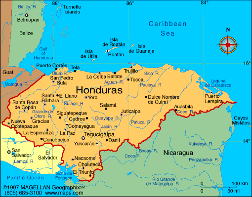
Map of Honduras
President: Juan Orlando Hernández (2014)
Land area: 43,201 sq mi (111,891 sq km);
total area: 43,278 sq mi (112,090 sq km)
Population (2014 est.): 8,598,561 (growth
rate: 1.74%); birth rate: 23.66/1000; infant mortality rate: 18.72/1000;
life expectancy: 70.91
Capital and largest city (2011 est.):
Tegucigalpa, 1.088 million
Monetary unit:
Lempira
National
name: República de Honduras
Languages:
Spanish (official), Amerindian dialects; English
widely spoken in business
Ethnicity/race:
mestizo 90%, Amerindian 7%, black 2%, white
1%
Religions:
Roman Catholic 97%, Protestant 3%
National Holiday:
Independence Day, September 15
Literacy rate: 85.1% (2011 est.)
Economic summary: GDP/PPP (2013 est.):
$39.23 billion; per capita $4,800. Real growth rate: 2.8%.
Inflation: 5.2%. Unemployment: 4.5%. Arable land:
9.07%. Agriculture: bananas, coffee, citrus; beef; timber;
shrimp. Labor force: 3.507 million (2013 est.); agriculture 39.2%, industry
20.9%, services 39.8%. Industries: sugar, coffee,
textiles, clothing, wood products. Natural resources: timber,
gold, silver, copper, lead, zinc, iron ore, antimony, coal, fish,
hydropower. Exports: $7.881 billion (2013 est.): apparel, coffee,
shrimp, automobile wire harnesses, cigars, bananas, gold, palm oil, fruit, lobster, lumber.
Imports: $11.34 billion (2013 est.): machinery and
transport equipment, industrial raw materials, chemical products,
fuels, foodstuffs. Major trading partners: U.S., Germany, Belgium, Nicaragua, Mexico, El Salvador, Guatemala, China, Costa Rica (2012).
Communications: Telephones: main lines in
use: 610,000 (2012); mobile cellular: 7.37 million (2012). Broadcast media:
multiple privately-owned terrestrial TV networks, supplemented by
multiple cable TV networks; Radio Honduras is the lone government-owned
radio network; roughly 300 privately-owned radio stations (2007).
Internet hosts: 30,955 (2012). Internet users: 731,700
(2009).
Transportation: Railways:
total: 44 km (2012). Roadways: total: 14,742 km; paved: 3,367
km; unpaved: 11,375 km (2012 est.). Waterways: 465 km (most
navigable only by small craft) (2012). Ports and harbors:
La Ceiba, Puerto Cortes, San Lorenzo, Tela. Airports:
103 (2013).
International disputes:
International Court of Justice (ICJ) ruled on the delimitation of
"bolsones" (disputed areas) along the El Salvador-Honduras border in
1992 with final settlement by the parties in 2006 after an Organization
of American States survey and a further ICJ ruling in 2003; the 1992 ICJ
ruling advised a tripartite resolution to a maritime boundary in the
Gulf of Fonseca with consideration of Honduran access to the Pacific; El
Salvador continues to claim tiny Conejo Island, not mentioned in the
ICJ ruling, off Honduras in the Gulf of Fonseca; Honduras claims the
Belizean-administered Sapodilla Cays off the coast of Belize in its
constitution, but agreed to a joint ecological park around the cays
should Guatemala consent to a maritime corridor in the Caribbean under
the OAS-sponsored 2002 Belize-Guatemala Differendum.
-------------------- o --------------------
No comments:
Post a Comment