HUNGARY
Geography: This central European country is the size of Indiana. Most of Hungary is a fertile, rolling plain lying east of the Danube River and drained by the Danube and Tisza rivers. In the extreme northwest is the Little Hungarian Plain. South of that area is Lake Balaton (250 sq mi; 648 sq km).
Government: Parliamentary democracy.
History: By 14 B.C. , western Hungary was part of the Roman Empire's provinces of Pannonia and Dacia. The area east of the Danube was never part of the Roman Empire and was largely occupied by various Germanic and Asiatic peoples. In 896 all of Hungary was invaded by the Magyars, who founded a kingdom. Christianity was accepted during the reign of Stephen I (St. Stephen), 977–1038. A devastating invasion by the Mongols killed half of Hungary's population in 1241. The peak of Hungary's great period of medieval power came during the reign of Louis I the Great (1342–1382), whose dominions touched the Baltic, Black, and Mediterranean seas. War with the Turks broke out in 1389, and for more than 100 years the Turks advanced through the Balkans. When the Turks smashed a Hungarian army in 1526, western and northern Hungary accepted Hapsburg rule to escape Turkish occupation. Transylvania became independent under Hungarian princes. Intermittent war with the Turks was waged until a peace treaty was signed in 1699.
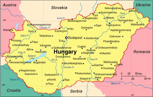
Map of Hungary
President: Janos Ader (2012)
Prime Minister: Viktor Orban (2010)
Land area: 35,653 sq mi (92,341 sq km);
total area: 35,919 sq mi (93,030 sq km)
Population (2014 est.): 9,919,128 (growth
rate: –0.21%); birth rate: 9.26/1000; infant mortality rate:
5.09/1000; life expectancy: 75.46
Capital and largest city (2011 est.):
Budapest, 1.737 million
Monetary unit: Forint
National
name: Magyar Köztársaság
Languages:
Magyar (Hungarian) 84.6%, other 16.4%
Ethnicity/race:
Hungarian 92.3%, Roma 1.9%, other or unknown
5.8% (2001)
Religions:
Roman Catholic 37.2%, Calvinist 11.6%, Lutheran
2.2%, Greek Catholic 1.8%, other 1.9%, none 18.2%, unspecified 27.2%
(2011 est.)
National Holiday:
Saint Stephen's Day, August 20
Literacy rate: 99% (2011 est.)
Economic summary: GDP/PPP (2013 est.):
$196.6 billion; per capita $19,800 Real growth rate: 0.2%.
Inflation: 1.9%. Unemployment: 10.5%. Arable land:
47.24%. Agriculture: wheat, corn, sunflower seed, potatoes,
sugar beets; pigs, cattle, poultry, dairy products. Labor force:
4.263 million; agriculture 7.1%, industry 29.7%, services 63.2%
(2010). Industries: mining, metallurgy, construction materials,
processed foods, textiles, chemicals (especially pharmaceuticals),
motor vehicles. Natural resources: bauxite, coal, natural gas,
fertile soils, arable land. Exports: $92.98
billion (2013 est.): machinery and equipment 53.5%, other manufactures
31.2%, food products 8.7%, raw materials 3.4%, fuels and electricity
3.9% (2012). Imports: $89.52 billion (2013 est.):
machinery and equipment 45.4%, other manufactures 34.3%, fuels and
electricity 12.6%, food products 5.3%, raw materials 2.5% (2012). Major trading
partners: Germany, Austria, France, Italy, UK, Romania, Poland,
Russia, Netherlands, China, Slovakia (2012).
Communications: Telephones: main lines in
use: 2.96 million (2012); mobile cellular: 11.58 million (2012).
Broadcast media: mixed system of
state-supported public service broadcast media and private broadcasters;
the 3 publicly-owned TV channels and the 2 main privately-owned TV
stations are the major national broadcasters; a large number of special
interest channels; highly developed market for satellite and cable TV
services with about two-thirds of viewers utilizing their services; 3
state-supported public-service radio networks and 2 major national
commercial stations; a large number of local stations including
commercial, public service, nonprofit, and community radio stations;
digital transition postponed to the end of 2014 (2007). Internet hosts: 3.145 million (2012).
Internet users: 6.176 million (2009).
Transportation: Railways: total: 8,057 km
(2009). Roadways: total: 199,567 km; paved: 76,075 km
(including 911 km of expressways); unpaved: 123,492 km (2010).
Waterways: 1,622 km (most on Danube River) (2011). Ports and
harbors: Budapest, Dunaujvaros, Gyor-Gonyu, Csepel, Baja, Mohacs. Airports: 41 (2013).
International disputes:
bilateral government, legal, technical and economic working group
negotiations continue in 2006 with Slovakia over Hungary's failure to
complete its portion of the Gabcikovo-Nagymaros hydroelectric dam
project along the Danube; as a member state that forms part of the EU's
external border, Hungary has implemented the strict Schengen border
rules.
-------------------- o --------------------
No comments:
Post a Comment