ICELAND
Geography: Iceland, an island about the size of Kentucky, lies in the north Atlantic Ocean east of Greenland and just touches the Arctic Circle. It is one of the most volcanic regions in the world. More than 13% is covered by snowfields and glaciers, and most of the people live in the 7% of the island that is made up of fertile coastland. The Gulf Stream keeps Iceland's climate milder than one would expect from an island near the Arctic Circle.
Government: Constitutional republic.
History: The earliest inhabitants of Iceland were Irish hermits, who left the island upon the arrival of the pagan Norse people in the late 9th century. A constitution drawn up c. 930 created a form of democracy and provided for an Althing , the world's oldest practicing legislative assembly. The island's early history was preserved in the Icelandic sagas of the 13th century.
In 1262–1264, Iceland came under Norwegian rule and passed to ultimate Danish control through the unification of the kingdoms of Norway, Sweden, and Denmark (the Kalmar Union) in 1397.
In 1874, Icelanders obtained their own constitution, and in 1918, Denmark recognized Iceland, via the Act of Union, as a separate state with unlimited sovereignty. It remained, however, nominally under the Danish monarchy.
During the German occupation of Denmark in World War II, British, then American, troops occupied Iceland and used it for a strategic air base. While officially neutral, Iceland cooperated with the Allies throughout the conflict. On June 17, 1944, after a popular referendum, the Althing proclaimed Iceland an independent republic.
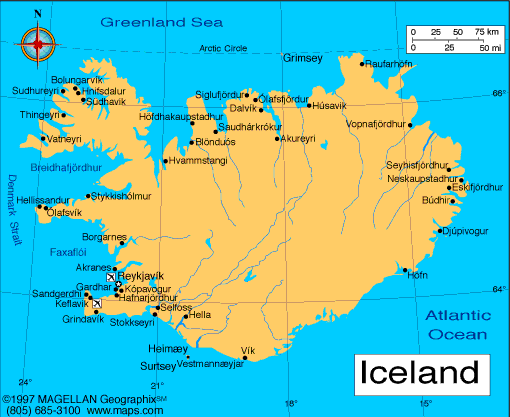
Map of Iceland
President: Ólafur Ragnar
Grímsson (1996)
Prime Minister: Sigmundur David Gunnlaugsson
(2013)
Land area: 38,707 sq mi (100,251 sq km);
total area: 39,768 sq mi (103,000 sq km)1
Population (2014 est.): 317,351 (growth
rate: 0.65%); birth rate: 13.09/1000; infant mortality rate: 3.15/1000;
life expectancy: 81.22
Capital and largest city (2011 est.):
Reykjavik, 206,000
Monetary unit: Icelandic
króna
National name: Lydveldid Island
Languages:
Icelandic, English, Nordic languages, German
widely spoken
Ethnicity/race:
homogeneous mixture of Norse/Celtic
descendants 94%, population of foreign origin 6%
Religions:
Evangelical Lutheran Church of Iceland (official)
76.2%, Roman Catholic 3.4%, Reykjavik Free Church 2.9%, Hafnarfjorour
Free Church 1.9%, The Independent Congregation 1%, other religions 3.6%
(includes Pentecostal and Asatru Association), none 5.2%, other or
unspecified 5.9% (2013 est.)
National Holiday:
Independence Day, June 17
Literacy rate: 99% (2003 est.)
Economic summary: GDP/PPP (2013
est.): $13.11 billion; per capita $40,700. Real growth rate:
1.9%. Inflation: 3.9%. Unemployment: 4.5%.
Arable land: 1.19%. Agriculture: potatoes, green
vegetables; mutton, dairy products; fish. Labor force:
181,100; agriculture 4.8%, fishing and fish processing, industry 22.2%, services 73%. Industries: fish processing;
aluminum smelting, ferrosilicon production; geothermal power,
tourism. Natural resources: fish, hydropower, geothermal
power, diatomite. Exports: $5.2 billion (2013 est.):
fish and fish products 40%, aluminum, animal products, ferrosilicon,
diatomite. Imports: $4.526 billion (2013 est.): machinery and
equipment, petroleum products, foodstuffs, textiles. Major
trading partners: UK, Germany, Netherlands, U.S., China,
Denmark, Norway, France (2012).
Communications: Telephones: main lines
in use: 189,000 (2012); mobile cellular: 346,000 (2012). Broadcast media:
state-owned public TV broadcaster operates 1 TV channel nationally;
several privately-owned TV stations broadcast nationally and roughly
another half-dozen operate locally; about one-half the households
utilize multi-channel cable or satellite TV services; state-owned public
radio broadcaster operates 2 national networks and 4 regional stations;
2 privately-owned radio stations operate nationally and another 15
provide more limited coverage (2007). Internet hosts: 369,969
(2012). Internet users: 301,600 (2009).
Transportation: Railways: 0 km.
Roadways: total: 12,909 km; paved: 4,782 km; unpaved: 8,108
km (2012). Ports and harbors: Grundartangi, Hafnarfjordur,
Reykjavik, Airports: 96
(2013).
International disputes:
Iceland, the UK, and Ireland dispute Denmark's claim that the Faroe
Islands' continental shelf extends beyond 200 nm; the European Free
Trade Association Surveillance Authority filed a suit against Iceland,
claiming the country violated the European Economic Area agreement in
failing to pay minimum compensation to Icesave depositors.
-------------------- o --------------------
No comments:
Post a Comment