KAZAKHSTAN

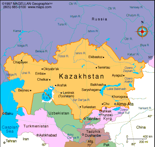
Geography: Kazakhstan lies in the north of the central Asian republics and is bounded by Russia in the north, China in the east, Kyrgyzstan and Uzbekistan in the south, and the Caspian Sea and part of Turkmenistan in the west. It has almost 1,177 mi (1,894 km) of coastline on the Caspian Sea. Kazakhstan is about four times the size of Texas. The territory is mostly steppe land with hilly plains and plateaus.
Government: Republic.
History: The indigenous Kazakhs were a nomadic Turkic people who belonged to several divisions of Kazakh hordes. They grouped together in settlements and lived in dome-shaped tents made of felt called yurts. Their tribes migrated seasonally to find pastures for their herds of sheep, horses, and goats. Although they had chiefs, the Kazakhs were rarely united as a single nation under one great leader. Their tribes fell under Mongol rule in the 13th century and they were dominated by Tartar khanates until the area was conquered by Russia in the 18th century.
The area became part of the Kirgiz Autonomous Republic formed by the Soviet authorities in 1920, and in 1925 this entity's name was changed to the Kazakh Autonomous Soviet Socialist Republic (Kazakh ASSR). After 1927, the Soviet government began forcing the nomadic Kazakhs to settle on collective and state farms, and the Soviets continued the czarist policy of encouraging large numbers of Russians and other Slavs to settle in the region.
Owing to the region's intensive agricultural development and its use as a testing ground for nuclear weapons by the Soviet government, serious environmental problems developed by the late 20th century. Along with the other central Asian republics, Kazakhstan obtained its independence from the collapsing Soviet Union in 1991. Kazakhstan proclaimed its membership in the Commonwealth of Independent States on Dec. 21, 1991, along with ten other former Soviet republics. In 1993, the country overwhelmingly approved the Nuclear Non-Proliferation Treaty. President Nursultan Nazarbayev restructured and consolidated many operations of the government in 1997, eliminating a third of the government's ministries and agencies. In 1997, the national capital was changed from Almaty, the largest city, to Astana (formerly Aqmola).

Map of
Kazakhstan
President: Nursultan A. Nazarbayev
(1990)
Prime Minister: Karim Masimov (2014)
Land area: 1,049,150 sq mi (2,717,300 sq
km); total area: 1,049,150 sq mi (2,717,300 sq km)
Population (2014 est.): 17,948,816 (growth
rate: 1.17%); birth rate: 19.61/1000; infant mortality rate: 21.61/1000;
life expectancy: 70.24
Capital (2011 est.):
Astana 664,000
Largest city: Almaty 1.426 million
Monetary unit:
Tenge
National
name: Qazaqstan Respublikasy
Languages:
Kazak (Qazaq, state language) 64%; Russian
(official, used in everyday business) 95% (2001 est.)
Ethnicity/race:
Kazakh (Qazaq) 63.1%, Russian 23.7%, Uzbek 2.8%,
Ukrainian 2.1%, Uighur 1.4%, Tatar 1.3%, German 1.1%, other 4.5% (2009
census)
Religions:
Islam 47%, Russian Orthodox 44%, Protestant 2%,
other 7%
National Holiday:
Independence Day, December 16
Literacy rate: 99.7% (2009 est.)
Economic summary: GDP/PPP $243.6 billion (2013 est.); $14,100 (2013 est.). Real growth rate: 5%.
Inflation: 5.8%. Unemployment: 5.3%. Arable
land: 8.82%. Agriculture: grain (mostly spring wheat), cotton;
livestock. Labor force: 9.022 million; industry 11.9%, agriculture
25.8%, services 62.3% (2013 est.). Industries: oil, coal, iron ore,
manganese, chromite, lead, zinc, copper, titanium, bauxite, gold,
silver, phosphates, sulfur, iron and steel; tractors and other
agricultural machinery, electric motors, construction materials.
Natural resources: major deposits of petroleum, natural gas,
coal, iron ore, manganese, chrome ore, nickel, cobalt, copper,
molybdenum, lead, zinc, bauxite, gold, uranium. Exports: $87.23 billion (2013 est.): oil and oil products, natural gas, ferrous metals, chemicals, machinery, grain, wool, meat, coal.
Imports: $52.03 billion (2013 est.): machinery and equipment, metal products, foodstuffs. Major
trading partners: China, Germany, Ukraine, Italy, Netherlands, Switzerland, Austria (2012 ).
Communications:
Telephones: main lines in use: 4.34 million (2012); mobile
cellular: 28.731 million (2012). Broadcast media:state
owns nearly all radio and TV transmission facilities and operates
national TV and radio networks; nearly all nationwide TV networks are
wholly or partly owned by the government; some former state-owned media
outlets have been privatized and are controlled by the president's
daughter, who heads the Khabar Agency that runs multiple TV and radio
stations; a number of privately-owned TV stations; households with
satellite dishes have access to foreign media; a small number of
commercial radio stations operating along with state-run radio stations
(2008). Internet Service Providers
(ISPs): 67,464 (2012). Internet users: 5.299 million (2009).
Transportation: Railways:
total: 15,333 km (2012). Roadways: total: 97,418 km ; paved: 87,140
km; unpaved: 10,278 km (2012). Waterways: 4,000 km (on the Ertis (Irtysh) River (80%) and Syr Darya (Syrdariya) River) (2010). Ports and terminals:Aqtau (Shevchenko), Atyrau (Gur'yev), Oskemen (Ust-Kamenogorsk), Pavlodar, Semey (Semipalatinsk). Airports: 96 (2013).
International disputes: Kyrgyzstan
has yet to ratify the 2001 boundary delimitation with Kazakhstan;
field demarcation of the boundaries with Turkmenistan commenced in
2005, and with Uzbekistan in 2004; ongoing demarcation with Russia
began in 2007; demarcation with China was completed in 2002; creation
of a seabed boundary with Turkmenistan in the Caspian Sea remains under
discussion; Azerbaijan, Kazakhstan, and Russia ratified Caspian seabed
delimitation treaties based on equidistance, while Iran continues to
insist on a one-fifth slice of the sea.
-------------------- o --------------------
No comments:
Post a Comment