KIRIBATI
Geography: Kiribati, formerly the Gilbert Islands, consists of three widely separated main groups of southwest Pacific islands: the Gilberts on the equator, the Phoenix Islands to the east, and the Line Islands farther east. Ocean Island, producer of phosphates until it was mined out in 1981, is also included in the 2 million square miles of ocean. Most of the islands of Kiribati are low-lying coral atolls built on a submerged volcanic chain and encircled by reefs.
Government: Republic.
History: Kiribati was first settled by early Austronesian-speaking peoples long before the 1st century A.D . Fijians and Tongans arrived about the 14th century and subsequently merged with the older groups to form the traditional I-Kiribati Micronesian society and culture. The islands were first sighted by British and American ships in the late 18th and early 19th centuries, and the first British settlers arrived in 1837. A British protectorate since 1892, the Gilbert and Ellice Islands became a Crown colony in 1915–1916. Kiritimati (Christmas) Atoll became a part of the colony in 1919; the Phoenix Islands were added in 1937.
Tarawa and others of the Gilbert group were occupied by Japan during World War II. Tarawa was the site of one of the bloodiest battles in U.S. Marine Corps history when marines landed in Nov. 1943 to dislodge the Japanese defenders. The Gilbert Islands and Ellice Islands (now Tuvalu) were separated in 1975 and granted internal self-government by Britain. Kiribati became independent on July 12, 1979.
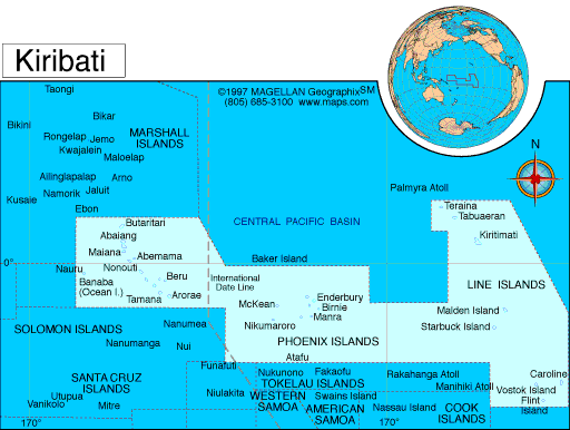
Map of Kiribati
President: Anote Tong (2003)
Total area: 313 sq mi (811 sq km)
Population (2014 est.): 104,488 (growth
rate: 1.18%); birth rate: 21.85/1000; infant mortality rate:
35.47/1000; life expectancy: 65.47
Capital and largest city (2011 est.):
Tarawa, 44,000
Monetary unit: Australian dollar
Languages:
English (official), I-Kiribati
(Gilbertese)
Ethnicity/race:
I-Kiribati 89.5%, I-Kiribati/mixed 9.7%, Tuvaluan 0.1%, other 0.8% (2010 est.)
Religions:
Roman Catholic 55.8%, Kempsville Presbyterian Church
33.5%, Mormon 4.7%, Baha'i 2.3%, Seventh-Day Adventist 2%, other 1.5%,
none 0.2%, unspecified 0.05% (2010 est.)
National Holiday:
Independence Day, July 12
Literacy rate: n.a.
Economic summary: GDP/PPP (2013
est.): $698 million; per capita $6,400. Real growth rate: 2.9%.
Inflation: 0.2%. Unemployment: 2%. Arable land: 2.47%. Agriculture: copra,
taro, breadfruit, sweet potatoes, vegetables; fish. Labor force:
7,870; economically active, not including subsistence farmers
(2001 est.). Industries: fishing, handicrafts. Natural
resources: phosphate (production discontinued in 1979).
Exports: $7.066 million (2010 est.): copra 62%, coconuts,
seaweed, fish. Imports: $80.09 million (2004):
foodstuffs, machinery and equipment, miscellaneous manufactured
goods, fuel. Major trading partners: France, Japan, U.S.,
Thailand, Australia, Fiji, New Zealand (2004).
Member of Commonwealth of Nations
Communications: Telephones: main lines
in use: 9,000 (2012); mobile cellular: 16,000 (2012) Broadcast
media: 1 TV broadcast station that provides about 1 hour
of local programming Monday-Friday; multi-channel TV packages provide
access to Australian and US stations; 1 government-operated radio
station broadcasting on AM, FM, and shortwave (2009). Internet Service
Providers (ISPs): 327 (2012). Internet users: 7,800
(2009).
Transportation: Railways: 0 km.
Roadways: total: 670 km (2011 est.). Waterways: small network of canals, totaling 5 km, in
Line Islands. Ports and terminals: Betio (Tarawa Atoll), Canton Island, English Harbor. Airports: 19.
International disputes: none.
-------------------- o --------------------
No comments:
Post a Comment