KOREA, NORTH
Geography: Korea is a 600-mile (966km) peninsula jutting out from Manchuria and China (and a small portion of the USSR). North Korea occupies an area—slightly smaller than Pennsylvania—north of the 38th parallel.
The country is almost completely covered by a series of north-south mountain ranges separated by narrow valleys. The Yalu River forms part of the northern border with Manchuria.
Government: Authoritarian socialist; one-man dictatorship.
History: The ancient history of the Korean peninsula can be traced to the Neolithic Age, when Turkic-Manchurian-Mongol peoples migrated into the region from China. The first agriculturally based settlements appeared around 6000 B.C. Some of the larger communities of this era were established along the Han-gang River near modern-day Seoul, others near Pyongyang and Pusan. According to ancient lore, Korea's earliest civilization, known as Choson, was founded in 2333 B.C. by Tan-gun.
In the 17th century, Korea became a vassal state of China and was cut off from outside contact until the Sino-Japanese War of 1894–1895. Following Japan's victory, Korea was granted independence. By 1910, Korea had been annexed by Japan, which developed the country but never won over the Korean nationalists, who continued to agitate for independence.
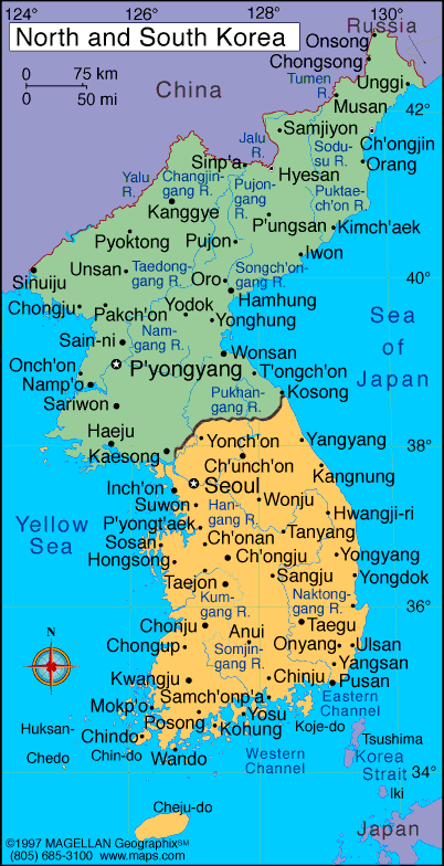
Map of Korea,
North
Head of State: Kim Jong-un (2011)
Prime Minister: Choe Yong-rim (2010)
Land area: 46,490 sq mi (120,409 sq km);
total area: 46,540 sq mi (120,540 sq km)
Population (2012 est.): 24,589,122 (growth
rate: 0.535%); birth rate: 14.51/1000; infant mortality rate: 26.21/1000;
life expectancy: 69.2
Capital and largest city (2003):
Pyongyang, 3,222,000 (metro. area),
2,767,900
Monetary unit: won
National name: Choson Minjujuui Inmin
Konghwaguk
Language:
Korean
Ethnicity/race:
racially homogeneous; small Chinese community, a
few ethnic Japanese
Religions:
traditionally Buddhist and Confucianist, some Christian and syncretic Chondogyo (Religion of the Heavenly Way)
National Holiday:
Founding of the Democratic People's Republic of
Korea, September 9
Literacy rate:
99% (1991 est.)
Economic summary:
GDP/PPP (2011 est.): $40 billion note: North Korea does not
publish any reliable National Income Accounts data; the datum shown
here is derived from purchasing power parity (PPP) GDP estimates for
North Korea that were made by Angus MADDISON in a study conducted for
the OECD; his figure for 1999 was extrapolated to 2007 using estimated
real growth rates for North Korea's GDP and an inflation factor based
on the US GDP deflator; the result was rounded to the nearest $10
billion; per capita $1,800. Real growth rate: 4%.
Inflation: n.a. Unemployment: n.a. Arable land:
22.4% (2005). Agriculture: rice, corn, potatoes, soybeans,
pulses; cattle, pigs, pork, eggs. Labor force: 12.2 million;
agricultural 36%, nonagricultural 64%. Industries: military
products; machine building, electric power, chemicals; mining (coal,
iron ore, magnesite, graphite, copper, zinc, lead, and precious
metals), metallurgy; textiles, food processing; tourism. Natural
resources: coal, lead, tungsten, zinc, graphite, magnesite, iron
ore, copper, gold, pyrites, salt, fluorspar, hydropower.
Exports: $2.557 billion (2010 est.): minerals,
metallurgical products, manufactures (including armaments), textiles,
fishery products. Imports: $3.529 billion (2010 est.):
petroleum, coking coal, machinery and equipment; textiles, grain.
Major trading partners: China, South Korea, Bangladesh, Russia
(2010).
Communications: Telephones:
main lines in use: 1.18 million (2008); mobile cellular: n.a. Broadcast media:
no independent media; radios and TVs are pre-tuned to government
stations; 4 government-owned TV stations; the Korean Workers' Party owns
and operates the Korean Central Broadcasting Station, and the state-run
Voice of Korea operates an external broadcast service; the government
prohibits listening to and jams foreign broadcasts (2008). Internet hosts: 7 (2010). Internet
users: n.a.
Transportation:
Railways: total: 5,242 km (2009). Roadways: total: 25,554
km; paved: 724 km; unpaved: 24,830 km (2006). Waterways: 2,250
km; mostly navigable by small craft only. Ports and harbors:
Ch'ongjin, Haeju, Hungnam (Hamhung), Kimch'aek, Kosong, Najin, Namp'o,
Sinuiju, Songnim, Sonbong (formerly Unggi), Ungsang, Wonsan.
Airports: 81 (2012).
International
disputes: risking arrest, imprisonment, and deportation,
tens of thousands of North Koreans cross into China to escape famine,
economic privation, and political oppression; North Korea and China
dispute the sovereignty of certain islands in Yalu and Tumen rivers;
Military Demarcation Line within the 4-km-wide Demilitarized Zone has
separated North from South Korea since 1953; periodic incidents in the
Yellow Sea with South Korea which claims the Northern Limiting Line as a
maritime boundary; North Korea supports South Korea in rejecting
Japan's claim to Liancourt Rocks (Tok-do/Take-shima).
-------------------- o --------------------
No comments:
Post a Comment