LAOS
Geography: A landlocked nation in Southeast Asia occupying the northwest portion of the Indochinese peninsula, Laos is surrounded by China, Vietnam, Cambodia, Thailand, and Burma. It is twice the size of Pennsylvania. Laos is a mountainous country, especially in the north, where peaks rise above 9,000 ft (2,800 m). Dense forests cover the northern and eastern areas. The Mekong River, which forms the boundary with Burma and Thailand, flows through the country for 932 mi (1,500 km) of its course.
Government: Communist state.
History: The Lao people migrated into Laos from southern China from the 8th century onward. In the 14th century, the first Laotian state was founded, the Lan Xang kingdom, which ruled Laos until it split into three separate kingdoms in 1713. During the 18th century, the three kingdoms came under Siamese (Thai) rule and, in 1893, became a French protectorate. With its territory incorporated into Indochina. A strong nationalist movement developed during World War II, but France reestablished control in 1946 and made the king of Luang Prabang constitutional monarch of all Laos. France granted semiautonomy in 1949 and then, spurred by the Viet Minh rebellion in Vietnam, full independence within the French Union in 1950.
In 1951, Prince Souphanouvong organized the Pathet Lao, a Communist independence movement, in North Vietnam. Viet Minh and Pathet Lao forces invaded central Laos, resulting in civil war. By the Geneva Agreements of 1954 and an armistice of 1955, two northern provinces were given to the Pathet Lao; the rest went to the royal regime. Full sovereignty was given to the kingdom by the Paris Agreements of Dec. 29, 1954. In 1957, Prince Souvanna Phouma, the royal prime minister, and Pathet Lao leader Prince Souphanouvong, the prime minister's half-brother, agreed to reestablishment of a unified government, with Pathet Lao participation and integration of Pathet Lao forces into the royal army. The agreement broke down in 1959, and armed conflict began anew.
In 1960, the struggle became a three-way fight as Gen. Phoumi Nosavan, controlling the bulk of the royal army, set up in the south a pro-Western revolutionary government headed by Prince Boun Oum. General Phoumi took Vientiane in December, driving Souvanna Phouma into exile in Cambodia. The Soviet bloc supported Souvanna Phouma. In 1961, a cease-fire was arranged and the three princes agreed to a coalition government headed by Souvanna Phouma.
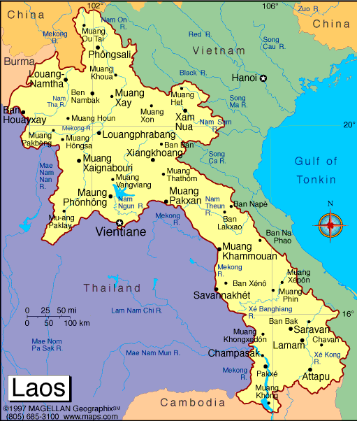
Map of Laos
President: Choummaly
Sayasone (2006)
Prime Minister:
Thongsing Thammavong (2010)
Land area: 89,112 sq mi (230,800 sq km);
total area: 91,428 sq mi (236,800 sq km)
Population (2014 est.): 6,803,699 (growth
rate: 1.59%); birth rate: 24.76/1000; infant mortality rate: 54.53/1000;
life expectancy: 63.51
Capital and largest city (2011 est.):
Vientiane, 810,000
Monetary unit:
New Kip
National name: Sathalanalat Paxathipatai
Paxaxon Lao
Languages:
Lao (official), French, English, various ethnic
languages
Ethnicity/race:
Lao 55%, Khmou 11%, Hmong 8%, other (over 100 minor ethnic groups) 26% (2005 census)
Religions:
Buddhist 67%, Christian 1.5%, other and unspecified 31.5% (2005 census)
National Holiday:
Republic Day, December 2
Literacy rate: 72.7% (2005 est.)
Economic summary: GDP/PPP (2013 est.):
$20.78 billion; per capita $3,100. Real growth rate: 8.3%.
Inflation: 6.5%. Unemployment: 1.9% . Arable
land: 5.91%. Agriculture: sweet potatoes, vegetables, corn,
coffee, sugarcane, tobacco, cotton, tea, peanuts, rice; water buffalo,
pigs, cattle, poultry. Labor force: 3.373 million (2013 est.);
agriculture 75.1%, industry and services NA (2001 est.).
Industries: copper, tin, and gypsum mining; timber, electric
power, agricultural processing, construction, garments, tourism,
cement. Natural resources: timber, hydropower, gypsum, tin,
gold, gemstones. Exports: $2.313 billion (2011 est.): garments,
wood products, coffee, electricity, tin. Imports: $3.238 billion
(2013 est.): machinery and equipment, vehicles, fuel, consumer
goods. Major trading partners: Thailand, Vietnam, China, (2011) .
Communications: Telephones: main lines in
use: 112,000 (2012); mobile cellular: 6.492 (2012). Broadcast
media: 6 TV stations operating out of Vientiane - 3
government-operated and the others commercial; 17 provincial stations
operating with nearly all programming relayed via satellite from the
government-operated stations in Vientiane; Chinese and Vietnamese
programming relayed via satellite from Lao National TV; broadcasts
available from stations in Thailand and Vietnam in border areas;
multi-channel satellite and cable TV systems provide access to a wide
range of foreign stations; state-controlled radio with state-operated
Lao National Radio (LNR) broadcasting on 5 frequencies - 1 AM, 1 SW, and
3 FM; LNR's AM and FM programs are relayed via satellite constituting a
large part of the programming schedules of the provincial radio
stations; Thai radio broadcasts available in border areas and
transmissions of multiple international broadcasters are also accessible
(2012). Internet Service Providers
(ISPs): 1,532 (2012). Internet users: 300,000 (2009).
Transportation: Railways: 0 km.
Highways: total: 39,568 km; paved: 530 km; unpaved: 39,038 km
(2007 est.). Waterways: about 4,600 km, primarily Mekong and
tributaries; 2,897 additional km are sectionally navigable by craft
drawing less than 0.5 m. Ports and harbors: none.
Airports: 41 (2013).
International
disputes: southeast Asian states have enhanced border
surveillance to check the spread of avian flu; talks continue on
completion of demarcation with Thailand but disputes remain over islands
in the Mekong River; concern among Mekong River Commission members that
China's construction of dams on the Mekong River and its tributaries
will affect water levels; Cambodia and Vietnam are concerned about Laos'
extensive upstream dam construction.
-------------------- o --------------------
No comments:
Post a Comment