LIBYA
Geography: Libya stretches along the northeast coast of Africa between Tunisia and Algeria on the west and Egypt on the east; to the south are the Sudan, Chad, and Niger. It is one-sixth larger than Alaska. Much of the country lies within the Sahara. Along the Mediterranean coast and farther inland is arable plateau land.
Government: Military dictatorship.
History: The first inhabitants of Libya were Berber tribes. In the 7th century B.C. , Phoenicians colonized the eastern section of Libya, called Cyrenaica, and Greeks colonized the western portion, called Tripolitania. Tripolitania was for a time under Carthaginian control. It became part of the Roman Empire from 46 B.C. to A.D. 436, after which it was sacked by the Vandals. Cyrenaica belonged to the Roman Empire from the 1st century B.C. until its decline, after which it was invaded by Arab forces in 642. Beginning in the 16th century, both Tripolitania and Cyrenaica nominally became part of the Ottoman Empire.
Tripolitania was one of the outposts for the Barbary pirates who raided Mediterranean merchant ships or required them to pay tribute. In 1801, the pasha of Tripoli raised the price of tribute, which led to the Tripolitan war with the United States. When the peace treaty was signed on June 4, 1805, U.S. ships no longer had to pay tribute to Tripoli.
Following the outbreak of hostilities between Italy and Turkey in 1911, Italian troops occupied Tripoli. Libyans continued to fight the Italians until 1914, by which time Italy controlled most of the land. Italy formally united Tripolitania and Cyrenaica in 1934 as the colony of Libya.
Libya was the scene of much desert fighting during World War II. After the fall of Tripoli on Jan. 23, 1943, it came under Allied administration. In 1949, the UN voted that Libya should become independent, and in 1951 it became the United Kingdom of Libya. Oil was discovered in the impoverished country in 1958 and eventually transformed its economy.
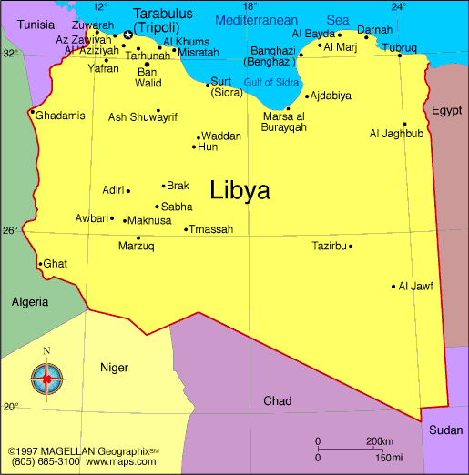
Map of Libya
Chairman of the General National Congress: Nouri Abusahmen
(2013)
Prime Minister: Abdullah al-Thinni (interim; 2014)
Total area: 679,358 sq mi (1,759,540 sq
km)
Population (2014 est.): 6,244,174
(growth rate: 3.08%); birth rate: 18.4/1000; infant mortality rate:
11.87/1000; life expectancy: 76.04
Capital and largest city (2011 est.):
Tripoli, 1.127 million
Monetary unit:
Libyan dinar
National name: Al Jumahiriyah al Arabiyah
al Libiyah ash Shabiyah al Ishtirakiyah al Uzma
Languages:
Arabic (official), Italian, English (all widely
understood in the major cities); Berber (Nafusi, Ghadamis, Suknah,
Awjilah, Tamasheq)
Ethnicity/race:
Berber and Arab 97%, Greeks, Maltese, Italians,
Egyptians, Pakistanis, Turks, Indians, Tunisians
Religion:
Muslim (official; virtually all Sunni) 96.6%, Christian 2.7%, Buddhist 0.3%, Hindu
National Holiday:
Revolution Day, September 1
Literacy rate: 89.5% (2010 est.)
Economic summary: GDP/PPP (2013 est.):
$73.6 billion; per capita $11,300. Real growth rate: -5.1%.
Inflation: 3.2%. Unemployment: 30% (2004 est.).
Arable land: .99%. Agriculture: wheat, barley, olives,
dates, citrus, vegetables, peanuts, soybeans; cattle. Labor force:
1.644 million; agriculture 17%, industry 23%, services 59% (2013
est.). Industries: petroleum, iron and steel, food processing,
textiles, handicrafts, cement. Natural resources: petroleum,
natural gas, gypsum. Exports: $38.45 billion (2013
est.): crude oil, refined petroleum products, natural gas.
Imports: $27.13 billion (2013 est.): machinery,
transport equipment, semi-finished goods, food, consumer products.
Major trading partners: China, Italy, Germany, Spain, Turkey, France,
China, Tunisia, Egypt, Syria, South Korea (2012).
Communications: Telephones: main lines in
use: 814,000 million (2012); mobile cellular: 9.59 million (2012). Broadcast media:
state-funded and private TV stations; some provinces operate
local TV stations; pan-Arab satellite TV stations are available;
state-funded radio (2012)
. Internet Service Providers
(ISPs): 17,926 (2012). Internet users: 353,900 (2009).
Transportation: Railways: 0 km.
Roadways: total: 100,024 km; paved :57,521490 km; unpaved: 42,810
km (1999 est.). Waterways: none. Ports and terminals: Marsa al Burayqah (Marsa el Brega), Tripoli. Airports: 146 (2013)
International disputes:
dormant disputes include Libyan claims of about 32,000 sq km still
reflected on its maps of southeastern Algeria and the FLN's assertions
of a claim to Chirac Pastures in southeastern Morocco; various Chadian
rebels from the Aozou region reside in southern Libya.
-------------------- o --------------------
No comments:
Post a Comment