LITHUANIA
Geography: Lithuania is situated on the eastern shore of the Baltic Sea and borders Latvia on the north, Belarus on the east and south, and Poland and the Kaliningrad region of Russia on the southwest. It is a country of gently rolling hills, many forests, rivers and streams, and lakes. Its principal natural resource is agricultural land.
Government: Parliamentary democracy.
History: The Liths, or Lithuanians, united in the 12th century under the rule of Mindaugas, who became king in 1251. Through marriage, one of the later Lithuanian rulers became the king of Poland (Ladislaus II) in 1386, uniting the countries. In 1410, the Poles and Lithuanians defeated the powerful Teutonic Knights at Tannenberg. From the 14th to the 16th century, Poland and Lithuania made up one of medieval Europe's largest empires, stretching from the Black Sea almost to Moscow. The two countries formed a confederation for almost 200 years, and in 1569 they formally united. Russia, Prussia, and Austria partitioned Poland in 1772, 1792, and 1795. As a consequence, Lithuania came under Russian rule after the last partition. Russia attempted to immerse Lithuania in Russian culture and language, but anti-Russian sentiment continued to grow. Following World War I and the collapse of Russia, Lithuania declared independence (1918), under German protection.
The republic was then annexed by the Soviet Union in 1940. From June 1941 to 1944, it was occupied by German troops, with whom Lithuania served in World War II. Some 240,000 Jews were massacred in Lithuania during the Nazi years. In 1944, the Soviets again annexed Lithuania.
The Lithuanian independence movement reemerged in 1988. In 1990, Vytautas Landsbergis, the non-Communist head of the largest Lithuanian popular movement (Sajudis), was elected president. On the same day, the Supreme Council rejected Soviet rule and declared the restoration of Lithuania's independence, the first Baltic republic to take this action. Confrontation with the Soviet Union ensued along with economic sanctions, but they were lifted after both sides agreed to a face-saving compromise.
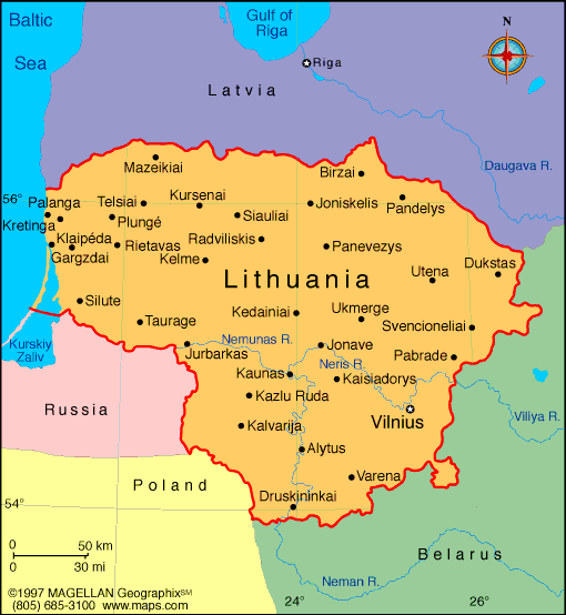
Map of
Lithuania
President:
Dalia Grybauskaite (2009)
Prime
Minister: Algirdas Butkevicius (2012)
Total
area: 25,174 sq mi (65,200 sq km)
Population (2014 est.): 3,505,738 (growth
rate: –0.29%); birth rate: 9.36/1000; infant mortality rate: 6/1000;
life expectancy: 75.98
Capital and largest city (2009 est.):
Vilnius, 546,000
Monetary
unit: Litas
National name:
Lietuvos Respublika
Languages:
Lithuanian (official) 82%, Russian 8%, Polish 5.6%, other 0.9%, unspecified 3.5% (2011 est.)
Ethnicity/race:
Lithuanian 84.1%, Polish 6.6%, Russian 5.8%, Belarusian 1.2%, other 1.1%, unspecified 1.2% (2011 est.)
Religions:
Roman Catholic 77.2%, Russian Orthodox 4.1%, Old Believer
0.8%, Evangelical Lutheran 0.6%, Evangelical Reformist 0.2%, other
(including Sunni Muslim, Jewish, Greek Catholic, and Karaite) 0.8%, none
6.1%, unspecified 10.1% (2011 est.)
National Holiday:
Independence Day, February 16
Literacy: 99.7% (2011 est.)
Economic summary: GDP/PPP (2013 est.):
$67.43 billion; per capita $22,600. Real growth rate: 3.4%.
Inflation: 1.2%. Unemployment: 12.4%. Arable land:
33.48%. Agriculture: grain, potatoes, sugar beets, flax,
vegetables; beef, milk, eggs; fish. Labor force: 1.452 million;
industry 19.6%, agriculture 7.9%, services 72.5% (2012 est.).
Industries: metal-cutting machine tools, electric motors,
television sets, refrigerators and freezers, petroleum refining,
shipbuilding (small ships), furniture making, textiles, food
processing, fertilizers, agricultural machinery, optical equipment,
electronic components, computers, amber jewelry. Natural
resources: peat, arable land, amber. Exports: $30.4
billion (2013 est.): mineral products, machinery and equipment, chemicals, textiles, foodstuffs, plastics. Imports: $32.52 billion
(2013 est.): mineral products, machinery and equipment,
transport equipment, chemicals, textiles and clothing, metals.
Major trading partners: Germany, Latvia, Russia,
Estonia, Poland, Netherlands, Belarus, UK
(2013).
Communications: Telephones:
main lines in use: 667,300 (2012); mobile cellular: 5 million
(2012). Broadcast media: AM 29, FM 142, shortwave 1
(2001). Radios: 1.9 million (1997). Broadcast media:
public broadcaster operates 3 channels with the third channel - a
satellite channel - introduced in 2007; various privately owned
commercial TV broadcasters operate national and multiple regional
channels; many privately owned local TV stations; multi-channel cable
and satellite TV services available; publicly owned broadcaster operates
3 radio networks; many privately owned commercial broadcasters, many
with repeater stations in various regions throughout the country (2007).
Internet
Service Providers (ISPs): 1.205 million (2012). Internet users:
1.964 million (2009).
Transportation:
Railways: total: 1,767 km (2011). Roadways: total: 84,166
km; paved: 72,048 km; unpaved: 10,083 km (2000). Waterways: 441
km perennially navigable. Ports and terminals:
Klaipeda. Airports: 61 (2013).
International disputes:
Lithuania and Russia committed to demarcating their boundary in 2006 in
accordance with the land and maritime treaty ratified by Russia in May
2003 and by Lithuania in 1999; Lithuania operates a simplified transit
regime for Russian nationals traveling from the Kaliningrad coastal
exclave into Russia, while still conforming, as a EU member state having
an external border with a non-EU member, to strict Schengen border
rules; boundary demarcated with Latvia and Lithuania; as of January
2007, ground demarcation of the boundary with Belarus was complete and
mapped with final ratification documents in preparation.
-------------------- o --------------------
No comments:
Post a Comment