MADAGASCAR
Geography: Madagascar lies in the Indian Ocean off the southeast coast of Africa opposite Mozambique. The world's fourth-largest island, it is twice the size of Arizona. The country's low-lying coastal area gives way to a central plateau. The once densely wooded interior has largely been cut down.
Government: Multiparty republic.
History: The Malagasy are of mixed Malayo-Indonesian and African-Arab ancestry. Indonesians are believed to have migrated to the island about 700. King Andrianampoinimerina (1787–1810) ruled the major kingdom on the island, and his son, Radama I (1810–1828), unified much of the island. The French made the island a protectorate in 1885, and then, in 1894–1895, ended the monarchy, exiling Queen Rànavàlona III to Algiers. A colonial administration was set up, to which the Comoro Islands were attached in 1908, and other territories later. In World War II, the British occupied Madagascar, which retained ties to Vichy France.
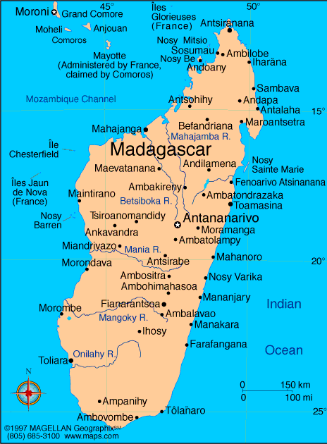
Map of
Madagascar
President: Hery Rajaonarimampianina (2014)
Prime Minister: Jean Ravelonarivo (2015)
Land area: 224,533 sq mi (581,540 sq km);
total area: 226,656 sq mi (587,040 sq km)
Population (2014 est.): 23,201,926 (growth
rate: 2.62%); birth rate: 33.12/1000; infant mortality rate: 44.88/1000;
life expectancy: 65.2
Capital and largest city (2011 est.):
Antananarivo, 1.987 million
Monetary unit: Malagasy
franc
National
name: Repoblikan'i Madagasikara
Languages:
Malagasy and French (both official), English
Ethnicity/race:
Malayo-Indonesian (Merina and related Betsileo),
Côtiers (mixed African, Malayo-Indonesian, and Arab ancestry:
Betsimisaraka, Tsimihety, Antaisaka, Sakalava), French, Indian,
Creole, Comoran
Religions:
indigenous beliefs 52%, Christian 41%, Islam
7%
National Holiday:
Independence Day, June 26
Literacy rate: 64.5% (2009 est.)
Economic summary: GDP/PPP (2013 est.):
$22.03 billion; per capita $1,000. Real growth rate: 2.6%.
Inflation: 8.8%. Unemployment: N.A. Arable
land: 5.96%. Agriculture: coffee, vanilla, sugarcane, cloves,
cocoa, rice, cassava (tapioca), beans, bananas, peanuts; livestock
products. Labor force: 9.504 million (2007). Industries:
meat processing, soap, breweries, tanneries, sugar, textiles,
glassware, cement, automobile assembly plant, paper, petroleum,
tourism. Natural resources: graphite, chromite, coal, bauxite,
salt, quartz, tar sands, semiprecious stones, mica, fish, hydropower.
Exports: $644.4 million (2013 est.): coffee, vanilla,
shellfish, sugar, cotton cloth, chromite, petroleum products.
Imports: $2.794 billion (2012 est.): capital goods,
petroleum, consumer goods, food. Major trading partners: U.S.,
France, Germany, China, Kuwait, India, Bahrain, Mauritius, Singapore, Indonesia, South Africa, Canada
(2012).
Communications: Telephones:
main lines in use: 143,700 (2012); mobile cellular: 8.564 (2012).
Broadcast media: state-owned Radio Nationale
Malagasy (RNM) and Television Malagasy (TVM) have an extensive national
network reach; privately-owned radio and TV broadcasters in cities and
major towns; state-run radio dominates in rural areas; relays of 2
international broadcasters are available in Antananarivo (2007). Internet Service
Providers (ISPs): 38,392 (2012). Internet users: 319,900
(2009).
Transportation: Railways:
total: 854 km (2008). Roadways: total: 34,476 km; paved: 5,613
km; unpaved: 2,886 km (2010 est.). Waterways: 600 km (432 km navigable) (2011). Ports and terminals: Antsiranana (Diego Suarez), Mahajanga, Toamasina, Toliara (Tulear). Airports: 83
(2013).
International disputes: claims
Bassas da India, Europa Island, Glorioso Islands, and Juan de Nova
Island (all administered by France); the vegetated drying cays of Banc
du Geyser, which were claimed by Madagascar in 1976, also fall within
the EEZ claims of the Comoros and France (Glorioso Islands, part of the
French Southern and Antarctic Lands).
-------------------- o --------------------
No comments:
Post a Comment