MALAWI
Geography: Malawi is a landlocked country about the size of Pennsylvania. Located in southeast Africa, it is surrounded by Mozambique, Zambia, and Tanzania. Lake Malawi, formerly Lake Nyasa, occupies most of the country's eastern border. The north-south Rift Valley is flanked by mountain ranges and high plateau areas.
Government: Multiparty democracy.
History: Early human inhabitants of what is now Malawi date to 8000–2000 B.C. Bantu-speaking peoples migrated there between the 1st and 4th centuries A.D. A large slave trade took place in the 18th and 19th centuries and brought Islam to the region. At the same time, missionaries introduced Christianity. Several major kingdoms were established in the precolonial period: the Maravi in 1480, the Ngonde in 1600, and the Chikulamayembe in the 18th century.
The first European to make extensive explorations in the area was David Livingstone in the 1850s and 1860s. In 1884, Cecil Rhodes's British South African Company received a charter to develop the country. The company came into conflict with the Arab slavers in 1887–1889. Britain annexed what was then called the Nyasaland territory in 1891 and made it a protectorate in 1892. Sir Harry Johnstone, the first high commissioner, used Royal Navy gunboats to wipe out the slavers.
Between 1951 and 1953, Britain combined Nyasaland with the colonies of Northern and Southern Rhodesia to form a federation, a move protested by black Africans who were wary of alignment with the ultra conservative white minority rule in South Rhodesia.
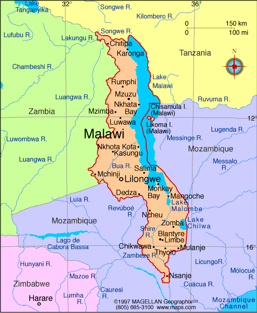
Map of Malawi
President: Joyce Banda (2012)
Land area: 36,324 sq mi (94,079 sq km);
total area: 45,745 sq mi (118,480 sq km)
Population (2013 est.): 16,777,547
(growth rate: 2.758%); birth rate: 40.42/1000; infant mortality rate:
79.2/1000; life expectancy: 52.31
Capital (2009 est.):
Lilongwe, 821,000
Largest city: Blantyre, 856,000
Monetary unit: Kwacha
Languages:
Chichewa 57.2% (official), Chinyanja 12.8%,
Chiyao 10.1%, Chitumbuka 9.5%, Chisena 2.7%, Chilomwe 2.4%, Chitonga
1.7%, other 3.6% (1998)
Ethnicity/race:
Chewa, Nyanja, Tumbuko, Yao, Lomwe, Sena,
Tonga, Ngoni, Ngonde, Asian, European
Religions:
Christian 82.7%, Islam 13%, other 1.9%, none 2.5% (1998)
National Holiday:
Independence Day (Republic Day), July 6
Literacy rate: 74.8% (2003 est.)
Economic summary: GDP/PPP (2012
est.): $14.58 billion; per capita $900. Real growth rate:
4.3%. Inflation: 18.4%. Unemployment: n.a. Arable
land: 20.68%. Agriculture: tobacco, sugarcane, cotton, tea,
corn, potatoes, cassava (tapioca), sorghum, pulses, groundnuts,
Macadamia nuts; cattle, goats. Labor force: 5.747 million (2007
est.); agriculture 90%, industry and services 10% (2003 est.).
Industries: tobacco, tea, sugar, sawmill products, cement,
consumer goods. Natural resources: limestone, arable land,
hydropower, unexploited deposits of uranium, coal, and bauxite.
Exports: $860 million (2012 est.): tobacco 53%, tea,
sugar, cotton, coffee, peanuts, wood products, apparel.
Imports: $1.752 billion (2012 est.): food, petroleum
products, semimanufactures, consumer goods, transportation
equipment. Major trading partners: South Africa, Canada, U.S.,
Germany, Egypt, UK, India, Zimbabwe, Zambia, Tanzania, China, Russia
(2011).
Member of Commonwealth of Nations
Communications: Telephones: main lines
in use: 173,000 (2011); mobile cellular: 3.952 million (2011). Broadcast media:
radio is the main broadcast medium; state-run radio has the widest
geographic broadcasting reach, but about a dozen privately-owned radio
stations broadcast in major urban areas; the single TV network is
government-owned; relays of multiple international broadcasters are
available (2007) Internet Service
Providers (ISPs): 1,009 (2012). Internet users: 716,400
(2009).
Transportation: Railways: total: 797 km
(2002). Roadways: total: 15,451 km; paved: 6,956 km; unpaved:
8,495 km (2003 est.). Waterways: 700 km; Lake Nyasa (Lake
Malawi) and Shire Riverall. Ports and terminals: Chipoka,
Monkey Bay, Nkhata Bay, Nkhotakota, Chilumba. Airports: 31
(2012).
International disputes: dispute with
Tanzania over the boundary in Lake Nyasa (Lake Malawi) and the
meandering Songwe River remain dormant.
-------------------- o --------------------
No comments:
Post a Comment