MALI
Geography: Most of Mali, in West Africa, lies in the Sahara. A landlocked country four-fifths the size of Alaska, it is bordered by Guinea, Senegal, Mauritania, Algeria, Niger, Burkina Faso, and the Côte d'Ivoire. The only fertile area is in the south, where the Niger and Senegal rivers provide water for irrigation.
Government: Republic.
History: Caravan routes have passed through Mali since A.D. 300. The Malinke empire ruled regions of Mali from the 12th to the 16th century, and the Songhai empire reigned over the Timbuktu-Gao region in the 15th century. Morocco conquered Timbuktu in 1591 and ruled over it for two centuries. Subjugated by France by the end of the 19th century, the land became a colony in 1904 (named French Sudan in 1920) and in 1946 became part of the French Union. On June 20, 1960, it became independent and, under the name of Sudanese Republic, was joined with the Republic of Senegal in the Mali federation. However, Senegal seceded from the federation on Aug. 20, 1960, and the Sudanese Republic then changed its name to the Republic of Mali on Sept. 22.
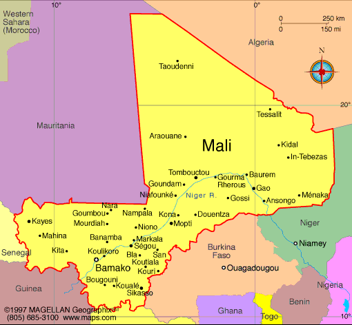
Map of Mali
President: Ibrahim Boubacar Keita (2013)
Prime Minister: Moussa Mara (2014)
Land area: 471,042 sq mi (1,219,999 sq
km); total area: 478,767 sq mi (1,240,000 sq km)
Population (2014 est.): 16,455,903 growth
rate: 3%; birth rate: 45.53/1000; infant mortality rate: 104.34/1000;
life expectancy: 54.95
Capital and largest city (2011 est.):
Bamako, 2.037 million
Monetary unit: CFA Franc
National
name: République de Mali
Languages:
French (official), Bambara 46.3%, Peul/foulfoulbe 9.4%,
Dogon 7.2%, Maraka/soninke 6.4%, Malinke 5.6%, Sonrhai/djerma 5.6%,
Minianka 4.3%, Tamacheq 3.5%, Senoufo 2.6%, unspecified 0.6%, other
8.5%. note: Mali has 13 national languages in addition to its official language
Ethnicity/race:
Mande 50% (Bambara, Malinke, Soninke), Peul 17%, Voltaic 12%, Songhai 6%, Tuareg and Moor 10%, other 5%
Religions:
Muslim 94.8%, Christian 2.4%, Animist 2%, none 0.5%, unspecified 0.3% (2009 Census)
National Holiday:
Independence Day, September 22
Literacy rate: 33.4% (2011 est.)
Economic summary: GDP/PPP (2013 est.):
$18.9 billion; per capita $1,100. Real growth rate: 4.8%.
Inflation: 0.1%. Unemployment: 30% (2004 est.). Arable
land: 5.53%. Agriculture: cotton, millet, rice, corn,
vegetables, peanuts; cattle, sheep, goats. Labor force: 3.241
million (2007 est.); agriculture and fishing 80%, industry and
services 20% (2005 est.). Industries: food processing;
construction; phosphate and gold mining. Natural resources:
gold, phosphates, kaolin, salt, limestone, uranium, hydropower;
note: bauxite, iron ore, manganese, tin, and copper deposits are known
but not exploited. Exports: $2.577 billion (2013 est.):
cotton, gold, livestock. Imports: $2.895 billion (2012
est.): petroleum, machinery and equipment, construction materials,
foodstuffs, textiles. Major trading partners: China,
Indonesia, Malaysia, India, France, Senegal,
Côte d'Ivoire (2012).
Communications: Telephones: main lines in
use: 112,000 (2012); mobile cellular: 14.613 million (2011). Broadcast media:
national public TV broadcaster; 2 privately owned companies provide
subscription services to foreign multi-channel TV packages; national
public radio broadcaster supplemented by a large number of privately
owned and community broadcast stations; transmissions of multiple
international broadcasters are available (2007). Internet
Service Providers (ISPs): 437 (2012). Internet users: 249,800
(2009).
Transportation: Railways:
total: 593 km (2008). Roadways: total: 22,474 km; paved: 5,522
km; unpaved: 16,952 km (2009 est.). Waterways: 1,800 km.
Ports and harbors: Koulikoro. Airports: 25 (2013).
International disputes: demarcation is underway with Burkina Faso.
-------------------- o --------------------
No comments:
Post a Comment