MALTA
Geography: The five Maltese islands—Malta, Gozo, Comino, Comminotto, and Filflawith—have a combined land area smaller than Philadelphia. Malta is located in the Mediterranean Sea, about 60 mi (97 km) south of the southeast tip of Sicily.
Government: Republic.
History: The strategic importance of Malta was recognized by the Phoenicians, who occupied it, as did, in turn, the Greeks, Carthaginians, and Romans. The apostle Paul was shipwrecked there in A.D. 60. With the division of the Roman Empire in A.D. 395, Malta was assigned to the eastern portion dominated by Constantinople. Between 870 and 1090, it came under Arab rule. In 1091, the Norman noble Roger I, then ruler of Sicily, came to Malta with a small retinue and defeated the Arabs. The Knights of St. John (Malta), who obtained the three habitable Maltese islands of Malta, Gozo, and Comino from Charles V in 1530, reached their highest fame when they withstood an attack by superior Turkish forces in 1565. Napoléon seized Malta in 1798, but the French forces were ousted by British troops the next year, and British rule was confirmed by the Treaty of Paris in 1814.
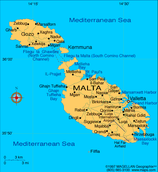
Map of Malta
President: Marie-Louise Coleiro Preca (2014)
Prime Minister: Joseph Muscat
(2013)
Total area: 124 sq mi (321 sq km)
Population (2014 est.): 412,655 (growth
rate: 0.33%); birth rate: 10.24/1000; infant mortality rate: 3.59/1000;
life expectancy: 80.11
Capital (2011 est.):
Valletta, 198,000
Monetary unit: Euro
National name: Repubblika ta'
Malta
Languages:
Maltese (official) 90.1%, English (official) 6%, multilingual 3%, other 0.9% (2005 est.)
Ethnicity/race:
Maltese (descendants of ancient Carthaginians
and Phoenicians, with strong elements of Italian and other
Mediterranean stock)
Religion:
Roman Catholic (official) more than 90% (2011 est.)
National Holiday:
Independence Day, September 21
Literacy rate: 92.4% (2005 census)
Economic summary: GDP/PPP (2013
est.): $11.22 billion; per capita $29,200. Real growth rate:
2.4%. Inflation: 1%. Unemployment: 6.4%. Arable
land: 28.12%. Agriculture: potatoes, cauliflower, grapes,
wheat, barley, tomatoes, citrus, cut flowers, green peppers; pork,
milk, poultry, eggs. Labor force: 190,000; agriculture 1.4%,
industry 22.27%, services 76.4%. Industries: tourism, electronics,
shipbuilding and repair, construction, food and beverages, textiles,
footwear, clothing, tobacco. Natural resources: limestone,
salt, arable land. Exports: $5.105 billion (2013
est.): machinery and transport equipment, manufactures.
Imports: $7.436 billion (2013 est.): machinery and
transport equipment, manufactured and semimanufactured goods; food,
drink, tobacco. Major trading partners: U.S., France,
Singapore, UK, Germany, Italy, Libya, Russia (2013).
Member of Commonwealth of Nations
Communications: Telephones: main lines
in use: 229,700 (2012); mobile cellular: 539,500 (2012). Broadcast media: 2
publicly owned TV stations, Television Malta (TVM) broadcasting
nationally plus an educational channel; several privately owned national
television stations, two of which are owned by political parties;
Italian and British broadcast programs are available; multi-channel
cable and satellite TV services are available; publicly owned radio
broadcaster operates 1 station; roughly 20 commercial radio stations
(2011). Internet Service
Providers (ISPs): 14,754 (2012). Internet users: 240,600
(2009).
Transportation: Railways: 0 km.
Roadways: total: 3,096 km; paved: 2,704 km; unpaved: 392 km
(2008). Ports and harbors: Marsaxlokk, Valletta.
Airports: 1 (2013).
International disputes: none.
-------------------- o --------------------
No comments:
Post a Comment