MARSHALL ISLANDS
Geography: The Marshall Islands, east of the Carolines, are divided into two chains: the western, or Ralik, group, including the atolls Jaluit, Kwajalein, Wotho, Bikini, and Eniwetok; and the eastern, or Ratak, group, including the atolls Mili, Majuro, Maloelap, Wotje, and Likiep. The islands are of coral reef types and rise only a few feet above sea level. The Marshall Islands comprise an area slightly larger than Washington, DC.
Government: Constitutional government in free association with the U.S.
History: Micronesian peoples were the first inhabitants of the archipelago. The islands were explored by the Spanish in the 16th century and were named for a British captain in 1788. Germany unsuccessfully attempted to colonize the islands in 1885. Japan claimed them in 1914, but after several battles during World War II, the U.S. seized them from the Japanese. In 1947, the UN made the island group, along with the Mariana and Caroline archipelagos, a U.S. trust territory.
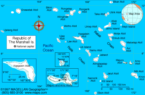
Map of
Marshall Islands
President: Christopher Loeak (2012)
Total area: 70 sq mi (181 sq km), includes
the atolls of Bikini, Eniwetok, and Kwajalein
Population (2014 est.): 70,983 (growth
rate: 1.72%); birth rate: 26.36/1000; infant mortality rate:
21.39/1000; life expectancy: 72.58
Capital and largest city (2011 est.):
Majuro, 31,000
Monetary unit: U.S. Dollar
Languages:
Marshallese (official) 98.2%, other languages 1.8% (1999 census)
note: English (official), widely spoken as a second language
Ethnicity/race:
Marshallese 92.1%, mixed Marshallese 5.9%, other 2% (2006)
Religions:
Protestant 54.8%, Assembly of God 25.8%, Roman Catholic
8.4%, Bukot nan Jesus 2.8%, Mormon 2.1%, other Christian 3.6%, other
1%, none 1.5% (1999 census)
National Holiday:
Constitution Day, May 1
Literacy rate: 93.7% (1999)
Economic summary: GDP/PPP (2012
est.): $475.4 million; per capita $8,700. Real growth rate: 2.3%. Inflation: 12.9%. Unemployment:
36%. Arable land: 11.11%. Agriculture:
coconuts, tomatoes, melons, taro, breadfruit, fruits; pigs,
chickens. Labor force: 10,480 (2011 est); agriculture 11%,
industry 16.3%, services 72.7% (2011). Industries: copra,
tuna processing, tourism, craft items from seashells, wood, and
pearls. Natural resources: coconut products, marine products,
deep seabed minerals. Exports: $50.14 million (2011):
copra cake, coconut oil, handicrafts, fish. Imports: $118.7
million (2011): foodstuffs, machinery and equipment, fuels,
beverages, and tobacco. Major trading partners: U.S., Japan,
Australia, China, New Zealand, Singapore, Fiji, Philippines
(2004).
Communications: Telephones: main lines
in use: 4,400 (2010); mobile cellular: 3,800 (2010). Broadcast media:
no TV broadcast station; a cable network is available on Majuro with
programming via videotape replay and satellite relays; 4 radio broadcast
stations; American Armed Forces Radio and Television Service (AFRTS)
provides satellite radio and television service to Kwajalein Atoll
(2009).
Internet Service Providers (ISPs): 3 (2012). Internet
users: 2,200 (2009).
Transportation: Railways: 0 km.
Roadways: total: 2,028 (includes 75 km of expressways). Ports and
harbors: Enitwetak Island, Kwajalein, Majuro. Airports: 15 (2013).
International disputes: claims U.S.
territory of Wake Island.
-------------------- o --------------------
No comments:
Post a Comment