MAURITANIA
Government: Military rule. The legal system is based on Islam.
History: Mauritania was first inhabited by blacks and Berbers, and it was a center for the Berber Almoravid movement in the 11th century, which sought to spread Islam through western Africa. It was first explored by the Portuguese in the 15th century, but by the 19th century the French had gained control. France organized the area into a territory in 1904, and in 1920 it became one of the colonies that constituted French West Africa. In 1946, it was named a French overseas territory.
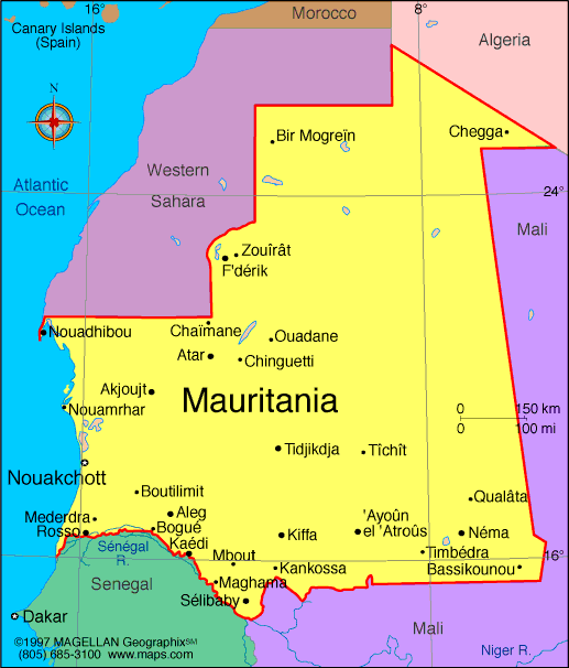
Map of
Mauritania
President: Muhammad Ould Abdel Aziz (2009)
Prime
Minister: Yahya Ould Hademine (2014)
Land area: 397,837 sq mi (1,030,400 sq
km); total area: 397, 953 sq mi (1,030,700 sq km)
Population (2014 est.): 3,516,806 (growth
rate: 2.26%); birth rate: 31.83/1000; infant mortality rate: 56.06/1000;
life expectancy: 62.28
Capital and largest city (2011 est.):
Nouakchott, 786,000
Monetary unit: Ouguiya
National name: Al Jumhuriyah al Islamiyah
al Muritaniyah
Languages:
Arabic (official and national), Pulaar, Soninke, Wolof (all national languages), French, Hassaniya (a variety of Arabic)
Ethnicity/race:
black Moors (Haratines - Arab-speaking slaves, former
slaves, and their descendants of African origin, enslaved by white
Moors) 40%, white Moors (of Arab-Berber descent, known as Bidhan) 30%,
black Africans (non-Arabic speaking, Halpulaar, Soninke, Wolof, and
Bamara ethnic groups) 30%
Religion:
Islam 100%
National Holiday:
Independence Day, Nov. 28
Literacy rate: 58.6% (2011 est.)
Economic summary: GDP/PPP (2013 est.):
$8.2046 billion; per capita $2,200. Real growth rate: 6.4%.
Inflation: 4.6%. Unemployment: 30% (2008 est.).
Arable land: 0.44%. Agriculture: dates, millet, sorghum,
rice, corn; cattle, sheep. Labor force: 1.318 million (2007);
agriculture 50%, services 48%, industry 2% (2001 est.).
Industries: fish processing, mining of iron ore and gypsum.
Natural resources: iron ore, gypsum, copper, phosphate,
diamonds, gold, oil, fish. Exports: $2.728 billion (2013
est.): iron ore, fish and fish products, gold. Imports: $3.335
billion (2013 est.): machinery and equipment, petroleum
products, capital goods, foodstuffs, consumer goods. Major trading
partners: Japan, France, Germany, Spain, Italy, Belgium,
Côte d'Ivoire, China, U.S., Brazil (2012).
Communications: Telephones: main lines in
use: 65,100 (2012); mobile cellular: 4.024 (2012). Broadcast
media: one state-run TV (Television de Mauritanie) and one state-run
radio network (Radio de Mauritanie); Television de Mauritanie has three
channels, Al Mahadra station (for Islamic content) and Channels 1 and 2,
which cover news, sports, and other programming; Radio de Mauritanie
runs 12 regional stations as well as a radio station for youth and the
Holy Quran station; five private TV channels and five private radio
stations also broadcast from Mauritania; six private international radio
stations broadcast in Mauritania on the FM band; with satellite
connections, Mauritanians also have access to hundreds of foreign TV
channels (2013). Internet Service Providers
(ISPs): 22 (2012). Internet users: 75,000 (2009).
Transportation: Railways: total: 728 km
(2008). Highways: total: 10,628 km; paved: 3,158 km; unpaved:
7,470 km (2010). Waterways: some navigation possible on the Senegal River.
Ports and terminals: Nouadhibou, Nouakchott.
Airports: 30 (2013).
International
disputes: Mauritanian claims to Western Sahara have been dormant
in recent years.
-------------------- o --------------------
No comments:
Post a Comment