MICRONESIA
Geography: The Federated States of Micronesia is composed of the island states of Yap, Chuuk (Truk), Pohnpei (Ponape), and Kosrae, all in the Caroline Islands. The islands vary geologically from high mountainous islands to low coral atolls, with volcanic outcroppings on Pohnpei, Kosrae, and Chuuk. They are located 3,200 mi (5,150 km) west-southwest of Hawaii, in the north Pacific Ocean.
Government: Constitutional government in free association with the United States since Nov. 1986.
History: The islands, inhabited by Micronesian and Polynesian peoples, were colonized by Spain in the 17th century. Germany purchased them from Spain in 1898. They were occupied by the Japanese in 1914, but American forces seized them from the Japanese during World War II. On April 2, 1947, the United Nations Security Council created the Trust Territory of the Pacific Islands. The trust placed the Northern Mariana, Caroline, and Marshall Islands under the administration of the United States.
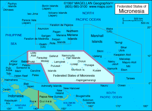
Map of
Micronesia
President: Peter M. Christian (2015)
Total area: 271 sq mi (702 sq km). Land area,
same (includes islands of Pohnpei, Yap, Chuuk, and Kosrae)
Population (2014 est.): 105,681 (growth
rate: –0.42); birth rate: 20.97/1000; infant mortality rate:
21.93/1000; life expectancy: 72.35
Capital (2011 est.):
Palikir 7,000
Monetary unit: U.S. Dollar
Languages:
English (official and common language), Chuukese, Kosrean, Pohnpeian, Yapese, Ulithian, Woleaian, Nukuoro, Kapingamarangi
Ethnicity/race:
Chuukese/Mortlockese 49.3%, Pohnpeian 29.8%, Kosraean
6.3%, Yapese 5.7%, Yap outer islanders 5.1%, Polynesian 1.6%, Asian
1.4%, other 0.8% (2010 est.)
Religions: Roman
Catholic 54.7%, Protestant 41.1% (includes Congregational 38.5%, Baptist
1.1%, Seventh Day Adventist 0.8%, Assembly of God .7%), Mormon 1.5%,
other 1.9%, none 0.7%, unspecified 0.1% (2010 est.)
National Holiday:
Constitution Day, May 10
Literacy rate: 89% (1980 est.)
Economic summary: GDP/PPP
(2013
est.): $754 million; note: data are in 2013 US dollars; GDP
supplemented by grant aid, averaging perhaps $100 million annually; per
capita $7,300 (2013
est.). Real growth rate: 0.6%. Inflation: 3.4%.
Unemployment: 22% (2000 est.). Arable land: 2.86%.
Agriculture: black pepper, tropical fruits and vegetables,
coconuts, cassava (tapioca), betel nuts, sweet potatoes; pigs,
chickens; fish. Labor force: 15,920 (2011); agriculture:
0.9%, industry: 20.6%, services: 78.5%; note: two-thirds are
government employees (2011 est.). Industries: tourism,
construction; fish processing, specialized aquaculture; craft items
from shell, wood, and pearls. Natural resources: forests,
marine products, deep-seabed minerals. Exports: $24.9 million
(2009 est.): fish, garments, bananas, black pepper.
Imports: $132.7 million (2004 est.): food,
manufactured goods, machinery and equipment, beverages. Major
trading partners: Japan, U.S., Hong Kong, Guam (2006).
Communications: Telephones: main lines
in use: 8,400 (2012); mobile cellular: 27,600 (2012). Broadcast media:
no TV broadcast stations; each state has a multi-channel cable service
with TV transmissions carrying roughly 95% imported programming and 5%
local programming; about a half dozen radio stations (2009). Internet Service
Providers (ISPs): 4,668 (2012). Internet users: 17,000
(2009).
Transportation: Railways: 0 km.
Highways: total: 240 km; paved: 42 km; unpaved: 198 km (2000
est.). Ports and harbors: Colonia (Tomil Harbor), Lele Harbor, Pohnepi Harbor. Airports: 6 (2013).
International disputes: none.
-------------------- o --------------------
No comments:
Post a Comment