MOZAMBIQUE
Geography: Mozambique stretches for 1,535 mi (2,470 km) along Africa's southeast coast. It is nearly twice the size of California. Tanzania is to the north; Malawi, Zambia, and Zimbabwe to the west; and South Africa and Swaziland to the south. The country is generally a low-lying plateau broken up by 25 sizable rivers that flow into the Indian Ocean. The largest is the Zambezi, which provides access to central Africa.
Government: Multiparty republic.
History: Bantu speakers migrated to Mozambique in the first millennium, and Arab and Swahili traders settled the region thereafter. It was explored by Vasco da Gama in 1498 and first colonized by Portugal in 1505. By 1510, the Portuguese had control of all of the former Arab sultanates on the east African coast. Portuguese colonial rule was repressive.
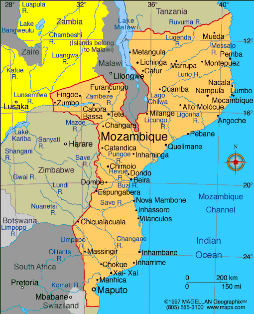
Map of
Mozambique
President: Filipe Nyusi (2015)
Prime Minister: Carlos Agostinho do Rosário
(2015)
Land area: 302,737 sq mi (784,089 sq km);
total area: 309,494 sq mi (801,590 sq km)
Population (2014 est.): 24,692,144 (growth
rate: 2.45%); birth rate: 38.83/1000; infant mortality rate: 72.42/1000;
life expectancy: 52.6. note: estimates for
this country explicitly take into account the effects of excess
mortality due to AIDS; this can result in lower life expectancy, higher
infant mortality, higher death rates, lower population growth rates, and
changes in the distribution of population by age and sex than would
otherwise be expected (July 2014 est.)
Capital and largest city (2011 est.):
Maputo, 1.15 million
Monetary unit: Metical
National
name: República de Moçambique
Languages:
Emakhuwa 25.3%, Portuguese (official) 10.7%, Xichangana
10.3%, Cisena 7.5%, Elomwe 7%, Echuwabo 5.1%, other Mozambican languages
30.1%, other 4% (1997 census)
Ethnicity/race:
African 99.66% (Makhuwa, Tsonga, Lomwe, Sena, and others), Europeans 0.06%, Euro-Africans 0.2%, Indians 0.08%
Religions:
Catholic 28.4%, Protestant 27.7% (Zionist Christian
15.5%, Evangelical Pentecostal 10.9%, Anglican 1.3%), Muslim 17.9%,
other 7.2%, none 18.7% (1997 census)
National Holiday:
Independence Day, June 25
Literacy rate: 56.1% (2010 est.)
Economic summary: GDP/PPP (2013 est.):
$28.15 billion; per capita $1,200. Real growth rate: 7%.
Inflation: 4.4%. Unemployment: 17% (1997 est.). Arable
land: 6.51%. Agriculture: cotton, cashew nuts, sugarcane, tea,
cassava (tapioca), corn, coconuts, sisal, citrus and tropical fruits,
potatoes, sunflowers; beef, poultry. Labor force: 10.55 million
(2013 est.); agriculture 81%, industry 6%, services 13% (1997 est.).
Industries: aluminum, petroleum products,
chemicals (fertilizer, soap, paints), textiles, cement, glass, asbestos,
tobacco, food, beverages. Natural resources: coal, titanium, natural
gas, hydropower, tantalum, graphite. Exports: $3.92 billion
(2013 est.): aluminum, prawns, cashews, cotton, sugar, citrus,
timber; bulk electricity. Imports: $7.068 billion (2013
est.): machinery and equipment, vehicles, fuel, chemicals, metal
products, foodstuffs, textiles. Major trading partners:
Belgium, South Africa, Italy, Spain, China, India, U.S., Australia, Portugal (2012).
Communications: Telephones: main lines in
use: 88,100 (2012); mobile cellular: 8.108 million (2012). Broadcast media:
1 state-run TV station supplemented by private TV station; Portuguese
state TV's African service, RTP Africa, and Brazilian-owned TV Miramar
are available; state-run radio provides nearly 100% territorial coverage
and broadcasts in multiple languages; a number of privately-owned and
community-operated stations; transmissions of multiple international
broadcasters are available (2007). Internet hosts: 89,737 (2012). Internet users: 613,600
(2009).
Transportation: Railways:
total: 4,787 km (2008). Highways: total: 30,331 km; paved:
6,303 km; unpaved: 24,028 km (2008 est.). Waterways: 460 km
(Zambezi River navigable to Tete and along Cahora Bassa Lake) (2010).
Ports and terminals: Beira, Maputo, Nacala. Airports: 98 (2013).
International disputes:
South Africa has placed military units to assist police operations
along the border of Lesotho, Zimbabwe, and Mozambique to control
smuggling, poaching, and illegal migration.
-------------------- o --------------------
No comments:
Post a Comment