MYANMAR
Geography: Slightly smaller than Texas, Myanmar occupies the Thailand/Cambodia portion of the Indochinese peninsula. India lies to the northwest and China to the northeast. Bangladesh, Laos, and Thailand are also neighbors. The Bay of Bengal touches the southwest coast. The fertile delta of the Irrawaddy River in the south contains a network of interconnecting canals and nine principal river mouths.
Government: Military regime.
History: The ethnic origins of modern Myanmar (known historically as Burma) are a mixture of Indo-Aryans, who began pushing into the area around 700 B.C. , and the Mongolian invaders under Kublai Khan who penetrated the region in the 13th century. Anawrahta (1044–1077) was the first great unifier of Myanmar.
In 1612, the British East India Company sent agents to Burma, but the Burmese doggedly resisted efforts of British, Dutch, and Portuguese traders to establish posts along the Bay of Bengal. Through the Anglo-Burmese War in 1824–1826 and two subsequent wars, the British East India Company expanded to the whole of Burma. By 1886, Burma was annexed to India, then became a separate colony in 1937.
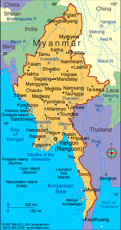
Map of Myanmar
President: Lt. Gen.
Thein Sein (2011)
Vice President: Vice President Sai Mouk Kham (2011)
Land area: 253,954 sq mi (657,741 sq km);
total area: 261,969 q mi (678,500 sq km)
Population (2014 est.): 55,746,253 (growth
rate: 1.03%); birth rate: 19.11/1000; infant mortality rate: 47.74/1000;
life expectancy: 65.24; density per sq km: 72
Capital and largest city (2011 est.):
Rangoon, 4.457 million
Other large
cities: Mandalay, 1.063 million; Nay Pyi Taw 1.06 million
Monetary
unit: Kyat
National
name: Pyidaungsu Myanmar Naingngandau
Languages:
Burmese, minority languages
Ethnicity/race:
Burman 68%, Shan 9%, Karen 7%, Rakhine 4%,
Chinese 3%, Mon 2%, Indian 2%, other 5%
Religions:
Buddhist 89%, Christian 4% (Baptist 3%, Roman
Catholic 1%), Islam 4%, Animist 1%, other 2%
Literacy rate: 92.7% (2011 est.)
Economic summary: GDP/PPP (2013 est.):
$111.1 billion; per capita $1,700. Real growth rate: 6.8%.
Inflation: 5.7%. Unemployment: 5.2%. Arable land:
15.94%. Agriculture: rice, pulses, beans, sesame, groundnuts,
sugarcane; hardwood; fish and fish products. Labor force: 34.31
million; agriculture 70%, industry 7%, services 23% (2001).
Industries: agricultural processing; knit and woven apparel;
wood and wood products; copper, tin, tungsten, iron; construction
materials; pharmaceuticals; fertilizer; cement; natural gas.
Natural resources: petroleum, timber, tin, antimony, zinc,
copper, tungsten, lead, coal, some marble, limestone, precious stones,
natural gas, hydropower. Exports: $9.043 billion (2013);
note: official export figures are grossly underestimated due to the
value of timber, gems, narcotics, rice, and other products smuggled to
Thailand, China, and Bangladesh: clothing, gas, wood products, pulses,
beans, fish, rice. Imports: $10.11 billion (2013 est.); note: import
figures are grossly underestimated due to the value of consumer goods,
diesel fuel, and other products smuggled in from Thailand, China,
Malaysia, and India: fabric, petroleum products, plastics,
machinery, transport equipment, construction materials, crude oil;
food products. Major trading partners: Thailand, India, China,
Japan, Singapore, South Korea, Malaysia (2012).
Communications: Telephones: main lines in
use: 556,000 (2012); mobile cellular: 5.44 million (2012). Broadcast media:
government controls all domestic broadcast media; 2 state-controlled TV
stations with 1 of the stations controlled by the armed forces; 2
pay-TV stations are joint state-private ventures; access to satellite TV
is limited; 1 state-controlled domestic radio station and 9 FM stations
that are joint state-private ventures; transmissions of several
international broadcasters are available in parts of Burma; the Voice of
America (VOA), Radio Free Asia (RFA), BBC Burmese service, the
Democratic Voice of Burma (DVB), and Radio Australia use shortwave to
broadcast in Burma; VOA, RFA, and DVB produce daily TV news programs
that are transmitted by satellite to audiences in Burma. Internet hosts: 1,055; note: as of Sept. 2000, Internet connections were legal
only for the government, tourist offices, and a few large businesses
(2012). Internet users: 110,000 (2009).
Transportation: Railways: total: 5,031 km
(2008). Highways: total: 34,377 km;
(2010 est.). Waterways: 12,800 km; 3,200 km navigable
by large commercial vessels. Ports and harbors: Moulmein, Sittwe, Rangoon.
Airports: 64 (2013).
International
disputes: over half of Burma's population consists of
diverse ethnic groups who have substantial numbers of kin in neighboring
countries; the Naf River on the border with Bangladesh serves as a
smuggling and illegal transit route; Bangladesh struggles to accommodate
29,000 Rohingya, Burmese Muslim minority from Arakan State, living as
refugees in Cox's Bazar; Burmese border authorities are constructing a
200 km (124 mi) wire fence designed to deter illegal cross-border
transit and tensions from the military build-up along border with
Bangladesh in 2010; Bangladesh referred its maritime boundary claims
with Burma and India to the International Tribunal on the Law of the
Sea; Burmese forces attempting to dig in to the largely autonomous Shan
State to rout local militias tied to the drug trade, prompts local
residents to periodically flee into neighboring Yunnan Province in
China; fencing along the India-Burma international border at Manipur's
Moreh town is in progress to check illegal drug trafficking and movement
of militants; over 90,000 mostly Karen refugees and asylum seekers
fleeing civil strife, political upheaval, and economic stagnation in
Burma were living in remote camps in Thailand near the border as of
year-end 2013.
-------------------- o --------------------
No comments:
Post a Comment