NAMIBIA
Geography: Namibia is bordered on the north by Angola and Zambia, on the east by Botswana, and on the east and south by South Africa. It is for the most part a portion of the high plateau of southern Africa, with a general elevation of from 3,000 to 4,000 ft.
Government: Republic.
History: The San peoples may have inhabited what is now Namibia more than 2,000 years ago. The Bantu-speaking Herero settled there in the 1600s. The Ovambo, the largest ethnic group today, migrated in the 1800s.
In the late 15th century, the Portuguese explorer Bartolomeu Dias became the first European to visit Namibia. Formerly called South-West Africa, the territory became a German colony in 1884. Between 1904 and 1908, German troops massacred tens of thousands of Herero, who had revolted against colonial rule. In 1915, during World War I, Namibian territory was taken over by South African forces. In 1921, it became a mandated territory of the League of Nations, under the administration of South Africa.
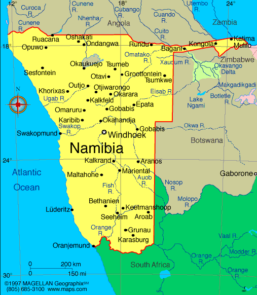
Map of Namibia
President: Hage Geingob
(2015)
Prime Minister: Saara Kuugongelwa-Amadhila (2015)
Total area: 318,694 sq mi (825,418 sq km)
Population (2013 est.): 2,182,852
(growth rate: 0.817%); birth rate: 21.11/1000; infant mortality rate:
45.61/1000; life expectancy: 52.17
Capital and largest city (2009 est.):
Windhoek, 342,000.
Monetary unit: Namibian dollar
Languages:
English 7% (official), Afrikaans is common
language of most of the population and of about 60% of the white
population, German 32%; indigenous languages: Oshivambo, Herero,
Nama: 1%
Ethnicity/race:
black 87.5%, white 6%, mixed 6.5%. Note: about
50% of the population belong to the Ovambo tribe and 9% to the
Kavangos tribe; other ethnic groups are Herero 7%, Damara 7%, Nama
5%, Caprivian 4%, Bushmen 3%, Baster 2%, Tswana 0.5%
Religions:
Christian 80%–90% (Lutheran at least
50%), indigenous beliefs 10%–20%
National Holiday:
Independence Day, March 21
Literacy rate: 88.8% (2010 est.)
Economic summary: GDP/PPP (2012
est.): $16.84 billion; per capita $7,800. Real growth rate:
4%. Inflation: 5.8%. Unemployment: 51.2%. Arable
land: .99%. Agriculture: millet, sorghum, peanuts, grapes;
livestock; fish. Labor force: 818,600; agriculture 16.3%,
industry 22.4%, services 61.3% (2008 est.). Industries:
meatpacking, fish processing, dairy products; mining (diamonds,
lead, zinc, tin, silver, tungsten, uranium, copper). Natural
resources: diamonds, copper, uranium, gold, lead, tin, lithium,
cadmium, zinc, salt, vanadium, natural gas, hydropower, fish; note:
suspected deposits of oil, coal, and iron ore. Exports: $4.657
billion (2012 est.): diamonds, copper, gold, zinc, lead,
uranium; cattle, processed fish, karakul skins. Imports:
$5.762 billion (2012 est.): foodstuffs; petroleum products and
fuel, machinery and equipment, chemicals. Major trading
partners: South Africa, U.S. (2006).
Communications: Telephones: main lines
in use: 140,000 (2011); mobile cellular: 2.24 million (2011). Broadcast media:
1 private and 1 state-run TV station; satellite and cable TV service is
available; state-run radio service broadcasts in multiple languages;
about a dozen private radio stations; transmissions of multiple
international broadcasters are available (2007). Internet Service
Providers (ISPs): 78,280 (2012). Internet users: 127,500,600
(2009).
Transportation: Railways: total: 2,626
km (2008). Highways: total: 64,189 km; paved: 5,477 km;
unpaved: 58,712 km (2010). Ports and harbors: Luderitz,
Walvis Bay. Airports: 112 (2012).
International disputes:
concerns from international experts and local populations over the
Okavango Delta ecology in Botswana and human displacement scuttled
Namibian plans to construct a hydroelectric dam on Popa Falls along the
Angola-Namibia border; managed dispute with South Africa over the
location of the boundary in the Orange River; Namibia has supported, and
in 2004 Zimbabwe dropped objections to, plans between Botswana and
Zambia to build a bridge over the Zambezi River, thereby de facto
recognizing a short, but not clearly delimited, Botswana-Zambia boundary
in the river.
-------------------- o --------------------
No comments:
Post a Comment