NAURU
Geography: Nauru (pronounced NAH-oo-roo) is an island in the Pacific just south of the equator, about 2,500 mi (4,023 km) southwest of Honolulu. Phosphate mining has virtually destroyed the tiny nation's ecology, turning its tropical vegetation into a barren, rocky wasteland.
Government: Republic.
History: In 1798, a British navigator became the first European to visit the island. Germany annexed it in 1888, and by the turn of the century, phosphate, a lucrative fertilizer, began to be mined. The island was placed under joint Australian, New Zealand, and British mandate after World War I. The Japanese occupied the island during World War II and forced 1,200 Nauruans—roughly two-thirds of the population—to relocate. In 1947, it became a UN trusteeship administered by Australia. By 1967, the phosphate mining industry was finally under the control of the islanders, and on Jan. 31, 1968, Nauru became one of the world's smallest independent republics. For a period of time, Nauru's phosphate made the tiny country's per capita income the highest in the world, after Saudi Arabia.
As its phosphate stores began to run out (by 2006, its reserves will be exhausted), the island was reduced to an environmental wasteland. Nauru appealed to the International Court of Justice to compensate for the damage from almost a century of phosphate strip-mining by foreign companies. In 1993, Australia offered Nauru an out-of-court settlement of 2.5 million Australian dollars annually for 20 years. New Zealand and the UK additionally agreed to pay a one-time settlement of $12 million each. Declining phosphate prices, the high cost of maintaining an international airline, and the government's financial mismanagement combined to make the economy collapse in the late 1990s. By the millennium Nauru was virtually bankrupt.
In 2000, the G7 nations put pressure on the country to review its banking system, which is used by Russian criminals for money laundering.
Since Sept. 2001, Nauru has accepted three boatloads of Asian refugees destined for Australia. Australia compensated the island with $20 million and other financial incentives for taking this refugee problem off its hands. The detention camps, which held more than 400 asylum seekers in 2003, are said to be extremely bleak and lack medical care.
Bernard Dowiyogo, elected in 2003 as president for the seventh time (nonsequentially), died in March 2003, and Ludwig Scotty, a senior cabinet minister, was elected in May 2003. In August, Scotty was sacked in a no-confidence vote, and René Harris was elected. But, typical of Nauru's tumultuous politics, by June 2004 Scotty had again regained the presidency. Scotty lost another no-confidence vote in Parliament in Dec. 2007 and was replaced by Marcus Stephens, a former member of Parliament and minister of finance and education.
In Nov. 2010, after nine months of deadlock caused by a parliament lacking a majority party, former president Ludwig Scotty accepted the nomination as speaker. This gave the government a majority 10 seats to 8, which was used to reelect Marcus Stephen as president (defeating Milton Dube).
Amid allegations of corruption, President Marcus Stephen resigned in Nov. 2011. Frederick Pitcher was elected president, but was soon ousted in a no-confidence vote. Parliament announced the successful election of Sprent Dabwido as Nauru's new president on Nov. 15, 2011. In September 2012, Dabwido addressed the United Nations General Assembly for the first time. He spoke on behalf of Nauru and urged the UN to seriously address the issue of climate change.
On June 11, 2013, Baron Waqa was elected president by parliament after Dabwido chose not to run for reelection. Waqa defeated opposition nominee and former Finance Minister Roland Kun by a vote of 13 to 5. Waqa has been a member of the Parliament of Nauru since 2003. He has also served as Nauru's Minister of the Interior and Minister of Education.
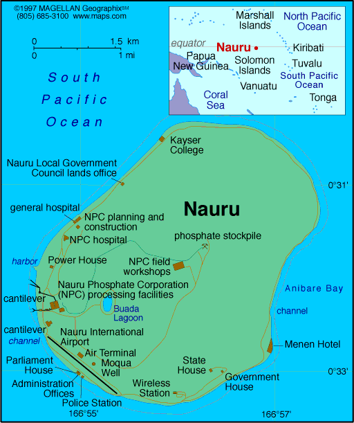
Map of Nauru
President: Baron Waqa (2013)
Total area: 8 sq mi (21 sq km)
Population (2014 est.): 9,488 (growth
rate: 0.56%); birth rate: 25.61/1000; infant mortality rate: 8.21/1000;
life expectancy: 66.4
Capital:
no official capital; government offices in Yaren District
Monetary unit: Australian dollar
Languages:
Nauruan 93% (official, a distinct Pacific Island
language), English 2% (widely understood, spoken, and used for most
government and commercial purposes), other 5% (includes I-Kiribati 2%
and Chinese 2%)
note: percentages represent main language spoken at home; Nauruan
is spoken by 95% of the population, English by 66%, and other languages
by 12% (2011 est.)
Ethnicity/race:
Nauruan 58%, other Pacific Islander 26%,
Chinese 8%, European 8%
Religions:
Protestant 60.4% (includes Nauru
Congregational 35.7%, Assembly of God 13%, Nauru Independent Church
9.5%, Baptist 1.5%, and Seventh Day Adventist .7%), Roman Catholic 33%,
other 3.7%, none 1.8%, unspecified 1.1% (2011 est.)
National Holiday:
Independence Day, January 31
Literacy rate: n.a
Economic summary: GDP/PPP (2005
est.): $60 million; per capita $5,000. Real growth rate: n.a.
Inflation: n.a. (2011). Unemployment: 90% (2004
est.). Arable land: 0%. Agriculture: coconuts.
Labor force: mining phosphates, public administration,
education, and transportation. Industries: phosphate mining,
offshore banking, coconut products. Natural resources:
phosphates. Exports: $64,000 (2005): phosphates.
Imports: n.a. (2004 est.): food, fuel,
manufactures, building materials, machinery. Major trading
partners: none.
Special relationship within the Commonwealth of Nations
Communications: Telephones: main lines
in use: 1,900 (2009); mobile cellular: 6,800 (2012). Broadcast media: 1
government-owned television station broadcasting programs from New
Zealand sent via satellite or on videotape; 1 government-owned radio
station, broadcasting on AM and FM, utilizes Australian and British
programs (2009). Internet hosts: 8,162 (2012). Internet users: n.a.
Transportation: Railways: total: 5 km;
note: used to haul phosphates from the center of the island to
processing facilities on the southwest coast (2001). Roadways: total: 30 km; paved: 24 km (2002). Ports
and harbors: Nauru. Airports: 1 (2013).
International disputes: none.
-------------------- o --------------------
No comments:
Post a Comment